|
(last updated 10/3/2023)
If you are familiar with the mileage signs posted at the terminus points of US 6 and US 20, you might point to those and say, "The answer is plain to see: US 20 is 160 miles longer than US 6."
If both of those signs were accurate, then obviously US 20 would be longer. But the fact is, only the US 6 sign is accurate, whereas the US 20 sign significantly overstates the true mileage. In reality, the mileages of the two routes are very close, and in fact there is every reason to believe US 6 is actually a slightly longer route.
I first realized that based on measurements I took in 2016, and later refined in 2020. But before moving on, let's step back and ask: what exactly is the US 20 sign saying? As I see it, it could be interpreted in two different ways:
At this point you may well be wondering, "How can the author be so certain that '3365' is the figure that is wrong, as opposed to whatever number he came up with?" The answer is because in 2021 the source of the misinformation was identified, when I and others obtained a copy of AASHTO's 1989 route log (that is the most recent version they have published). We learned that the figure of "3365 miles" listed therein was never intended to represent the cross-country mileage of US 20. Let me explain.
When one takes a careful look at the route log, the only way to arrive at a figure of 3365 miles is by including the mileage of all bannered routes associated with US 20 (i.e. all US 20 business loops, bypass routes, alternate routes, etc). And in fact, this was expressly noted in the route log itself at the top of the very first page:
Note the last statement there. Of course when traveling US 20 across the country, one would not drive (for example) both mainline US 20 (which goes around Rockford IL) and Business 20 (which goes through Rockford). Rather, a traveler would choose one or the other. So as it turns out, that figure of 3365 miles never represented US 20's actual cross-country mileage. In order to get a more accurate figure, we have to subtract out all of the redundant mileage from the AASHTO log. When we count only the mileage for mainline US 20, the 1989 total would have come to only 3237 miles.
(Incidentally, that same issue resulted in overstated cross-country mileage for US 6 as well. The 1989 log listed a figure of 3249 miles for US 6, but analysis reveals that figure included 42 miles of bannered routes, so the actual total at the time for mainline US 6 would have been 3207 miles.) Unfortunately, since 1989 the misleading figures of 3365 miles and 3249 miles have been used in many publications to represent cross-country mileages for US 20 and US 6, despite the fact that they were never intended for that purpose. Even otherwise-respectable articles like this one (published by the FHWA) cite AASHTO's 1989 route log as the source of their mileage information. So it is easy to see why many people assume those numbers are valid. But even so, if we are comparing 3207 miles vs. 3237 miles, that means US 20 is still 30 miles longer than US 6, correct? Well, hold on, there's more: it is also important to take into consideration the fact that the AASHTO log is over 30 years old. During those intervening three decades, a number of bypasses and realignments have been opened to traffic on both routes. Obviously each of these changes impact the total mileage, some of them significantly. So what we really need is a current source of cross-country mileage figures. But unfortunately there is no such source. There is no federal government agency that has a need to maintain accurate mileage logs of our inter-state highway networks. The closest such entity would be AASHTO (although that is not a federal organization). My understanding is that AASHTO has made attempts to update their route log since 1989, but not all of the state departments of transportation were willing or able to provide all the necessary mileage data. Well then, can we get mileages directly from the departments of transportation in each state? If so, then we could simply add their figures to come up with cross-country totals for US 6 and US 20. As it turns out, most state DOTs do have accurate mileage figures, and most have made that data available to the public. But there are exceptions, and unfortunately some of those exceptions are in states through which US 6 and/or US 20 pass. As a result, I turned to a method of measuring mileage that is uniform across all 48 states: online mapping services. In 2016 I used Mapquest, and in 2020 I measured again using Google Maps (the results were almost exactly the same, but using Google was easier and quicker). Some have expressed valid concerns about this method, and I deal with some of those concerns below. But it is noteworthy that in most cases the Google results were very close to the figures provided by the state DOTs, suggesting that the Google method is indeed quite accurate. In the lists that follow, I have shown both the Google figures and the DOT figures for the sake of comparison:
More recent measurements show that US 6 is now longer than US 20
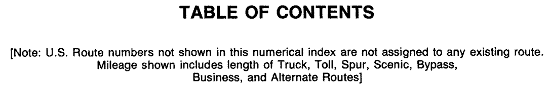
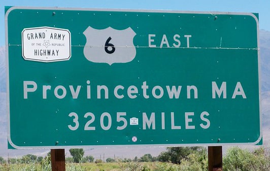
Using Google calculations, if one were to travel between Bishop California and Provincetown Massachusetts, strictly following the route of US 6, by the time they completed their journey they would have driven 3205.4 miles. Or, if we go with DOT figures, then the cross-country distance along US 6 is 3216.4 miles. Either way, the US 6 sign shown above (posted near Bishop) is admirably accurate.
If a driver traveled between Newport Oregon and Boston Massachusetts, unwaveringly following the signs for US 20, they would end up going a total of 3204.5 miles (according to Google measurements). Or, according to DOT figures the mileage would be 3204.8 miles. Regardless, the US 20 sign shown above overstates the mileage by at least 160 miles (there are actually two of those signs: one in Boston and the other in Newport). So if we compare Google measurements, US 6 is one mile longer than US 20 (actually nine tenths of a mile). Or if we go with DOT figures, then US 6 is over 11 miles longer than US 20.
Missing DOT mileages
Above I reported the mileages of each route based on the state DOT totals. But those figures require some explanation, because at the time of the latest update to this page, I still did not have DOT mileages from three states (Pennsylvania, Illinois, and Colorado). Instead, for those states I substituted the mileages listed in AASHTO's 1989 route log (subtracting any bannered routes, of course!) But obviously the goal is to obtain current, official DOT figures from all of the states. So if you are aware of a DOT source for mileages in PA, IL, and/or CO, please contact me, and I will update those statistics.
What specific DOT sources were used?
You are welcome to examine the Google Sheet that I use to maintain up-to-date totals of both sets of mileages (i.e. the mileage according to Google Maps, and the mileage according to the various state DOTs). I also use that to keep track of specifically where I obtained the DOT info, so included there are links to DOT online sources (if applicable), as well as several tabs that contain screenshots of DOT-provided information. If you have questions about anything on there, please contact me.
Why is there PennDOT mileage for US 20, but not US 6?
Actually, there is a PennDOT source that reports statewide mileage for both US 6 and US 20. However, the mileage for US 6 was over-reported by about 40 miles, so I did not cite that figure. I have contacted PennDOT about this more than once. On one occasion a PennDOT employee divulged that their figure was overstated because it included the mileage of not only mainline US 6, but also US 6N, plus three US 6 business routes (in other words, the same problem as AASHTO's route log). But my followup attempt to get a breakdown of the mileage for each of those individual routes was not successful.
Why don't you have the mileages through Illinois?
IDOT publishes lots of their data online, but unfortunately their data that lists mileage by route number is limited to interstate highways only. I have attempted to contact IDOT multiple times, but have never received a response.
What about Colorado?
CDOT makes their Online Transportation Information System (OTIS) available to the public. This system shows that the US 6 milepost at the Nebraska line is 464.287. However, that figure cannot be used for US 6's statewide mileage, because there are a couple places where CDOT's mileposts do not correspond to actual road mileage (as is common in any state where a highway has been realigned after the mileposts were placed). These offsets result in the mileposts understating the total length of US 6 by about seven miles. I have contacted CDOT to obtain more accurate statewide mileage, but have not had a response.
What about the mileage of US 20 through Yellowstone National Park?
Aware that US 20 does not exist in Yellowstone National Park, some people have concluded that the figure in AASHTO's 1989 log must have included US 20's implied mileage through Yellowstone, and that is what explains the inflated mileage total. But actually, that would be an incorrect assumption, because the route log actually did not include any mileage through Yellowstone.
In fact, none of the other figures above include any mileage in Yellowstone either, because US 20 actually does not exist within the boundaries of Yellowstone. One might argue, "But to drive across the country on US 20, you have to drive through Yellowstone!" I will acknowledge that, but again, while you are in Yellowstone, you are technically not on US 20 (in fact, that is why, since 1941, AASHTO has shown US 20 as two separate segments). So when we compare mileages that are actually defined as US routes, US 6 is slightly longer than US 20. Now, here is where I address the possibility (noted towards the beginning of this page) that the US 20 sign is really just saying "the total distance between Boston and Newport is 3365 miles, even though that entire distance in not on US 20". If people want to know the overall cross-country mileage along US 20 (even though the Yellowstone segment is technically not US 20), then I guess it is reasonable to include Yellowstone mileage. But even if we do, "3365 miles" still overstates the distance by at least 68 miles, and as much as 82 miles. The reason for that uncertainty is because there are two logical routes for US 20 travelers to take through Yellowstone: the South Loop route or the Norris Canyon route. The former is 13.7 miles longer than the latter, but since neither one is designated as US 20, it is not possible to determine which route is the one that should be used by US 20 travelers. And regardless, even if one is of the opinion that the Boston-Newport signs should include the non-US 20 mileage through Yellowstone, the figure of 3365 miles is still overstated. A more accurate measurement would be either 3283 or 3297 miles (depending which route one chooses through the Park).
Can mileages that are calculated with Google Maps be trusted?
While this is definitely a valid concern, it is quickly becoming a moot point. At the time of the latest update to this article, we have accurate mileages from official DOT sources in all but three states. When that remaining information has been obtained, it will not matter what Google says.
But in the meantime, I do use Google to reality-check the DOT figures. Can those Google measurements be trusted? First, let's talk about precision. Google will return results that are precise to the tenth-mile, but only on segments that are less than 100 miles in length. So I had to measure a bunch of short segments and add them together to come up with a total for each state. At first glance it would seem that precision to the tenth-mile should be adequate. But consider: if each segment has an error margin of a tenth-mile, then we have to multiply that by the amount of separate road segments in each state to get an overall error margin. Some of the states are over 400 miles wide, so Google results in states like that could theoretically be off by up to a half-mile. And then consider that we're talking about overall distances of about 3200 miles. That means using Google it is necessary to measure at least 33 different segments in order to come up with a cross-county total. Multiply that by a tenth-mile error margin, and we could potentially be off by 3.3 miles. On the one hand, that's not bad at all. But on the other hand, that error margin appears to be a significant percentage of the total difference in mileage between US 6 and US 20! So in that sense, precision to the tenth-mile is really not good enough to determine which route is longer. But again, we have measurements from nearly all the states now, and most DOTs are precise to the nearest hundredth-mile, or even thousandth-mile. Of course all of that assumes Google Maps has a high rate of accuracy. Is that a reasonable assumption? Again, since most of my results using Google were very close to official DOT mileages, I am confident that Google results are quite reliable.
Conclusion
Many sources claim that US 20 is by far the longest US route, but the truth is more nuanced than that. My intention with this page is to demonstrate, first, that US 20 is not nearly as long as most sources claim it is. And, secondly, the data I have found so far convinces me that US 6 is actually just a bit longer than US 20 now.
Was US 20 ever longer than US 6?
Well, it depends how (and what) one measures. As I interpret the situation, no, US 20 was never the longest US route. But let's start from the beginning...
When the US routes were inaugurated in late 1926, US 30 was the longest: 3472 miles, according to AASHO's 1927 route log (although that was probably overstated, because the route log from just two years later listed it at only 2998 miles). By the time of the 1935 route log, US 30 was listed at only 2838 miles. Meanwhile US 50 had been extended west from Sacramento to San Francisco, and it was listed as the longest at 2917 miles. All during this timeframe, US 20 was not a coast-to-coast route, as its west terminus was at the East Entrance of Yellowstone National Park. According to the route logs from 1927-1935, its length ranged from 2424 miles to 2542 miles. In 1937 US 6 was extended all the way west to the Pacific coastal city of Long Beach. Measuring 3576 miles back then (according to the 1942 route log), US 6 obtained (and still holds) the record for the longest-ever highway in the U.S. Around 1941 AASHO commissioned a separate western segment of US 20, running between West Yellowstone and the Oregon coast. Since then, those two segments have always been listed separately in AASHO's/AASHTO's point-to-point route logs (referred to as "US 20 eastern segment" and "US 20 western segment"). In my opinion it is misleading to combine the two mileages into one figure for US 20, because that implies it is a single continuous route with no gaps (discussed in more detail on this page). However, that is exactly what AASHO did in their 1942 route log (and ever since then as well): despite showing US 20[e] and US 20[w] as separate routes, they nevertheless combined the lengths of the two segments, listing "US 20" as 3277 miles. So if one were to accept that figure, then "US 20" leapfrogged both US 30 and US 50 in total length, but did not yet surpass US 6. In 1964, CalTrans truncated US 6 to Bishop, meaning it was reduced in length by about 300 miles. So at that point in time, US 6's total mileage slid just below the combined total of US 20's two segments, and if one were to accept the combined mileage of "US 20", then that route would have held the distance title for roughly the next half-century. At this point I have no reason to doubt the mileages listed in AASHTO's 1989 route log (once we subtract the mileage of bannered routes); according to that the combined "US 20" was about 30 miles longer than US 6. But after 1989, it seems no one continued to keep the measurements updated. We in the road enthusiast community kept repeating, "US 20 is the longest route", even though that fact became more outdated with each passing year, and even though no one was verifying it. But meanwhile, in states all across the country, transportation departments continued to make changes to both US 6 and US 20, with each new alignment increasing or decreasing the total mileage. At some point, the length of "combined US 20" quietly dropped back below that of US 6... but no one was paying any attention at the time.
When did US 6 become longer than US 20?
Again, as I interpret it, US 6 became longer than US 20 in 1937, and it has been the longest route ever since then. But for those who accept the combined mileage of "US 20", I cannot answer the question with certainty, partly because it depends whether we accept the Google mileages or the DOT mileages. If we assume that Google is closer to reality (meaning there is truly only about one mile of difference between the two routes), then US 6 surpassed "US 20" in 2019. That was the year that Iowa DOT rerouted US 6 around Council Bluffs, increasing its length by about three miles.
On the other hand, the DOT mileages suggest that US 6 is about 11 miles longer than the combined mileage of US 20. If so, then US 6 surpassed "US 20" earlier than 2019, but I am not sure exactly when. In 2016 Oregon completed the Eddyville bypass, which reduced the length of US 20[w] by about three miles. That, in combination with the Council Bluffs change noted above, gives us about six miles. But we need an additional five miles in order to get to a total difference of 11. To gain that much mileage, we may have to go all the way back to when the US 20[e] freeway was completed across Iowa (which reduced its mileage by about 19 miles).
I will continue to update this page as more data becomes available.
More about the mileage (and midpoint) US 6 More about the mileage (and midpoint) of US 20
Additional research: Mike Roberson
8 Comments
Chris
8/23/2020 06:40:33 pm
I just saw this blog entry today. Like all of your entries, it was a very enjoyable read! 8/23/2020 08:07:56 pm
To me it's astonishing that people keep citing that 1989 figure for the 3365-mile length of US 20, without considering a.) whether it was even correct back then, or b.) whether anything along that highway has changed over the past 30+ years. Consequently I'm always looking for examples of things that have changed, so thanks for bringing my attention to the Eddyville reroute.
Traildriver
8/12/2023 06:16:10 am
Another road with a 'gap'...US 34 through Rocky Mountain National Park? It has a short segment on the west side of the Park where it terminates at the junction with US 40. I don't think Trail Ridge Road is considered part of US 34, nor is it signed as such, but it does connect the parts.... 8/12/2023 08:19:13 am
It's true that US 34 has what I call a "seasonal" gap, but that's a little different than US 20, which has an "official" gap. US 34 actually does exist within Rocky Mtn. Nat'l Park, and NPS signposts it in a few places. I discuss all these nuances on this page: https://www.usends.com/gaps.html
Richard Sawyer
5/18/2024 06:48:55 pm
The US 20 situation is unique. I-84 and the others are obviously no more intended to be the same road than, say, every I-280. However, the gap in US 20 exists simply because the powers that were decided that Yellowstone's roads were park roads and not U.S. numbered highways. A continuous US 20, while not official, is clearly implied, and I really can't blame anybody for including it in US 20 mileage. Mind you, I have no strong opinion on the matter myself. 8/24/2020 10:30:03 am
I have the solution... Let's encourage MassDOT to extend US 20 to end on the OTHER cape of Massachusetts Bay. A 38.9 mile extension eastward to Rockport, MA would just about do it, right? 5/24/2024 05:27:09 am
I learned from personal experience in October 2021 that mileage from Google Maps is accepted in California courts and by auto and health insurance companies. My attorney used Google Maps to prove that my accident on a lonely desert road was not where the police report map showed it. Your comment will be posted after it is approved.
Leave a Reply. |
AuthorCategories
All
Archives
July 2024
|

 RSS Feed
Copyright © 1998-2024
