US Ends .com
  • Home
  • Store
    • US highway book
    • US highway map
    • Florida US highway map
  • Endpoints
    • US 1 - US 9 >
      • 1 >
        • 201
        • 301
        • 401 [i]
        • 401 [ii]
        • 401
        • 501
        • 601
        • 701
      • 2w >
        • 102
      • 2e >
        • 202
        • 302
      • 3
      • 4 >
        • 104
      • 5
      • 6 >
        • 106
        • 206
      • 7
      • 8
      • 9 >
        • 109*
        • 209
        • 309
    • US 10 - US 19 >
      • 10 >
        • 110
        • 210
        • 310
        • 410
      • 11 >
        • 111
        • 211
        • 311
        • 411 [i]
        • 411 [ii]
        • 411
        • 511*
        • 611
        • 711*
      • 12 >
        • 112
        • 212
        • 312
      • 13 >
        • 113
        • 213
      • 14
      • 15
      • 16 >
        • 116
        • 216
      • 17 >
        • 17-1
        • 117 [i]
        • 117
        • 217
      • 18 >
        • 118
        • 218
      • 19 >
        • 119
        • 219
        • 319
    • US 20 - US 29 >
      • 20e >
        • 120
        • 220
        • 320
        • 420
      • 20w
      • 21 >
        • 121 [i]
        • 121
        • 221
        • 321
        • 421
        • 521
      • 22 >
        • 122 [i]
        • 122 [ii]
        • 222
        • 322
        • 422e
        • 422w
        • 522
        • 622*
      • 23 >
        • 123 [i]
        • 123
        • 223
      • 24 >
        • 124
        • 224
      • 25
      • 26 >
        • 126
      • 27 >
        • 127
        • 227
      • 28
      • 29 >
        • 129
    • US 30 - US 39 >
      • 30 >
        • 130
        • 230
        • 330
        • 430
        • 530
        • 630*
        • 730
        • 830
      • 31 >
        • 131
        • 231
        • 331 [i]
        • 331
        • 431
      • 32
      • 33
      • 34
      • 35
      • 36 >
        • 136
      • 38 >
        • 138
    • US 40 - US 49 >
      • 40 >
        • 140
        • 240
        • 340
      • 41 >
        • 141
        • 241 [i]
        • 241 [ii]
        • 341
        • 441 >
          • 441n
          • 441s
        • 541
        • 641
      • 42
      • 43
      • 44
      • 45
      • 46
      • 48 [i]
      • 48 [ii]
      • 48
      • 49
    • US 50 - US 59 >
      • 50 >
        • 150
        • 250
        • 350
        • 450
        • 550
        • 650
      • 51 - 55 >
        • 51 >
          • 151
        • 52 >
          • 152
        • 53
        • 54 >
          • 154
        • 55
      • 56 >
        • 156
      • 57
      • 58 >
        • 158
        • 258
      • 59 >
        • 159
        • 259
    • US 60 - US 69 >
      • 60 >
        • 160
        • 260
        • 360
        • 460
      • 61 - 65 >
        • 61 >
          • 161
        • 62
        • 63 >
          • 163 [i]
        • 64 >
          • 164 [i]
          • 164 [ii]
          • 264
        • 65 >
          • 165
      • 66 >
        • 166
        • 266
        • 366 [i]
        • 366 [ii]
        • 466 [i]*
        • 466 [ii]
        • 566
        • 666
      • 67 >
        • 167
      • 68 >
        • 168
      • 69 >
        • 169
    • US 70 - US 79 >
      • 70 >
        • 170
        • 270 [i]*
        • 270
        • 370
        • 470
      • 71 >
        • 171
        • 271
        • 371 [i]
        • 371 [ii]
        • 371
      • 72 - 76 >
        • 72
        • 73
        • 74
        • 75 >
          • 175
          • 275
        • 76 >
          • 176
          • 276
      • 77 >
        • 177
        • 277
        • 377
      • 78 >
        • 178
        • 278
        • 378
      • 79
    • US 80 - US 89 >
      • 80 - 84 >
        • 80 >
          • 180 [i]
          • 180
          • 280
          • 380
        • 81 >
          • 181
          • 281
        • 82
        • 83 >
          • 183
          • 283
          • 383
        • 84
      • 85 - 89 >
        • 85 >
          • 185
          • 285 [i]
          • 285
          • 385 [i]
          • 385
          • 485
        • 87 >
          • 187
          • 287n
          • 287s
        • 89n
        • 89s >
          • 189 [i]
          • 189
    • US 90 - US 99 >
      • 90 - 94 >
        • 90 >
          • 190
          • 290
        • 91 >
          • 191 >
            • 191n
            • 191s
          • 491
        • 92 >
          • 192
        • 93
        • 94
      • 95 -98 >
        • 95 >
          • 195
          • 295
          • 395
        • 96 [i]
        • 96
        • 97 >
          • 197
        • 98
      • 99 >
        • 199
        • 299
        • 399
    • Anomalies >
      • 101
      • 163
      • 400
      • 412
      • 425
  • Places
    • A-L >
      • A >
        • Aberdeen
        • Albuquerque
        • Amarillo
        • Apalachicola
        • Astoria
        • Atlantic
      • B >
        • Baltimore
        • Baton Rouge
        • Bay Area
        • Bishop
        • Boone
        • Brady
        • Bristol
        • Brownsville
        • Brunswick
      • C >
        • Charleston
        • Chattanooga
        • Chicago
        • Cincinnati
        • Cleveland
        • Cody
        • Corpus
        • Cortez
        • Council Bluffs
        • Covington
        • Crescent
        • Cumberland Gap
      • D-E >
        • Dallas
        • Des Moines
        • Detroit
        • Dothan
        • Douglas
        • El Paso
        • Erie
        • Eugene
      • F >
        • Farmington
        • Flagstaff
        • Florence
        • Fox Valley
        • Franklin
      • G >
        • Gallup
        • Georgetown
        • Grand Junction
        • Grand Portage
        • Grayling
        • Great Falls
        • Greeley
      • H-I >
        • Hardeeville
        • Harrisburg
        • Holbrook
        • Idaho Falls
        • Int'l Falls
      • J-K >
        • Jacksonville
        • Joplin
        • Junction
        • Kansas City
        • Keokuk
        • Key West
        • Kingman
      • L >
        • Laredo
        • Lewiston
        • Long Beach
        • Los Angeles
        • Louisville
        • Lubbock
    • M-R >
      • M >
        • Mackinaw
        • Madison
        • Maryhill
        • Maysville
        • Miami
        • Midway
        • Miles City
        • Milford
        • Milwaukee
        • Minneapolis
        • Mobile 31
        • Mobile 31-43-45
        • Montgomery
        • Monticello
        • Mount Vernon
      • N-O >
        • Nags Head
        • Naples
        • Natchez
        • New Castle
        • New Orleans
        • Niagara
        • Norlina
        • Ocean City
        • Oklahoma City
      • P >
        • Pee Dee
        • Pembina
        • Pensacola
        • Petersburg
        • Philadelphia
        • Piegan
        • Pineville
        • Port Arthur
        • Portsmouth
      • Q-R >
        • Quad Cities
        • Rapid City
        • Raton
        • Reading
        • Richmond
        • Rockingham
        • Rouses Point
    • S-Z >
      • S >
        • San Antonio
        • San Antonio NM
        • San Diego
        • Santa Fe
        • Savannah
        • Sioux
        • Springer
        • Springfield
        • St. Ignace
        • St. John
        • St. Paul
        • St. Pete
      • T-U-V >
        • Tallahassee
        • Tampa
        • Toledo
        • Trinidad
        • Tuba City
        • Ucolo
        • VA Beach
      • W >
        • Walterboro
        • Waverly
        • West Memphis
        • Wilmington
        • Wilson
        • Wrightsville
      • Y >
        • Yellowstone E
        • Yellowstone N
        • Yellowstone NE
        • Yellowstone S
        • Yellowstone W
  • Highways
    • Map of all endpoints
    • Sources
    • History
    • 1926 almost-routes
    • Intra-state routes
    • Numbering
    • Colors
    • Gaps
    • Blog
  • Bonus
    • Colorado >
      • Lowest point
      • Antipodes
      • Toponymy >
        • Roots
      • Colloquialisms
      • Populations
      • Denvers
    • Washington Meridian
    • Watersheds >
      • Headwaters Hill
      • Three Waters Mtn.
      • Parting of the Waters
    • Geo-centers >
      • 48 states
      • 50 states
      • North America
    • State corners >
      • AZ-CO-NM-UT
      • CO-UT-WY
      • CO-NE-WY
      • CO northeast
      • CO-KS-NE
      • CO-KS-OK
      • CO-NM-OK
      • NM-OK-TX
      • NM southeast
      • TX northwest
  • Connect
    • Author/history
    • Rationale
    • Contact
    • Contributors
    • Submissions

US Highways Blog

The longest three-digit US routes

7/5/2020

1 Comment

 
(Last updated 2/28/2023)
​Of the "main" US highways (i.e. the one- and two-digit routes), the longest nine were all east-west routes (6, 20, 50, 30, 40, 60, 70, 80, 12).  And if we take the longest 16 highways, only one of them is a north-south route (US 1, shown in red here):
Picture
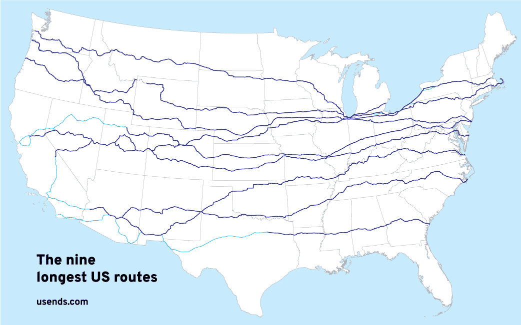
That stands to reason, because the United States is roughly twice as wide from east to west as it is from north to south.  So it makes sense that there would be more long east-west routes.  But does the same hold true if we look at the "branch" routes of the system (i.e. the three-digit routes)?
Not really.  The three longest branch routes are all north-south highways (287, 281, and 191).  The fourth-longest (160) does run east-west, but it is about 400 miles shorter than the longest north-south branch routes.  The next three longest also run north-south (395, 183, 385):
Picture

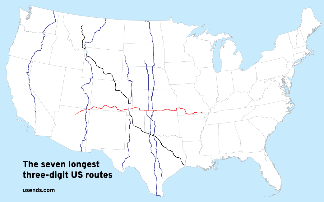
Technically, there is some debate about how to measure routes like US 287 and US 191, which consist of two disconnected segments (due to gaps through Yellowstone National Park).  If we consider the separate segments to be distinct routes, then US 281 is the longest 3dus, followed by US 287[s], US 160, US 395, US 183, US 191[s], and US 385.  Either way, the seven longest 3dus routes do not change; only their order changes.

​So, if the longest main routes run east-west, then why do the longest branch routes run north-south?
The following assumes you are familiar with the methodology that was originally used to assign US route numbers (if not, then you might benefit from this quick primer).  With that in mind, there were 50 (give or take) numbers available for main east-west US routes (evens from 2-98), and 50 for north-south routes (odds from 1-99).  But as mentioned previously, the 50 odd numbers had to be spread out over a distance roughly twice as wide as the distance that the 50 even numbers had to cover.

The 50 even numbers were more than enough to cover the main east-west routes.  In fact, nine of the even numbers were not immediately assigned in 1926 (44, 46, 56, 58, 62, 82, 86, 88, 98).  The majority of those numbers did end up being used sometime after the original routes were established, although only two of those highways are of considerable length, and two of the numbers (86 and 88) have never been assigned at all.

Similarly, nine of the 50 odd numbers were not immediately assigned either (33, 35, 37, 39, 43, 47, 57, 59, 79).  Presumably that was intentional, to save some numbers for future US routes (and indeed, six of those numbers were assigned later, although 37, 39, and 47 have never been used).  But unlike the even numbers, the odd numbers were not distributed evenly across the width of the country.  Rather, they were heavily weighted towards the eastern half of the nation. 

As an example, the north-south route corresponding to the centerline of the nation is US 81.  So for the western 50% of the country, only 20% of the odd numbers were left to be assigned to the remaining north-south routes.  That was certainly intentional, because the population density was (and still is) much higher in the eastern half of the U.S.  But as population increased in the West and new north-south routes were added to the system, no appropriate two-digit numbers remained to be assigned.  So the gaps were instead filled with three-digit numbers, many of which eventually attained lengths substantially greater than that of most east-west branch routes.
US 281

This route is 1865.6 miles long, so (depending exactly what gets measured) one can definitely make a case that US 281 is the longest three-digit US route.  It is certainly the longest contiguous 3dus.
Get your very own map showing all current and historic US routes!
Get your copy of this epic book that commemorates the first century of the US route system!

US 287

This route consists of two non-contiguous segments.  If we add the two segments together, the total is greater than the length of US 281, so one could argue that US 287 is the longest three-digit US route (although personally I think that position is on shaky ground; see the Gaps page).  Regardless: not only is US 287 among the longest three-digit US routes, but by virtue of the fact that it runs diagonally, it also intersects five of the other six longest 3dus routes (as illustrated on the map above).  Following are a few photos of these junctions, arranged from southeast to northwest.  First, US 287 and US 281 intersect (and share a brief overlap) in Wichita Falls TX:
Picture

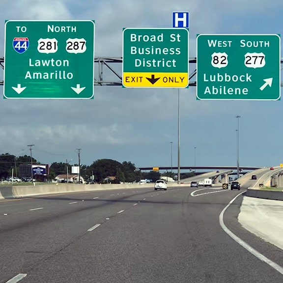
​Today US 281 and US 287 run along newer freeways, but formerly the two routes joined on surface roads through the downtown area, as shown in this historic photo:
Picture

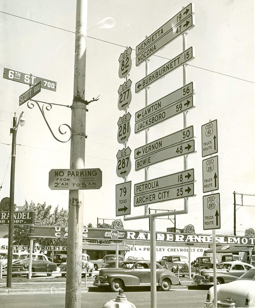
​Not far from there, between Vernon and Oklaunion TX, US 287 and US 183 share a nine-mile overlap.  This concurrency also includes US 70, which makes it interesting because the three routes are signposted with three different cardinal directions:
Picture

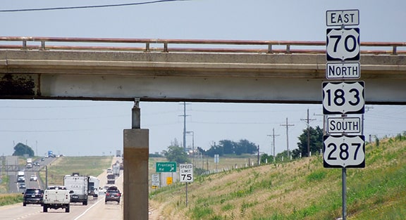
​Continuing to the northwest, US 287 intersects US 385, and in fact shares a 95-mile-long overlap with it between Boise City OK and Lamar CO:
Picture

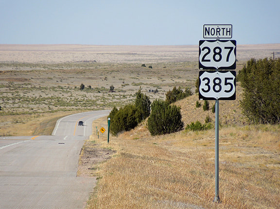
​Approximately in the middle of that overlapping segment, US 287-385 intersects US 160 at the south edge of Springfield CO:
Picture

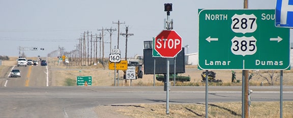
​And finally, much farther to the northwest, US 287 joins with US 191 at Moran Jct. WY:
Picture
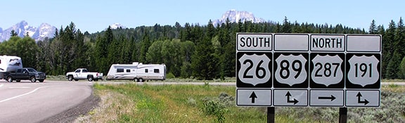
(Chris Elbert photo)

The two routes share pavement for 104 miles, not diverging again until a few miles north of West Yellowstone MT (although about 67 of those miles are on a segment that passes through Yellowstone National Park, where US routes are not signposted and technically do not exist).
1 Comment
Herbert Savage link
2/3/2025 05:19:20 pm

Nice maps. Too bad you didn't label the highways.

Reply

Your comment will be posted after it is approved.


Leave a Reply.

    RSS Feed

    Author

    This guy.

    Categories

    All
    Alabama
    Arizona
    Boston
    California
    Colorado
    Denver
    Florida
    Geo-center
    Geography
    Historic
    Idaho
    Illinois
    Indiana
    Kansas
    Kentucky
    Maryland
    Massachusetts
    Michigan
    Midpoint
    Mileage
    Minnesota
    Missouri
    Nebraska
    New Hampshire
    New Jersey
    New Mexico
    Newport
    New York
    North Carolina
    North Dakota
    Numbering
    Oddity
    Ohio
    Oklahoma
    Oregon
    Pennsylvania
    Proposed
    Renumbering
    Signage
    South Carolina
    South Dakota
    Tennessee
    Texas
    Updates
    US 101
    US 127
    US 13
    US 136
    US 150
    US 154
    US 16
    US 160
    US 163
    US 164
    US 169
    US 177
    US 180
    US 183
    US 190
    US 191
    US 20
    US 210
    US 212
    US 218
    US 220
    US 23
    US 231
    US 24
    US 241
    US 25
    US 259
    US 26
    US 266
    US 27
    US 270
    US 271
    US 277
    US 281
    US 283
    US 285
    US 287
    US 3
    US 31
    US 311
    US 321
    US 331
    US 34
    US 36
    US 360
    US 371
    US 377
    US 383
    US 385
    US 40
    US 400
    US 411
    US 431
    US 450
    US 46
    US 48
    US 491
    US 50
    US 530
    US 55
    US 59
    US 6
    US 60
    US 61
    US 62
    US 63
    US 65
    US 66
    US 666
    US 67
    US 730
    US 74
    US 77
    US 80
    US 81
    US 83
    US 84
    US 85
    US 87
    US 89
    US 93
    US 94
    US 96
    US 99
    Utah
    Virginia
    Washington
    Watersheds
    West Virginia
    Wyoming

    Archives

    April 2025
    July 2024
    August 2023
    May 2023
    March 2023
    February 2023
    January 2023
    August 2022
    March 2022
    February 2022
    January 2022
    August 2021
    July 2021
    June 2021
    April 2021
    February 2021
    January 2021
    August 2020
    July 2020
    May 2020
    April 2020
    March 2020
    February 2020
    January 2020
    December 2019
    October 2019
    September 2019
    August 2019
    May 2019
    January 2019
    November 2018
    June 2018
    April 2018
    March 2018
    November 2017
    September 2017
    August 2017
    June 2017
    March 2017
    February 2017
    January 2017
    December 2016

Copyright © 1998-2025
Picture