US Ends .com
  • Home
  • Store
    • US highway book
    • US highway map
    • Florida US highway map
  • Endpoints
    • US 1 - US 9 >
      • 1 >
        • 201
        • 301
        • 401 [i]
        • 401 [ii]
        • 401
        • 501
        • 601
        • 701
      • 2w >
        • 102
      • 2e >
        • 202
        • 302
      • 3
      • 4 >
        • 104
      • 5
      • 6 >
        • 106
        • 206
      • 7
      • 8
      • 9 >
        • 109*
        • 209
        • 309
    • US 10 - US 19 >
      • 10 >
        • 110
        • 210
        • 310
        • 410
      • 11 >
        • 111
        • 211
        • 311
        • 411 [i]
        • 411 [ii]
        • 411
        • 511*
        • 611
        • 711*
      • 12 >
        • 112
        • 212
        • 312
      • 13 >
        • 113
        • 213
      • 14
      • 15
      • 16 >
        • 116
        • 216
      • 17 >
        • 17-1
        • 117 [i]
        • 117
        • 217
      • 18 >
        • 118
        • 218
      • 19 >
        • 119
        • 219
        • 319
    • US 20 - US 29 >
      • 20e >
        • 120
        • 220
        • 320
        • 420
      • 20w
      • 21 >
        • 121 [i]
        • 121
        • 221
        • 321
        • 421
        • 521
      • 22 >
        • 122 [i]
        • 122 [ii]
        • 222
        • 322
        • 422e
        • 422w
        • 522
        • 622*
      • 23 >
        • 123 [i]
        • 123
        • 223
      • 24 >
        • 124
        • 224
      • 25
      • 26 >
        • 126
      • 27 >
        • 127
        • 227
      • 28
      • 29 >
        • 129
    • US 30 - US 39 >
      • 30 >
        • 130
        • 230
        • 330
        • 430
        • 530
        • 630*
        • 730
        • 830
      • 31 >
        • 131
        • 231
        • 331 [i]
        • 331
        • 431
      • 32
      • 33
      • 34
      • 35
      • 36 >
        • 136
      • 38 >
        • 138
    • US 40 - US 49 >
      • 40 >
        • 140
        • 240
        • 340
      • 41 >
        • 141
        • 241 [i]
        • 241 [ii]
        • 341
        • 441 >
          • 441n
          • 441s
        • 541
        • 641
      • 42
      • 43
      • 44
      • 45
      • 46
      • 48 [i]
      • 48 [ii]
      • 48
      • 49
    • US 50 - US 59 >
      • 50 >
        • 150
        • 250
        • 350
        • 450
        • 550
        • 650
      • 51 - 55 >
        • 51 >
          • 151
        • 52 >
          • 152
        • 53
        • 54 >
          • 154
        • 55
      • 56 >
        • 156
      • 57
      • 58 >
        • 158
        • 258
      • 59 >
        • 159
        • 259
    • US 60 - US 69 >
      • 60 >
        • 160
        • 260
        • 360
        • 460
      • 61 - 65 >
        • 61 >
          • 161
        • 62
        • 63 >
          • 163 [i]
        • 64 >
          • 164 [i]
          • 164 [ii]
          • 264
        • 65 >
          • 165
      • 66 >
        • 166
        • 266
        • 366 [i]
        • 366 [ii]
        • 466 [i]*
        • 466 [ii]
        • 566
        • 666
      • 67 >
        • 167
      • 68 >
        • 168
      • 69 >
        • 169
    • US 70 - US 79 >
      • 70 >
        • 170
        • 270 [i]*
        • 270
        • 370
        • 470
      • 71 >
        • 171
        • 271
        • 371 [i]
        • 371 [ii]
        • 371
      • 72 - 76 >
        • 72
        • 73
        • 74
        • 75 >
          • 175
          • 275
        • 76 >
          • 176
          • 276
      • 77 >
        • 177
        • 277
        • 377
      • 78 >
        • 178
        • 278
        • 378
      • 79
    • US 80 - US 89 >
      • 80 - 84 >
        • 80 >
          • 180 [i]
          • 180
          • 280
          • 380
        • 81 >
          • 181
          • 281
        • 82
        • 83 >
          • 183
          • 283
          • 383
        • 84
      • 85 - 89 >
        • 85 >
          • 185
          • 285 [i]
          • 285
          • 385 [i]
          • 385
          • 485
        • 87 >
          • 187
          • 287n
          • 287s
        • 89n
        • 89s >
          • 189 [i]
          • 189
    • US 90 - US 99 >
      • 90 - 94 >
        • 90 >
          • 190
          • 290
        • 91 >
          • 191 >
            • 191n
            • 191s
          • 491
        • 92 >
          • 192
        • 93
        • 94
      • 95 -98 >
        • 95 >
          • 195
          • 295
          • 395
        • 96 [i]
        • 96
        • 97 >
          • 197
        • 98
      • 99 >
        • 199
        • 299
        • 399
    • Anomalies >
      • 101
      • 163
      • 400
      • 412
      • 425
  • Places
    • A-L >
      • A >
        • Aberdeen
        • Albuquerque
        • Amarillo
        • Apalachicola
        • Astoria
        • Atlantic
      • B >
        • Baltimore
        • Baton Rouge
        • Bay Area
        • Bishop
        • Boone
        • Brady
        • Bristol
        • Brownsville
        • Brunswick
      • C >
        • Charleston
        • Chattanooga
        • Chicago
        • Cincinnati
        • Cleveland
        • Cody
        • Corpus
        • Cortez
        • Council Bluffs
        • Covington
        • Crescent
        • Cumberland Gap
      • D-E >
        • Dallas
        • Des Moines
        • Detroit
        • Dothan
        • Douglas
        • El Paso
        • Erie
        • Eugene
      • F >
        • Farmington
        • Flagstaff
        • Florence
        • Fox Valley
        • Franklin
      • G >
        • Gallup
        • Georgetown
        • Grand Junction
        • Grand Portage
        • Grayling
        • Great Falls
        • Greeley
      • H-I >
        • Hardeeville
        • Harrisburg
        • Holbrook
        • Idaho Falls
        • Int'l Falls
      • J-K >
        • Jacksonville
        • Joplin
        • Junction
        • Kansas City
        • Keokuk
        • Key West
        • Kingman
      • L >
        • Laredo
        • Lewiston
        • Long Beach
        • Los Angeles
        • Louisville
        • Lubbock
    • M-R >
      • M >
        • Mackinaw
        • Madison
        • Maryhill
        • Maysville
        • Miami
        • Midway
        • Miles City
        • Milford
        • Milwaukee
        • Minneapolis
        • Mobile 31
        • Mobile 31-43-45
        • Montgomery
        • Monticello
        • Mount Vernon
      • N-O >
        • Nags Head
        • Naples
        • Natchez
        • New Castle
        • New Orleans
        • Niagara
        • Norlina
        • Ocean City
        • Oklahoma City
      • P >
        • Pee Dee
        • Pembina
        • Pensacola
        • Petersburg
        • Philadelphia
        • Piegan
        • Pineville
        • Port Arthur
        • Portsmouth
      • Q-R >
        • Quad Cities
        • Rapid City
        • Raton
        • Reading
        • Richmond
        • Rockingham
        • Rouses Point
    • S-Z >
      • S >
        • San Antonio
        • San Antonio NM
        • San Diego
        • Santa Fe
        • Savannah
        • Sioux
        • Springer
        • Springfield
        • St. Ignace
        • St. John
        • St. Paul
        • St. Pete
      • T-U-V >
        • Tallahassee
        • Tampa
        • Toledo
        • Trinidad
        • Tuba City
        • Ucolo
        • VA Beach
      • W >
        • Walterboro
        • Waverly
        • West Memphis
        • Wilmington
        • Wilson
        • Wrightsville
      • Y >
        • Yellowstone E
        • Yellowstone N
        • Yellowstone NE
        • Yellowstone S
        • Yellowstone W
  • Highways
    • Map of all endpoints
    • Sources
    • History
    • 1926 almost-routes
    • Intra-state routes
    • Numbering
    • Colors
    • Gaps
    • Blog
  • Bonus
    • Colorado >
      • Lowest point
      • Antipodes
      • Toponymy >
        • Roots
      • Colloquialisms
      • Populations
      • Denvers
    • Washington Meridian
    • Watersheds >
      • Headwaters Hill
      • Three Waters Mtn.
      • Parting of the Waters
    • Geo-centers >
      • 48 states
      • 50 states
      • North America
    • State corners >
      • AZ-CO-NM-UT
      • CO-UT-WY
      • CO-NE-WY
      • CO northeast
      • CO-KS-NE
      • CO-KS-OK
      • CO-NM-OK
      • NM-OK-TX
      • NM southeast
      • TX northwest
  • Connect
    • Author/history
    • Rationale
    • Contact
    • Contributors
    • Submissions

US Highways Blog

US 400: its number is not the only error

4/11/2018

12 Comments

 
Picture
The easternmost of US 400's many overlaps with other US routes.
On a recent roadtrip along US 400, my son asked me, "Isn't 400 kind of a weird number for a highway?"  Apparently even non-roadgeeks sense that there is something wrong with the US 400 designation.  But it goes beyond that.  This post examines all of the things that are wrong with US 400: not only its number, but also its purpose, its implementation, its intra-state nature, its collateral damage, and its amount of concurrent mileage with other US routes.  But I'm getting ahead of myself; let's start from the beginning...
History
In the early 1990s, Wichita leaders helped to convince the US DoT of the importance of an east-west interstate through the city, and the proposed route (I-66) was included among the "High Priority Corridors" of ISTEA legislation.  However, states to the west of Kansas offered no support, and some interests even expressed opposition.  To the east, most states could not justify the cost or generate enough interest, so eventually the idea was dropped.  Wichita would not be getting a new interstate after all, and it was back to the drawing board for KDoT.  The agency had three main goals:
  • West of Wichita, travel to Kansas' other two "southern tier" cities (Dodge City and Garden City) was accomplished via three designations: US 54, K-154, and US 50.  KDoT wanted a single route connecting these three cities.
  • East of Wichita, there was no direct connection to I-44, and the shortest route involved eight different designations: US 54 east; K-96 east to Fredonia; K-47 east to US 59, then south to Parsons; US 160 east to Pittsburg; US 69 and US 69A south to Baxter Springs; and finally US 166 east to I-44.  KDoT sought to give this corridor an identity by unifying it with a single route designation.
  • Even more important than the route designation was the desire to improve the route itself -- particularly this stair-stepping series of eight highways that provided a connection between Wichita and I-44.  At the time, the route between those two points involved several right-angle turns at stop signs and traffic lights, and it went right through the central business districts of a few towns, including Fredonia, Parsons, and Baxter Springs.  KDoT wanted a more efficient highway to facilitate travel between Wichita and I-44.
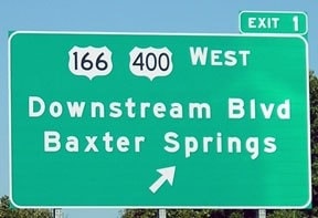
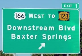
That last goal presented a challenge, because I-44 just misses the southeast corner of Kansas.  So the connection with the Interstate System had to be made in another state, namely Missouri.  It was probably for this reason that KDoT requested a US route number for their corridor (rather than simply using a state route designation).  AASHTO not only granted their request, but reportedly they also let KDoT choose the number from a list of available options.  Thus the US 400 designation was born in 1994.  
An (essentially) intra-state US route
Way back in 1937, AASHO (as it was known back then) adopted a policy stating that "
No new U. S. route located wholly in one State shall be established."  57 years later, when US 400 was originally commissioned, it went only as far west as Garden City.  So the route was entirely in Kansas, except for its easternmost segment, which went a fraction of a mile into Missouri.  Thus, while US 400 technically complied with the letter of the law, it certainly did not observe the intent.  
Picture
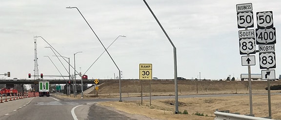
The original western terminus of US 400, at its junction with the US 83 bypass in Garden City.
Long overlaps with other US routes
At its commissioning, US 400's total length was 398 miles, but none of it was new construction.  Rather, the entire route was along existing highways, and 270 miles (or 68%) of its distance was concurrent with other US routes.  Two years later, the US 400 designation was extended 86 miles further west to its current terminus in Granada.  So then US 400 was 483 miles long, spanning the entire length of Kansas, and ending about 15 miles into Colorado.  But because the entirety of its extension was along US 50, that increased its redundant distance to 356 miles, or an astounding 74%. ​
Picture
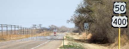
Western beginning of US 400's 131-mile concurrency with US 50.
At the time of US 400's inception, a 30-mile stretch was concurrent with US 160.  But about six years later, the routing of US 160 between Pittsburg and Independence was changed, eliminating most of its overlap with US 400 (more on this below, under "Collateral Damage").  In addition, a few changes have been made to the routing of US 400 itself:
  • Baxter Springs bypass (c. 2000)
  • New alignment between Parsons and Fall River, including Fredonia bypass (c. 2000)
  • Parsons bypass (c. 2005)
  • Dodge City bypass (c. 2010)
The net result is incrementally shorter mileage and a slight increase in solo pavement.  At the time of this writing (2018), the length of US 400 is down to 481 miles, but 305 miles are still shared with other US routes, or 63% of its total distance.

​If we zoom in a little closer and check out the western two-thirds of US 400, we observe that along the 321-mile stretch between Granada CO and Leon KS, US 400 has only two short standalone segments, totaling only 37 miles.  In other words, only 12% of western US 400 is solo pavement; the remaining 88% is piggybacked with other US routes.  ​With that much redundancy, one might well question why there was ever a need for US 400.
Picture
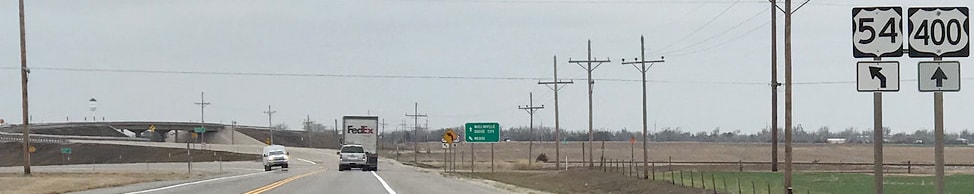
Western end of US 400's 144-mile concurrency with US 54.
Collateral Damage
Referenced above was the c. 2000 reroute of US 160.  This was an irksome move, because that realignment increased the length of travel along US 160 by seven miles.  Apparently KDoT decided the 30-mile overlap with US 400 was somehow wasteful, and they figured they could put the US 160 designation to better use by running it through the former K-96 corridor.  But now US 160 jumps around so much that it resembles the line on a habitual liar's polygraph.  Nobody would have a reason to follow US 160 between Pittsburg and Independence anymore.  The reroute made absolutely no sense, and no one would have even considered it if US 400 had not been run along US 160's former alignment.
Number
The number "400" is not compliant with US route numbering principles.  It implies that the route is either a branch of US highway Zero (which does not exist), or else a sibling route to US 100, US 200, or US 300 (none of which exist either).  Making it even worse is the fact that this was not just some misguided idea that Kansas came up with.  No, AASHTO actually 
offered this number to KDoT.  In other words: the organization that is ostensibly the guardian of the integrity of the US highway system gave its blessing to this completely nonsensical number.  
Implementation
In light of all these disqualifications according to its own policies, why was AASHTO willing to overlook all of that, and instead proceed with approving a US highway designation for this route?  Perhaps it was viewed as a sort of consolation prize to Wichita, to make up for their failed interstate bid.  But whatever the reason, it should not have been enough to justify the implementation of a route that violated so many of the expectations for a US highway.
Purpose 
Let's face it: US 400 is a Kansas intra-state route.  True, it does cross into Missouri... but only for a fraction of a mile, and only to connect with I-44.  The US 400 designation was never intended to provide any benefit to Missouri.  To begin with, the entire Missouri segment of the route already held a US highway designation (US 166).  And clearly KDoT was not interested in providing a connection between Wichita and a Missouri population center, namely Joplin or Springfield.  Rather, they wanted an all-Kansas corridor with a connection to the interstate system.  That is the only way to explain why the route takes such a drastic turn to the south, through the extreme southeast corner of Kansas, instead of providing a more direct connection with one of those Missouri cities.

It is also true that US 400 enters Colorado.  But originally that was not the case.  And, like Missouri, the entire Colorado segment is concurrent with another US route (US 50).  The most likely scenario in 1996 was that KDoT decided they wanted to extend their corridor all the way to their western border, but they assumed AASHTO would not have allowed a US route to terminate at a state line*, so they asked CDoT to jointly apply for a western extension of US 400.  Colorado agreed simply for the sake of being a good neighbor, but clearly CDoT has no use for the US 400 designation, as they terminate the route at the first US highway junction it encounters.
*this may have been an erroneous assumption, considering all of the other violations that AASHTO was willing to overlook with regard to US 400 designation.


So, to reiterate: US 400 is essentially a Kansas intra-state highway.  There is no reason to begrudge KDoT's right to unify their southern tier with a single highway designation.  But it did not have to be a US route designation.  In fact, it most certainly should not have been a US route.  For an intra-state corridor, the proper designation is a state highway.  KDoT could have chosen any designation they wanted; they did not need to involve AASHTO nor invoke the US highway system.  Let's say they decided on the number "123" for their state highway.  They could have ended it at the Colorado line, and no one would have blinked an eye.  
But how would K-123 be signed from I-44, since that interchange is in Missouri?  This is how US 400 is signed currently...
Picture
...but with just a little cooperation from Missouri, K-123 could have been signed like this:
Picture
To summarize, there are many things wrong with the US 400 designation, and it was not a worthy addition to the US highway system.  It should be decommissioned and replaced with a Kansas state highway designation.
Get your very own map showing all current and historic US routes!
Get your copy of this epic book that commemorates the first century of the US route system!
12 Comments
Nick Webster
4/29/2018 11:14:19 am

Two options: K-400, or K-789 (just to mess with Wyoming).

Reply
Dale Sanderson link
4/29/2018 12:30:27 pm

K-789, I love it! Yeah, now that US 400 has been a thing for almost 25 years, I agree, K-400 would make the most sense. But back in 1994, before the fateful decision had been made, I think the best choice would have been to extend the K-154 designation both directions (west from Dodge City, and east from Mullinville). Of course, that was historically US 154.

Reply
Alan Peterson
6/19/2021 11:26:22 pm

789 was meant to be a north-south route of state highways all bearing that number
from Mexico to Canada---presumably to promote traffic and tourism---but only Wyoming carried out its part of the deal.

Reply
David Sturm
8/18/2018 07:34:12 pm

I imagine with Colorado becoming more easygoing, if they'd just extend US 400 on to La Junta (maybe using 194 along the way just because), and then have it replaced CO 10 to Walsenburg, at least it would have a good finish to I-25 rather than evaporating in the plains of Colorado.

Reply
Alan Peterson
6/19/2021 11:18:05 pm

Agreed.

Reply
Mi Kil
7/18/2019 02:48:08 pm

I'm reminded of the CHI-KCY routing, that a new single unifying number was created, mostly over existing routes and roads.

but each state did their own state highway number, and made it the same in each state.

That certainly would have been more qualifying of a US-, or even I- (as most of it was on interstates) number!!!

but either they didn't apply, or they applied and was denied. And sorry to say, CHI or KCY are much bigger than Wichita ever will be!

I do also believe, that the route e-w on US 36 btwn Hannibal and Claycomo, just *might* someday become upgraded to continue as I-72.

So, just WHO in Wichita has sooooo much political clout - and transport one at that - that they could get such a US-route designation for, as you truly say, basically an intrastate route.

KS could have created its own state highway route number to be an overlay onto the mishmash of road numbers if they wanted to create an easier-to-follow route numbering.

See: https://en.wikipedia.org/wiki/Chicago–Kansas_City_Expressway

Reply
Alan Peterson
6/19/2021 11:16:31 pm

I just discovered US 400 today while looking at the part that coincides with US 50, and as I folIowed it across Kansas, I became increasingly puzzled---that is, why is this number here at all? I agree with those who say it's unnecessary. Having two numbers for the same road is both confusing and unnecessary, as well as a waste of money. And it's really odd that it just vanishes in Colorado at the junction with US 385. Not so much as a sign saying "End US 400"---it's just not there any more.

Reply
Mark Kostner
10/31/2021 12:04:26 pm

US 400 is a silly route. East of Wichita it ended up following K-96 and near Fredonia and Neodesha was given its own path and east of US 169 follows the route of the former US 160 which was rerouted onto the former 96 route on a new road past Parsons to Pittsburg.. The former K-96 which actually ran from west of Pueblo to Springfield was cut back in Kansas. The best way to i-44 from Pittsburg is K-171, which its name suggests, is the best connection to US 71, now I-49 at Joplin. US 400 is a lightly traveled route that 2 lanes seemed to handle well. West of Wichita, US 400 is only on its own once, connecting US 54 at Mullinville to US 50 at Dodge City on the former US 154. A more logical route would have been a US 450 following K-96 from Pueblo to Wichita via Hutchinson and on to Joplin to i-44 &49. Interestingly a short line railroad is cobbling several routes together to do just that for freight.. Or veering west from LaJunta to Walsenurg to hook up with US 160 to cross the Rockies would be a good western outlet for US 400. Nearby in Oklahoma is US 412, another route that makes no sense. As for Wichita, the only interstate that would have made any sense would have been US 54 to El Paso as a NAFTA corridor which bypassed the increasingly congested Central Texas but traffic is pretty light along it, too

Reply
Eric Hopp
12/3/2023 02:15:06 am

The Interstate Highway System also has an anomaly of US-400's nature with I-238. However, California settled on the number 238 as a continuation of its State Route 238 and couldn't pick an X80 designation because all the X80 options were already in use at the time according to CalTrans Highway Numbering Protocols!

(For the record, I-238 is a short connector highway between I-580 and I-880 in the San Francisco area.)

Reply
Eric Hopp
12/21/2023 07:45:52 pm

Specifically, the San Francisco Bay area. It's on the Oakland side of the bay.

Reply
Joseph Kerski link
5/29/2024 12:56:30 pm

As a geographer I've been on this highway several times and have always been bothered by the number. I wish it was US 58 or US 48 or something that would make more sense in this area given its location. Thanks for the additional history !

Reply
Benjamin Dias
6/9/2024 10:43:03 am

With all of the congressional actions in recent years, I'm surprised that they haven't tried to get a designation written into law. There are already several interstate-standard segments, including a direct connection with I-35, so an odd x35 could be designated at any time, but it would likely remain unsigned, just like 305 in California and 595 in Maryland.

Reply

Your comment will be posted after it is approved.


Leave a Reply.

    RSS Feed

    Author

    This guy.

    Categories

    All
    Alabama
    Arizona
    Boston
    California
    Colorado
    Denver
    Florida
    Geo-center
    Geography
    Historic
    Idaho
    Illinois
    Indiana
    Kansas
    Kentucky
    Maryland
    Massachusetts
    Michigan
    Midpoint
    Mileage
    Minnesota
    Missouri
    Nebraska
    New Hampshire
    New Jersey
    New Mexico
    Newport
    New York
    North Carolina
    North Dakota
    Numbering
    Oddity
    Ohio
    Oklahoma
    Oregon
    Pennsylvania
    Proposed
    Renumbering
    Signage
    South Carolina
    South Dakota
    Tennessee
    Texas
    Updates
    US 101
    US 127
    US 13
    US 136
    US 150
    US 154
    US 16
    US 160
    US 163
    US 164
    US 169
    US 177
    US 180
    US 183
    US 190
    US 191
    US 20
    US 210
    US 212
    US 218
    US 220
    US 23
    US 231
    US 24
    US 241
    US 25
    US 259
    US 26
    US 266
    US 27
    US 270
    US 271
    US 277
    US 281
    US 283
    US 285
    US 287
    US 3
    US 31
    US 311
    US 321
    US 331
    US 34
    US 36
    US 360
    US 371
    US 377
    US 383
    US 385
    US 40
    US 400
    US 411
    US 431
    US 450
    US 46
    US 48
    US 491
    US 50
    US 530
    US 55
    US 59
    US 6
    US 60
    US 61
    US 62
    US 63
    US 65
    US 66
    US 666
    US 67
    US 730
    US 74
    US 77
    US 80
    US 81
    US 83
    US 84
    US 85
    US 87
    US 89
    US 93
    US 94
    US 96
    US 99
    Utah
    Virginia
    Washington
    Watersheds
    West Virginia
    Wyoming

    Archives

    April 2025
    July 2024
    August 2023
    May 2023
    March 2023
    February 2023
    January 2023
    August 2022
    March 2022
    February 2022
    January 2022
    August 2021
    July 2021
    June 2021
    April 2021
    February 2021
    January 2021
    August 2020
    July 2020
    May 2020
    April 2020
    March 2020
    February 2020
    January 2020
    December 2019
    October 2019
    September 2019
    August 2019
    May 2019
    January 2019
    November 2018
    June 2018
    April 2018
    March 2018
    November 2017
    September 2017
    August 2017
    June 2017
    March 2017
    February 2017
    January 2017
    December 2016

Copyright © 1998-2025
Picture