US Ends .com
  • Home
  • Store
    • US highway book
    • US highway map
    • Florida US highway map
  • Endpoints
    • US 1 - US 9 >
      • 1 >
        • 201
        • 301
        • 401 [i]
        • 401 [ii]
        • 401
        • 501
        • 601
        • 701
      • 2w >
        • 102
      • 2e >
        • 202
        • 302
      • 3
      • 4 >
        • 104
      • 5
      • 6 >
        • 106
        • 206
      • 7
      • 8
      • 9 >
        • 109*
        • 209
        • 309
    • US 10 - US 19 >
      • 10 >
        • 110
        • 210
        • 310
        • 410
      • 11 >
        • 111
        • 211
        • 311
        • 411 [i]
        • 411 [ii]
        • 411
        • 511*
        • 611
        • 711*
      • 12 >
        • 112
        • 212
        • 312
      • 13 >
        • 113
        • 213
      • 14
      • 15
      • 16 >
        • 116
        • 216
      • 17 >
        • 17-1
        • 117 [i]
        • 117
        • 217
      • 18 >
        • 118
        • 218
      • 19 >
        • 119
        • 219
        • 319
    • US 20 - US 29 >
      • 20e >
        • 120
        • 220
        • 320
        • 420
      • 20w
      • 21 >
        • 121 [i]
        • 121
        • 221
        • 321
        • 421
        • 521
      • 22 >
        • 122 [i]
        • 122 [ii]
        • 222
        • 322
        • 422e
        • 422w
        • 522
        • 622*
      • 23 >
        • 123 [i]
        • 123
        • 223
      • 24 >
        • 124
        • 224
      • 25
      • 26 >
        • 126
      • 27 >
        • 127
        • 227
      • 28
      • 29 >
        • 129
    • US 30 - US 39 >
      • 30 >
        • 130
        • 230
        • 330
        • 430
        • 530
        • 630*
        • 730
        • 830
      • 31 >
        • 131
        • 231
        • 331 [i]
        • 331
        • 431
      • 32
      • 33
      • 34
      • 35
      • 36 >
        • 136
      • 38 >
        • 138
    • US 40 - US 49 >
      • 40 >
        • 140
        • 240
        • 340
      • 41 >
        • 141
        • 241 [i]
        • 241 [ii]
        • 341
        • 441 >
          • 441n
          • 441s
        • 541
        • 641
      • 42
      • 43
      • 44
      • 45
      • 46
      • 48 [i]
      • 48 [ii]
      • 48
      • 49
    • US 50 - US 59 >
      • 50 >
        • 150
        • 250
        • 350
        • 450
        • 550
        • 650
      • 51 - 55 >
        • 51 >
          • 151
        • 52 >
          • 152
        • 53
        • 54 >
          • 154
        • 55
      • 56 >
        • 156
      • 57
      • 58 >
        • 158
        • 258
      • 59 >
        • 159
        • 259
    • US 60 - US 69 >
      • 60 >
        • 160
        • 260
        • 360
        • 460
      • 61 - 65 >
        • 61 >
          • 161
        • 62
        • 63 >
          • 163 [i]
        • 64 >
          • 164 [i]
          • 164 [ii]
          • 264
        • 65 >
          • 165
      • 66 >
        • 166
        • 266
        • 366 [i]
        • 366 [ii]
        • 466 [i]*
        • 466 [ii]
        • 566
        • 666
      • 67 >
        • 167
      • 68 >
        • 168
      • 69 >
        • 169
    • US 70 - US 79 >
      • 70 >
        • 170
        • 270 [i]*
        • 270
        • 370
        • 470
      • 71 >
        • 171
        • 271
        • 371 [i]
        • 371 [ii]
        • 371
      • 72 - 76 >
        • 72
        • 73
        • 74
        • 75 >
          • 175
          • 275
        • 76 >
          • 176
          • 276
      • 77 >
        • 177
        • 277
        • 377
      • 78 >
        • 178
        • 278
        • 378
      • 79
    • US 80 - US 89 >
      • 80 - 84 >
        • 80 >
          • 180 [i]
          • 180
          • 280
          • 380
        • 81 >
          • 181
          • 281
        • 82
        • 83 >
          • 183
          • 283
          • 383
        • 84
      • 85 - 89 >
        • 85 >
          • 185
          • 285 [i]
          • 285
          • 385 [i]
          • 385
          • 485
        • 87 >
          • 187
          • 287n
          • 287s
        • 89n
        • 89s >
          • 189 [i]
          • 189
    • US 90 - US 99 >
      • 90 - 94 >
        • 90 >
          • 190
          • 290
        • 91 >
          • 191 >
            • 191n
            • 191s
          • 491
        • 92 >
          • 192
        • 93
        • 94
      • 95 -98 >
        • 95 >
          • 195
          • 295
          • 395
        • 96 [i]
        • 96
        • 97 >
          • 197
        • 98
      • 99 >
        • 199
        • 299
        • 399
    • Anomalies >
      • 101
      • 163
      • 400
      • 412
      • 425
  • Places
    • A-L >
      • A >
        • Aberdeen
        • Albuquerque
        • Amarillo
        • Apalachicola
        • Astoria
        • Atlantic
      • B >
        • Baltimore
        • Baton Rouge
        • Bay Area
        • Bishop
        • Boone
        • Brady
        • Bristol
        • Brownsville
        • Brunswick
      • C >
        • Charleston
        • Chattanooga
        • Chicago
        • Cincinnati
        • Cleveland
        • Cody
        • Corpus
        • Cortez
        • Council Bluffs
        • Covington
        • Crescent
        • Cumberland Gap
      • D-E >
        • Dallas
        • Des Moines
        • Detroit
        • Dothan
        • Douglas
        • El Paso
        • Erie
        • Eugene
      • F >
        • Farmington
        • Flagstaff
        • Florence
        • Fox Valley
        • Franklin
      • G >
        • Gallup
        • Georgetown
        • Grand Junction
        • Grand Portage
        • Grayling
        • Great Falls
        • Greeley
      • H-I >
        • Hardeeville
        • Harrisburg
        • Holbrook
        • Idaho Falls
        • Int'l Falls
      • J-K >
        • Jacksonville
        • Joplin
        • Junction
        • Kansas City
        • Keokuk
        • Key West
        • Kingman
      • L >
        • Laredo
        • Lewiston
        • Long Beach
        • Los Angeles
        • Louisville
        • Lubbock
    • M-R >
      • M >
        • Mackinaw
        • Madison
        • Maryhill
        • Maysville
        • Miami
        • Midway
        • Miles City
        • Milford
        • Milwaukee
        • Minneapolis
        • Mobile 31
        • Mobile 31-43-45
        • Montgomery
        • Monticello
        • Mount Vernon
      • N-O >
        • Nags Head
        • Naples
        • Natchez
        • New Castle
        • New Orleans
        • Niagara
        • Norlina
        • Ocean City
        • Oklahoma City
      • P >
        • Pee Dee
        • Pembina
        • Pensacola
        • Petersburg
        • Philadelphia
        • Piegan
        • Pineville
        • Port Arthur
        • Portsmouth
      • Q-R >
        • Quad Cities
        • Rapid City
        • Raton
        • Reading
        • Richmond
        • Rockingham
        • Rouses Point
    • S-Z >
      • S >
        • San Antonio
        • San Antonio NM
        • San Diego
        • Santa Fe
        • Savannah
        • Sioux
        • Springer
        • Springfield
        • St. Ignace
        • St. John
        • St. Paul
        • St. Pete
      • T-U-V >
        • Tallahassee
        • Tampa
        • Toledo
        • Trinidad
        • Tuba City
        • Ucolo
        • VA Beach
      • W >
        • Walterboro
        • Waverly
        • West Memphis
        • Wilmington
        • Wilson
        • Wrightsville
      • Y >
        • Yellowstone E
        • Yellowstone N
        • Yellowstone NE
        • Yellowstone S
        • Yellowstone W
  • Highways
    • Map of all endpoints
    • Sources
    • History
    • 1926 almost-routes
    • Intra-state routes
    • Numbering
    • Colors
    • Gaps
    • Blog
  • Bonus
    • Colorado >
      • Lowest point
      • Antipodes
      • Toponymy >
        • Roots
      • Colloquialisms
      • Populations
      • Denvers
    • Washington Meridian
    • Watersheds >
      • Headwaters Hill
      • Three Waters Mtn.
      • Parting of the Waters
    • Geo-centers >
      • 48 states
      • 50 states
      • North America
    • State corners >
      • AZ-CO-NM-UT
      • CO-UT-WY
      • CO-NE-WY
      • CO northeast
      • CO-KS-NE
      • CO-KS-OK
      • CO-NM-OK
      • NM-OK-TX
      • NM southeast
      • TX northwest
  • Connect
    • Author/history
    • Rationale
    • Contact
    • Contributors
    • Submissions

US Highways Blog

All about the shortest US routes

1/7/2022

2 Comments

 
(last updated 12/9/2023)
​Lots of people (myself included) have an odd fascination with the superlatives of just about any topic.  As it relates to highways, a common question is "What is the longest US route?"  (answer)  And then related questions branch off from there:
  • What was the longest US route historically?  (answer)
  • What is the longest north-south US route?  (answer)
  • What is the longest 3-digit US route?  (answer)
  • What is the longest 3-digit US route that runs east-west?  (answer)
Eventually the questions start swinging around to the opposite extreme, and those are the topics of this post.  Specifically we set out to answer these questions:
  • What is the shortest US route?
  • What was the shortest US route historically?
  • What is the shortest 2-digit US route?
  • What was the shortest 2-digit US route historically?
But first, a caveat: this article only takes mainline US routes into consideration.  There are lots of bannered US routes (e.g. Business US xx, or Spur US xx) that are very short (some even less than a mile).  There are also suffixed US routes (e.g. US xxA, or US xxN) that are very short.  But none of those are mainline US routes; rather they are all auxiliary US routes (i.e. their numbers are the same as the mainline route to which they connect).  This article excludes bannered and suffixed US routes, and focuses only on mainline US routes.
Get your very own map showing all current and historic US routes!
Get your copy of this epic book that commemorates the first century of the US route system!

The shortest US route, currently
In AASTHO's most recent route log (1989), two routes were listed at 42 miles each: US 266 and US 730.  However, the mileages published by AASHTO were rounded to the nearest integer, and were therefore subject to a non-trivial error margin.  Using a more precise method of measuring, we find that US 266 is 43.1 miles in length, while US 730 is only 41.3 miles long.  So currently US 730 is the shortest US highway.

The shortest US route, future
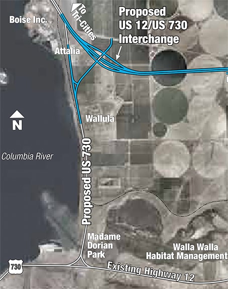
The difference between US 730 and US 266 is less than two miles.  Washington State DOT has planned a change in the alignment of US 12, which will presumably create a need to extend the US 730 designation by at least three more miles in length.  This WSDOT map illustrates their plan to extend US 730 northward along current US 12 to a junction with the new US 12:
Picture
Assuming that project gets completed, one collateral result will likely be that US 266 becomes the shortest mainline US route.

The shortest US route, historically
Among highway historians it is sometimes claimed that US 630 was the shortest-ever mainline US route.  And that would have been true... if US 630 had been an actual route.  It showed up on the Nov. 1926 map of official US routes approved by AASHO (now AASHTO), so it was definitely planned.  If we measure its intended route, it would have been only 2.9 miles long.  How does our modern measurement compare to the length of US 630 as listed on the early route logs?  Well... turns out it never appeared on any route logs.  By the time AASHO published their first US route log just a few months later (Apr. 1927), US 630 was already gone.  Why?  Because Idaho and Oregon objected; they wanted that short segment to be part of a longer auxiliary route that they signposted as US 30N (more details on this page).  So US 630 was never signposted, and therefore it doesn't count as a "real" US route.  

​Well then, what was the shortest "real" US route?  In AASHO's Apr. 1927 route log, US 530 was the shortest route listed, at 25 miles:
Picture
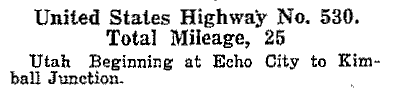
US 430 was listed at 37 miles, but I am quite certain that was a mistake.  US 430 was described as going from Crystal Lake to Aurora, but every map I have seen indicates that its true south end was in Geneva.  At the time, eastbound US 30 came into Geneva, then south to Aurora, then southeast to Joliet, so there was no reason for US 430 to be dual-signed with US 30 between Geneva and Aurora.  So if we look at US 430's actual mileage from Geneva to Crystal Lake, it was really only 25 miles long.  And it gets even more interesting: in 1933, US 14 was extended east from Winona MN into Chicago.  Its Illinois segment was routed along part of US 430 (the part between Crystal Lake and West Dundee).  So the 1933 issue (and only that issue) of Illinois' official state highway map showed that US 430 had been truncated to West Dundee, which left its total length at only 16 miles.  However, AASHO never authorized that truncation, and at any rate the following year Illinois extended US 330 such that it subsumed the remainder of US 430.  So can we say the unauthorized and very brief 16-mile iteration of US 430 was the shortest US route?  I think it's debatable, but at least worth mentioning.
Back to the 1927 route log, it should also be noted that there were a few other routes right on the heels of US 530.  Here are the shortest five on that list:
  • US 530: 25 miles
  • US 320: 26 miles
  • US 730: 26 miles (originally it went from Wallula Jct. only to Umatilla)
  • US 154: 27 miles
  • US 650: 27 miles
The next AASHO route log was from 1929.  In that log, it was US 154 (not US 530) that was indicated as the shortest.  These were the shortest five, as listed...
  • US 154: 21 miles
  • US 530: 24 miles
  • US 320: 27 miles
  • US 650: 27 miles
  • US 730: 27 miles
...however, it is very unlikely that US 154 was suddenly six miles shorter, especially in light of the fact that the next route log had it back at 30 miles (see below).  So it is almost certain that US 154's listing in the 1929 route log contained a typo; the correct mileage was actually still 27 miles.  If so, then US 530 was still the shortest.
The next three route logs (1932, 1934, and 1935) each contained identical information, listing only four routes at less than 30 miles:
  • US 530: 22 miles
  • US 320: 27 miles
  • US 650: 27 miles (gone by 1935 log)
  • US 730: 27 miles
  • US 154 was listed at 30 miles, along with three other routes (US 110, US 177, and US 189).
  • US 159 was commissioned a few months after the 1935 log was published (more about that route below).
So it is pretty clear that US 530 was the shortest mainline US route ever... or at least the shortest legitimate US route.  But for how many years was that true?  And did any other US routes hold the title after US 530 but before US 730?
Timeline: the shortest mainline US routes
US 530 remained the shortest US route until 1938, which is when its designation was replaced with a segment of the new US 189(ii).  But a few other very short routes were also decommissioned at or near the same time, including US 320, US 366, US 110, and US 189(i).  So after 1938, a few other US routes claimed the dubious honor for varying lengths of time.  Here is a full timeline:
  • In 1926, and for the next 12 years, US 530 was the shortest at 22 miles (it was decommissioned in 1938).
  • From 1933-1934, an unauthorized iteration of US 430 was only 16 miles long, causing a brief asterisk in US 530's reign.
  • In 1938, and for the next four years, US 159 took over as the shortest route, at 24.8 miles.
  • Also in 1938, US 320 and US 730 were tied for second-shortest at 27 miles, but US 320 was decommissioned in 1939.  US 730 remained at 27 miles until it was extended in 1942, but it did not become the shortest route during that time, because US 159 was not extended until the same year (1942).
  • In 1942*, and for nearly the next four decades, US 154 became the shortest US route at 36 miles, until it was decommissioned in 1979.
  • In 1979, US 730 became the shortest at 41.3 miles, and that remains the case through the present.
  • At some point in the future, US 266 will likely become the shortest at 43.1 miles.

*US 177 was commissioned in 1928.  The 1929 route log listed it at 28 miles, and the 1935 log had it at 30 miles.  If those figures were correct, then US 177 would have been the shortest US route from 1942 (when US 159 and US 730 were extended) to 1964 (when US 177 was extended).  However, the only way US 177 could have been that short is if it ended in Tonkawa.  But neither route log mentions Tonkawa; both list the south terminus as Three Sands Jct.  Furthermore, OKDoT maps from 1942-1964 clearly show US 177 extended south of Tonkawa, ending at Three Sands.  So US 177 could not have been only 30 miles long.  It actually would have been 40 miles long, and therefore would never have been the shortest US route.

What about the shortest two-digit US route?
So far this entire discussion has been about three-digit US routes.  These were originally envisioned to be shorter "child" routes that branched off from longer "parent" routes.  In other words, it is not all that surprising that some three-digit US routes are quite short. But since two-digit routes are presumed to be longer, which one is the shortest?

Currently, the 13th-shortest US highway is a two-digit route.  US 46 measures a surprisingly short 75 miles in length, and it is entirely in one state (although there is an interesting explanation for that).  
  • Currently there are 20 US highways with lengths less than 100 miles, and two of those are two-digit routes.
  • Currently there are 65 US highways of less than 300 miles, and 11 of those are two-digit routes.

What was the shortest two-digit US route historically?
In the 1927 route log, US 48 was the shortest two-digit route listed, at 67 miles...
Picture
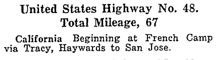
...and already by 1929, US 48 had been truncated on both ends, such that it was then only 50 miles long:
Picture
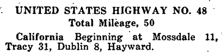
That was the shortest-ever two-digit US route.  But US 48 was decommissioned in 1931.  So what was the shortest two-digit US route after that?  In 1931, US 94 [Naples to Miami] became the shortest two-digit route at 110 miles.  (Incidentally, the next two shortest at the time were also east-west intra-state routes in Florida: US 92 at 163 miles [Tampa to Daytona], and US 98 at 193 miles [Pensacola to Apalachicola]).  US 94 held the title for only five years, until US 46 was commissioned in 1936.  At that time US 46 became the shortest two-digit, and has remained so ever since.
2 Comments
Doug Moore
1/20/2022 02:01:14 am

What about the longest alt-routes? I'm close to alt US 90 in Texas, and it's the longest one I know of, but I haven't found a list of them all, sorted by length.

Reply
usends.com link
1/20/2022 10:36:50 am

Post #24 in this thread suggests that US 90A in TX is the longest US alternate route by a pretty safe margin: https://www.aaroads.com/forum/index.php?topic=18819.0

Reply

Your comment will be posted after it is approved.


Leave a Reply.

    RSS Feed

    Author

    This guy.

    Categories

    All
    Alabama
    Arizona
    Boston
    California
    Colorado
    Denver
    Florida
    Geo-center
    Geography
    Historic
    Idaho
    Illinois
    Indiana
    Kansas
    Kentucky
    Maryland
    Massachusetts
    Michigan
    Midpoint
    Mileage
    Minnesota
    Missouri
    Nebraska
    New Hampshire
    New Jersey
    New Mexico
    Newport
    New York
    North Carolina
    North Dakota
    Numbering
    Oddity
    Ohio
    Oklahoma
    Oregon
    Pennsylvania
    Proposed
    Renumbering
    Signage
    South Carolina
    South Dakota
    Tennessee
    Texas
    Updates
    US 101
    US 127
    US 13
    US 136
    US 150
    US 154
    US 16
    US 160
    US 163
    US 164
    US 169
    US 177
    US 180
    US 183
    US 190
    US 191
    US 20
    US 210
    US 212
    US 218
    US 220
    US 23
    US 231
    US 24
    US 241
    US 25
    US 259
    US 26
    US 266
    US 27
    US 270
    US 271
    US 277
    US 281
    US 283
    US 285
    US 287
    US 3
    US 31
    US 311
    US 321
    US 331
    US 34
    US 36
    US 360
    US 371
    US 377
    US 383
    US 385
    US 40
    US 400
    US 411
    US 431
    US 450
    US 46
    US 48
    US 491
    US 50
    US 530
    US 55
    US 59
    US 6
    US 60
    US 61
    US 62
    US 63
    US 65
    US 66
    US 666
    US 67
    US 730
    US 74
    US 77
    US 80
    US 81
    US 83
    US 84
    US 85
    US 87
    US 89
    US 93
    US 94
    US 96
    US 99
    Utah
    Virginia
    Washington
    Watersheds
    West Virginia
    Wyoming

    Archives

    April 2025
    July 2024
    August 2023
    May 2023
    March 2023
    February 2023
    January 2023
    August 2022
    March 2022
    February 2022
    January 2022
    August 2021
    July 2021
    June 2021
    April 2021
    February 2021
    January 2021
    August 2020
    July 2020
    May 2020
    April 2020
    March 2020
    February 2020
    January 2020
    December 2019
    October 2019
    September 2019
    August 2019
    May 2019
    January 2019
    November 2018
    June 2018
    April 2018
    March 2018
    November 2017
    September 2017
    August 2017
    June 2017
    March 2017
    February 2017
    January 2017
    December 2016

Copyright © 1998-2025
Picture