|
(last updated 6/19/2023)
Do you ever think about what was here, before you were here? Before we all were here, with all of our roads, neighborhoods, houses, parks, buildings? We could go way back, millions of years, when the area that would later be known as "Denver" was still submerged beneath the western edge of a vast interior sea. Or we could go back not quite as far, maybe just 200 or 300 years, to a time when the only humans living in this area were those who belonged to the local Native American tribes. As they went in search of game, or moved their camps from one place to another, they formed trails, particularly along the streams in the area. Settlers of European descent did not begin to arrive here in earnest until the 1850s, less than 200 years ago. The old Native American trail along the east bank of Cherry Creek started to be used by new groups of people, who referred to it as the Cherokee Trail, the Goodnight-Loving cattle trail, or the Denver-Santa Fe stage line.
5 Comments
Prior to I-25, there was a different main highway that connected Denver to several of the Northern Front Range cities in Colorado. The number of this highway has changed a few times during the past century, but its general corridor has remained the same: it still runs through Ft. Collins, Loveland, Berthoud, Longmont, Lafayette, Broomfield, Westminster, and Denver. Not all of those cities had even been established at the time of the 1916 map shown below, but the highway corridor running along the Northern Front Range is readily apparent (going forward I will refer to this road as the NFRH, for "North Front Range Highway"):
(last updated 12/9/2023)
Lots of people (myself included) have an odd fascination with the superlatives of just about any topic. As it relates to highways, a common question is "What is the longest US route?" (answer) And then related questions branch off from there:
The photo below was taken looking east along the international boundary between Canada (to the left) and the U.S. (right). The large structure (with the flags on top) is the Peace Arch, which straddles the border. (It is not square to the boundary line; rather it is situated at a slight diagonal that roughly matches the angle of the roads that run through here.) If you look closely, you can see three boundary obelisks in the foreground:
(Most recently updated 4/5/2022)
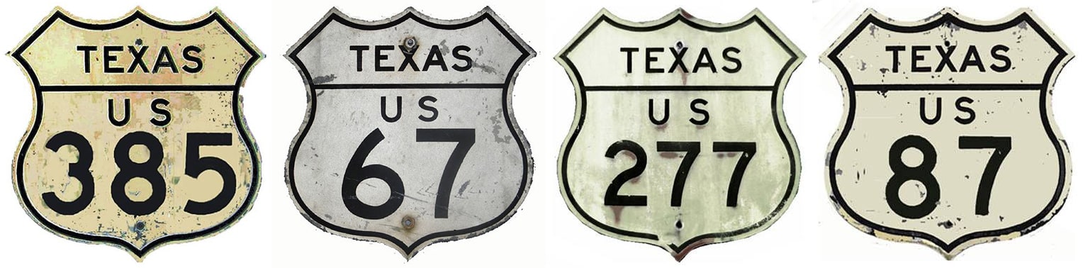
Shield images courtesy of Michael Summa
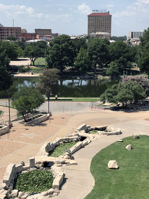
One of San Angelo's marketing slogans is "The Oasis of West Texas". This is not hyperbole; most approaches to the city are somewhat stark, so in contrast upon arrival in Angelo, one may well be pleasantly surprised at all of the rivers, reservoirs, trees and other vegetation:
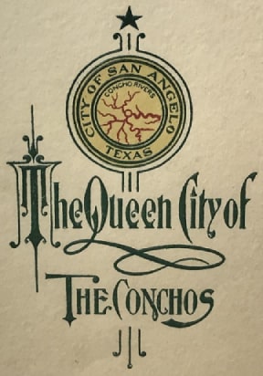
One of the city's other monikers is "The Pearl of the Conchos", which has a double meaning, referring to the freshwater Concho pearls that were historically harvested from area waterways. The three branches of the Concho River all converge in San Angelo; that was illustrated on this other slogan from days gone by:
On display at ASU's Mayer Museum, Jun. 2021
When the US highway system was inaugurated in late 1926, the only US route to initially serve San Angelo was US 385 (that is, the original US 385, not the current US 385). The new designation was added to Texas State Highway 9:
One of the many interesting things about this segment of US 34 is that it essentially follows the valley of the Colorado River between its headwaters in Rocky Mountain National Park and its confluence with the Fraser River in Granby. Consequently US 34 also provides access to all of the major water collection components of the Colorado-Big Thompson Project. Those include Grand Lake (Colorado's largest and deepest natural lake) and three artificial impoundments (Shadow Mountain Lake, Lake Granby, and Willow Creek Reservoir). Since there are many examples of highways which were originally built parallel to rivers, but which later had to be realigned because of water storage projects that were built in those valleys, I set out to explore whether US 34 had any historic alignments that existed prior to the reservoirs in the Middle Park area.
(Last updated 2/28/2023)
Of the "main" US highways (i.e. the one- and two-digit routes), the longest nine were all east-west routes (6, 20, 50, 30, 40, 60, 70, 80, 12). And if we take the longest 16 highways, only one of them is a north-south route (US 1, shown in red here): 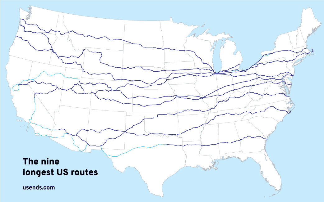
That stands to reason, because the United States is roughly twice as wide from east to west as it is from north to south. So it makes sense that there would be more long east-west routes.
From humble beginnings to great lengths
(last updated 11/27/2023)
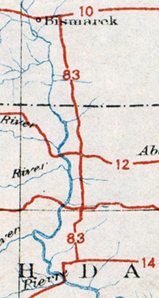
In 1925, when the US highway system was envisioned, there were plenty of proposed east-west routes crossing the Great Plains states, but there was a conspicuous lack of north-south routes between US 81 and US 85. This gap was about 300 miles wide in North Dakota, and it only increased to the south, until the gap was more like 500 miles wide in Texas. Obviously this was not an ideal situation for those six states, but a big obstacle prevented an easy remedy: there were very few decent-quality, long-distance, north-south roads through the Plains. One exception was the road between the capital cities of the two Dakotas. Those states petitioned AASHO for the US 83 designation, and by the time the US route system was officially inaugurated in 1926, their wish had been granted. For the next couple years, US 83 was a very short route -- only about 170 miles long -- running between Bismarck ND and Pierre SD:
However, by the early 1930s the US 83 designation had been extended not only north to the Canada border, but all the way down to the Mexico border too. This increased US 83's distance to nearly 1900 miles, and made it one of the longest north-south US routes. Additionally, as a result of US 83's new role as a trunk route, three newer US routes were numbered as branches of US 83. Two of these soon became quite lengthy themselves, and they still exist (US 183 and US 283). Just as these highways intertwine with each other, their history is also interrelated. This article examines the evolution of US 83, as well as the x83 routes that are part of its "family".
(most recently updated 5/25/2023)
In 2001 construction began on Denver's "T-Rex" project (TRansportation EXpansion). This involved widening I-25 and adding light-rail service along the corridor through the south metro area. It was a great investment benefitting Denver commuters, but one unfortunate casualty was the old Colorado and Southern Railway bridge over I-25 (and unmarked US 87), just north of Evans Avenue. The rail line had not been used for years, but its bridge was a cool landmark that provided a little extra character in south Denver. |
AuthorCategories
All
Archives
July 2024
|


 RSS Feed
Copyright © 1998-2024
