|
(last updated 10/3/2023)
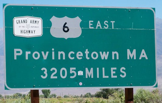
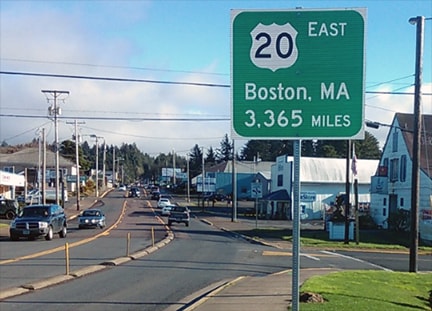
If you are familiar with the mileage signs posted at the terminus points of US 6 and US 20, you might point to those and say, "The answer is plain to see: US 20 is 160 miles longer than US 6."
If both of those signs were accurate, then obviously US 20 would be longer. But the fact is, only the US 6 sign is accurate, whereas the US 20 sign significantly overstates the true mileage. In reality, the mileages of the two routes are very close, and in fact there is every reason to believe US 6 is actually a slightly longer route.
8 Comments
One of the many interesting things about this segment of US 34 is that it essentially follows the valley of the Colorado River between its headwaters in Rocky Mountain National Park and its confluence with the Fraser River in Granby. Consequently US 34 also provides access to all of the major water collection components of the Colorado-Big Thompson Project. Those include Grand Lake (Colorado's largest and deepest natural lake) and three artificial impoundments (Shadow Mountain Lake, Lake Granby, and Willow Creek Reservoir). Since there are many examples of highways which were originally built parallel to rivers, but which later had to be realigned because of water storage projects that were built in those valleys, I set out to explore whether US 34 had any historic alignments that existed prior to the reservoirs in the Middle Park area.
US 411[i], US 121[i], US 117[i], Wilson, Wilmington NC, Pee Dee, Florence, US 21, US 170, US 421, US 3, Chattanooga, US 72, US 222, US 541, US 411, US 138, US 119, US 522, Brownsville, US 83 history, US 99, US 51, US 63, US 20, Wilmington DE, Cincinnati, US 22, US 124, US 136, US 150, US 152, US 8, US 264, US 501, US 27, US 104, US 441, Apalachicola, Intra-state routes, Wrong-way overlaps
|
AuthorCategories
All
Archives
July 2024
|

 RSS Feed
Copyright © 1998-2024
