|
US 10, US 72, US 180[ii], Mobile, Georgetown, US 78, US 601, US 164[i], US 20[w], US 197, US 730, US 275, Boone, Walterboro, Jacksonville, Waverly, US 119, US x83 family, US 127, Detroit, US 67, US 150, US 321, US 223, US 126, Brunswick, Bishop, US 395, US 99, US 95, US 60, US 93, US 180[I], US 70, US 250, Key West, US 212, US 11, US 38, US 280, US 74, US 130, US 50
0 Comments
Waverly, US 130, US 50, US 189, Bay Area, US 9, US 340, Ocean City, US 113, US 99, Single-state routes, US 166, US 177, Geographic center of TX, Longest TX state highways, US 212, Miami, US 61, US 266, US 377, US 167, US 123, US 385, US 176, US 378, Georgetown, US 341, Wrightsville, Chattanooga, US 22, Grand Junction, US 165, US 136, US 66, US 641, US 96, US 171, US 175, New Orleans, Port Arthur
(last updated 6/19/2023)
Do you ever think about what was here, before you were here? Before we all were here, with all of our roads, neighborhoods, houses, parks, buildings? We could go way back, millions of years, when the area that would later be known as "Denver" was still submerged beneath the western edge of a vast interior sea. Or we could go back not quite as far, maybe just 200 or 300 years, to a time when the only humans living in this area were those who belonged to the local Native American tribes. As they went in search of game, or moved their camps from one place to another, they formed trails, particularly along the streams in the area. Settlers of European descent did not begin to arrive here in earnest until the 1850s, less than 200 years ago. The old Native American trail along the east bank of Cherry Creek started to be used by new groups of people, who referred to it as the Cherokee Trail, the Goodnight-Loving cattle trail, or the Denver-Santa Fe stage line.
(most recently updated 5/18/2023)
Inspired by Kurumi in an AARoads Forum post, I decided to compile a list of US routes that have been completely moved (or at least mostly moved) from their original alignments. In other words, these routes bear no resemblance (or very little resemblance) to the route that originally carried the same number. A subset of these shape-shifting routes could be considered "Grandfather's Axe highways".
US 231 was included in the inaugural routes of Nov. 1926, but at the time it ran only from Montgomery AL to Marianna FL. US 241 was not among the original routes*, but neither was it far behind: it was commissioned in Mar. 1930. This was mostly done to appease certain Alabama interests who wanted a US route designation to be applied to their State Highway 1.
*For the sake of clarity, there actually was a US 241 that was commissioned in 1926 to run between Nashville TN and Hopkinsville KY. However, it was never signposted as such in Tennessee, and possibly not in Kentucky either. AASHO officially canceled the US 241[i] designation in Jun. 1929, and its number was recycled less than a year later and applied to the route discussed on this page. To avoid confusion, this route is sometimes differentiated as US 241[ii].
Gaps, US 20[e], US 20[w], US 441[n], US 441[s], US 287[n], US 287[s], US 89[n], US 89[s], US 191[n], US 191[s], US 63, US 66, US 10, US 311, Rouses Point, US 175, New Orleans, US 167, US 21, US 91, US 189[i], Jacksonville, US 92, US 151, US 79, US 270, Yellowstone NE, Cody, US 420, US 320, US 310, US 16, US 116, Rockingham, US 6, Covington, US 41, Brady, US 22, Bay Area, US 222
This post is for the sake of those who may not have caught the references on the home page. Those phrases are from the lyrics to a 1980 song by the Talking Heads titled "Once in a Lifetime". Here are the relevant stanzas:
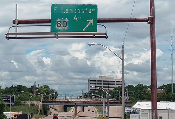
Historically US 80 connected Dallas and Ft. Worth. Although US 80 was decommissioned along that segment in 1993, some evidence of US 80's historical presence in Ft. Worth survived for nearly another three decades. This photo was taken looking north on Beach Street:
Charles Turner, Jun. 2016
(most recently updated 2/12/2024, after Super Bowl LVIII [58] was played)
When I was growing up in the 1970s, one of my favorite collections was a set of miniature plastic National Football League helmets. I recently happened to find them again, and now that nearly 50 years have passed, it is interesting to look back at what has changed in the NFL since then. During the '70s there were only 28 teams. So that was 14 teams per conference, which did not divide up very well. There were only three divisions in each conference, so two divisions consisted of five teams each, while one division consisted of four teams.
(last updated 9/6/2022)
1992 was the first time I went through Norton. At the time I was not yet what I would describe as a "roadgeek", but I still thought this sign was worth stopping for a photo: 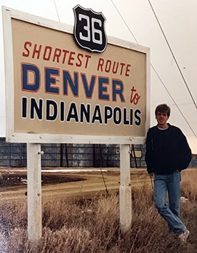
1992
|
AuthorCategories
All
Archives
July 2024
|

 RSS Feed
Copyright © 1998-2024
