|
From humble beginnings to great lengths
(last updated 11/27/2023)
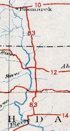
In 1925, when the US highway system was envisioned, there were plenty of proposed east-west routes crossing the Great Plains states, but there was a conspicuous lack of north-south routes between US 81 and US 85. This gap was about 300 miles wide in North Dakota, and it only increased to the south, until the gap was more like 500 miles wide in Texas. Obviously this was not an ideal situation for those six states, but a big obstacle prevented an easy remedy: there were very few decent-quality, long-distance, north-south roads through the Plains. One exception was the road between the capital cities of the two Dakotas. Those states petitioned AASHO for the US 83 designation, and by the time the US route system was officially inaugurated in 1926, their wish had been granted. For the next couple years, US 83 was a very short route -- only about 170 miles long -- running between Bismarck ND and Pierre SD:
However, by the early 1930s the US 83 designation had been extended not only north to the Canada border, but all the way down to the Mexico border too. This increased US 83's distance to nearly 1900 miles, and made it one of the longest north-south US routes. Additionally, as a result of US 83's new role as a trunk route, three newer US routes were numbered as branches of US 83. Two of these soon became quite lengthy themselves, and they still exist (US 183 and US 283). Just as these highways intertwine with each other, their history is also interrelated. This article examines the evolution of US 83, as well as the x83 routes that are part of its "family".
0 Comments
(last updated 6/22/2023)
The geo-center of Texas is roughly between Brownwood and Brady; the nearest locale is the minuscule burg of Mercury. Today US 377 is the closest major highway passing near the point, and a roadside historical marker is posted just south of Mercury: |
AuthorCategories
All
Archives
July 2024
|


 RSS Feed
