US Ends .com
  • Home
  • Store
    • US highway book
    • US highway map
    • Florida US highway map
  • Endpoints
    • US 1 - US 9 >
      • 1 >
        • 201
        • 301
        • 401 [i]
        • 401 [ii]
        • 401
        • 501
        • 601
        • 701
      • 2w >
        • 102
      • 2e >
        • 202
        • 302
      • 3
      • 4 >
        • 104
      • 5
      • 6 >
        • 106
        • 206
      • 7
      • 8
      • 9 >
        • 109*
        • 209
        • 309
    • US 10 - US 19 >
      • 10 >
        • 110
        • 210
        • 310
        • 410
      • 11 >
        • 111
        • 211
        • 311
        • 411 [i]
        • 411 [ii]
        • 411
        • 511*
        • 611
        • 711*
      • 12 >
        • 112
        • 212
        • 312
      • 13 >
        • 113
        • 213
      • 14
      • 15
      • 16 >
        • 116
        • 216
      • 17 >
        • 17-1
        • 117 [i]
        • 117
        • 217
      • 18 >
        • 118
        • 218
      • 19 >
        • 119
        • 219
        • 319
    • US 20 - US 29 >
      • 20e >
        • 120
        • 220
        • 320
        • 420
      • 20w
      • 21 >
        • 121 [i]
        • 121
        • 221
        • 321
        • 421
        • 521
      • 22 >
        • 122 [i]
        • 122 [ii]
        • 222
        • 322
        • 422e
        • 422w
        • 522
        • 622*
      • 23 >
        • 123 [i]
        • 123
        • 223
      • 24 >
        • 124
        • 224
      • 25
      • 26 >
        • 126
      • 27 >
        • 127
        • 227
      • 28
      • 29 >
        • 129
    • US 30 - US 39 >
      • 30 >
        • 130
        • 230
        • 330
        • 430
        • 530
        • 630*
        • 730
        • 830
      • 31 >
        • 131
        • 231
        • 331 [i]
        • 331
        • 431
      • 32
      • 33
      • 34
      • 35
      • 36 >
        • 136
      • 38 >
        • 138
    • US 40 - US 49 >
      • 40 >
        • 140
        • 240
        • 340
      • 41 >
        • 141
        • 241 [i]
        • 241 [ii]
        • 341
        • 441 >
          • 441n
          • 441s
        • 541
        • 641
      • 42
      • 43
      • 44
      • 45
      • 46
      • 48 [i]
      • 48 [ii]
      • 48
      • 49
    • US 50 - US 59 >
      • 50 >
        • 150
        • 250
        • 350
        • 450
        • 550
        • 650
      • 51 - 55 >
        • 51 >
          • 151
        • 52 >
          • 152
        • 53
        • 54 >
          • 154
        • 55
      • 56 >
        • 156
      • 57
      • 58 >
        • 158
        • 258
      • 59 >
        • 159
        • 259
    • US 60 - US 69 >
      • 60 >
        • 160
        • 260
        • 360
        • 460
      • 61 - 65 >
        • 61 >
          • 161
        • 62
        • 63 >
          • 163 [i]
        • 64 >
          • 164 [i]
          • 164 [ii]
          • 264
        • 65 >
          • 165
      • 66 >
        • 166
        • 266
        • 366 [i]
        • 366 [ii]
        • 466 [i]*
        • 466 [ii]
        • 566
        • 666
      • 67 >
        • 167
      • 68 >
        • 168
      • 69 >
        • 169
    • US 70 - US 79 >
      • 70 >
        • 170
        • 270 [i]*
        • 270
        • 370
        • 470
      • 71 >
        • 171
        • 271
        • 371 [i]
        • 371 [ii]
        • 371
      • 72 - 76 >
        • 72
        • 73
        • 74
        • 75 >
          • 175
          • 275
        • 76 >
          • 176
          • 276
      • 77 >
        • 177
        • 277
        • 377
      • 78 >
        • 178
        • 278
        • 378
      • 79
    • US 80 - US 89 >
      • 80 - 84 >
        • 80 >
          • 180 [i]
          • 180
          • 280
          • 380
        • 81 >
          • 181
          • 281
        • 82
        • 83 >
          • 183
          • 283
          • 383
        • 84
      • 85 - 89 >
        • 85 >
          • 185
          • 285 [i]
          • 285
          • 385 [i]
          • 385
          • 485
        • 87 >
          • 187
          • 287n
          • 287s
        • 89n
        • 89s >
          • 189 [i]
          • 189
    • US 90 - US 99 >
      • 90 - 94 >
        • 90 >
          • 190
          • 290
        • 91 >
          • 191 >
            • 191n
            • 191s
          • 491
        • 92 >
          • 192
        • 93
        • 94
      • 95 -98 >
        • 95 >
          • 195
          • 295
          • 395
        • 96 [i]
        • 96
        • 97 >
          • 197
        • 98
      • 99 >
        • 199
        • 299
        • 399
    • Anomalies >
      • 101
      • 163
      • 400
      • 412
      • 425
  • Places
    • A-L >
      • A >
        • Aberdeen
        • Albuquerque
        • Amarillo
        • Apalachicola
        • Astoria
        • Atlantic
      • B >
        • Baltimore
        • Baton Rouge
        • Bay Area
        • Bishop
        • Boone
        • Brady
        • Bristol
        • Brownsville
        • Brunswick
      • C >
        • Charleston
        • Chattanooga
        • Chicago
        • Cincinnati
        • Cleveland
        • Cody
        • Corpus
        • Cortez
        • Council Bluffs
        • Covington
        • Crescent
        • Cumberland Gap
      • D-E >
        • Dallas
        • Des Moines
        • Detroit
        • Dothan
        • Douglas
        • El Paso
        • Erie
        • Eugene
      • F >
        • Farmington
        • Flagstaff
        • Florence
        • Fox Valley
        • Franklin
      • G >
        • Gallup
        • Georgetown
        • Grand Junction
        • Grand Portage
        • Grayling
        • Great Falls
        • Greeley
      • H-I >
        • Hardeeville
        • Harrisburg
        • Holbrook
        • Idaho Falls
        • Int'l Falls
      • J-K >
        • Jacksonville
        • Joplin
        • Junction
        • Kansas City
        • Keokuk
        • Key West
        • Kingman
      • L >
        • Laredo
        • Lewiston
        • Long Beach
        • Los Angeles
        • Louisville
        • Lubbock
    • M-R >
      • M >
        • Mackinaw
        • Madison
        • Maryhill
        • Maysville
        • Miami
        • Midway
        • Miles City
        • Milford
        • Milwaukee
        • Minneapolis
        • Mobile 31
        • Mobile 31-43-45
        • Montgomery
        • Monticello
        • Mount Vernon
      • N-O >
        • Nags Head
        • Naples
        • Natchez
        • New Castle
        • New Orleans
        • Niagara
        • Norlina
        • Ocean City
        • Oklahoma City
      • P >
        • Pee Dee
        • Pembina
        • Pensacola
        • Petersburg
        • Philadelphia
        • Piegan
        • Pineville
        • Port Arthur
        • Portsmouth
      • Q-R >
        • Quad Cities
        • Rapid City
        • Raton
        • Reading
        • Richmond
        • Rockingham
        • Rouses Point
    • S-Z >
      • S >
        • San Antonio
        • San Antonio NM
        • San Diego
        • Santa Fe
        • Savannah
        • Sioux
        • Springer
        • Springfield
        • St. Ignace
        • St. John
        • St. Paul
        • St. Pete
      • T-U-V >
        • Tallahassee
        • Tampa
        • Toledo
        • Trinidad
        • Tuba City
        • Ucolo
        • VA Beach
      • W >
        • Walterboro
        • Waverly
        • West Memphis
        • Wilmington
        • Wilson
        • Wrightsville
      • Y >
        • Yellowstone E
        • Yellowstone N
        • Yellowstone NE
        • Yellowstone S
        • Yellowstone W
  • Highways
    • Map of all endpoints
    • Sources
    • History
    • 1926 almost-routes
    • Intra-state routes
    • Numbering
    • Colors
    • Gaps
    • Blog
  • Bonus
    • Colorado >
      • Lowest point
      • Antipodes
      • Toponymy >
        • Roots
      • Colloquialisms
      • Populations
      • Denvers
    • Washington Meridian
    • Watersheds >
      • Headwaters Hill
      • Three Waters Mtn.
      • Parting of the Waters
    • Geo-centers >
      • 48 states
      • 50 states
      • North America
    • State corners >
      • AZ-CO-NM-UT
      • CO-UT-WY
      • CO-NE-WY
      • CO northeast
      • CO-KS-NE
      • CO-KS-OK
      • CO-NM-OK
      • NM-OK-TX
      • NM southeast
      • TX northwest
  • Connect
    • Author/history
    • Rationale
    • Contact
    • Contributors
    • Submissions

US Highways Blog

Interesting signs in Norton, Kansas

8/23/2022

2 Comments

 
(last updated 9/6/2022)
​1992 was the first time I went through Norton.  At the time I was not yet what I would describe as a "roadgeek", but I still thought this sign was worth stopping for a photo:
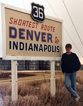
Picture
1992
(I should note that there were two copies of this sign, one posted on each end of town.)  I thought it was interesting that, for the word "Denver", the sign maker used the same colors as the Broncos football team; and for "Indianapolis" the same colors as the Colts.  And, although black and white were used for the US 36 marker, the colors were the inverse of a standard US route marker.  I also thought it was interesting because it doesn't seem like there would be an abundance of commerce between those two cities.  But even if there was, I still found it odd to think of US 36 as the route of choice between Denver and Indianapolis, given the fact that the two cities are also linked by I-70.
Get your very own map showing all current and historic US routes!

I passed through Norton again about a decade later.  By then the signs had been replaced, but the verbiage remained the same:
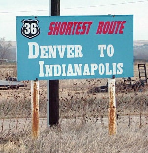
Picture
2001
Allan Ferguson (author of a book about Route 36) informs me that the Kansas-based US 36 Highway Association and the Norton Chamber of Commerce were the organizations mainly responsible for those signs.  But it seems odd that they didn't erect signs along US 36 all across the state (rather than just in Norton).  

What prompted these signs?  Multiple east-west routes cross the state of Kansas.  Prior to the Interstates, each of these highways were shown on maps with identical line weights and colors.  A driver planning a trip would get the impression that they had several options which were equally-viable.  For example, here is an excerpt from a 1959 atlas, showing the area between Denver and Kansas City:
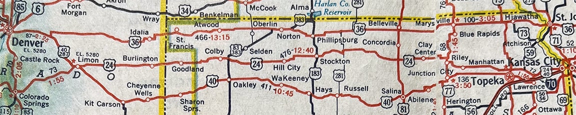
Picture
c. 1959, Gousha
Norton is shown in the upper center.  Someone heading east from Denver would likely choose either US 24 across Kansas (if they wanted to pass through Kansas City) or else US 36 (if they preferred to bypass Kansas City).  And if their destination happened to be Indianapolis, they would almost certainly choose US 36, since it is the most direct route.

But when the Interstates were built, they were shown on maps with a thicker line weight and a more prominent color.  For example, this 1986 map gives the impression that I-70 is the lone "main" route across Kansas, while the other routes are of only secondary importance:
Picture
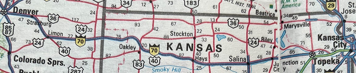
c. 1986, Rand McNally
Cartographers are not to be faulted for this.  Interstates represented a whole new class of highways: faster speed limits, no stop lights or at-grade intersections, multiple lanes to make passing easier, etc.  Due to these factors and more, instead of looking for the most direct route, travelers began to think in terms of "Can I get to my destination using Interstates?"  As a result, thousands of towns throughout the U.S. that had been left out of the Interstate highway network began to find that they were losing traffic and commerce to towns that were located along the Interstate corridors.  

For many travelers, US 36 no longer looked like the best option between Denver and Indianapolis, not when they could use I-70 instead.  So US 36 across northern Kansas became one of those corridors that saw reduced traffic.  So some organizations in Kansas decided to try and lure travelers back to US 36 by putting up the signs shown above.  These signs pointed out that, despite the existence of I-70, the shortest distance between Denver and Indianapolis was still US 36.  Is that actually true?  Let's see, according to Google Maps...
  • Denver to Indianapolis via I-70 is about 1087 miles.
  • Denver to Indianapolis via US 36 is only about 1041 miles, or 46 miles less than I-70.

​OK, but again, most people are more concerned with time, not distance.  So which route is faster?
  • According to Google Maps, Denver to Indianapolis via I-70 takes about 16 hours.
  • Denver to Indianapolis via US 36 takes about 17:30 hours.
  • So using I-70 would save about an hour and a half compared to using US 36.
  • Therefore, although the signs were technically correct, the verbiage may not have motivated many travelers to use US 36.
On my most recent trip through Norton (2022), I saw that the signs had changed significantly (images on Google Street View indicate this happened sometime after 2018):
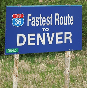
Picture
2022
For one thing, although the shape of the shield on the highway marker is (approximately) correct for a US highway, it uses the colors of an Interstate highway shield.  That is actually a common mistake among graphic designers, who may not know (or care) about the difference between a US highway and an Interstate highway.  However, in this particular case I wonder if it may have been intentional (more on that below).  Another notable difference is that the emphasis of the message has shifted from "shortest" to "fastest" (the sign for traffic heading the opposite direction says "Fastest Route to Indianapolis").
So what prompted this shift in focus?  It appears to have been conceded that most drivers care more about "fast" (time) than "short" (distance).  And secondly, these new signs do emphasize some information which is indeed relevant to drivers in the Norton area, and which may prompt them to stay on US 36 (as opposed to I-70).  

Norton is essentially the same distance from Denver as it is from Kansas City, so a significant percentage of drivers approaching Norton from the east on US 36 are ultimately destined for the Denver area.  These drivers may be tempted to take K-383 southwest out of Norton (a diagonal highway that leads to an I-70 connection at Colby).  But if they did that, would they be on the fastest route to Denver?  Let's see...
  • Norton to Denver via K-383 and I-70 is about 4:45 and 309 miles.
  • Norton to Denver via US 36 is more like 4:30 and only 285 miles.
  • So staying on US 36 does save about 15 minutes (and also about 25 miles), compared to I-70.
  • For those heading to Denver, US 36 truly is a quicker route than dropping down to the Interstate.

Regardless whether they choose US 36 or I-70, westbound drivers will pass through Norton either way.  That is why I wondered if these signs might have been encouraged by town(s) further west on US 36.  And sure enough, Allan informs me that someone in Norcatur was one of the main drivers on the latest version of these signs.

Now, regarding eastbound traffic...
  • Norton to Indianapolis going through Manhattan and then via I-70 is 12:30 and 808 miles.
  • Norton to Indianapolis via US 36 is 12:17 and 777 miles.
  • So staying on US 36 saves about 13 minutes and 31 miles compared to I-70.
But again, we have to keep in mind that these figures are only for people who are already in Norton.  As I pointed out above, drivers wanting to go all the way from Denver to Indianapolis (or vice versa) would reach their destination quicker by using I-70.

Now, back to the US 36 shield that is colorized to look like an Interstate shield: was it just an oversight, or was it intentional?  Possibly the thinking went something like this: "If we make the US 36 shield to look basically the same as an I-70 shield, then maybe drivers will think there's not much difference between the two roads.  And if so, then maybe that will encourage them to just stay on US 36, since it's shorter anyway."  Of course, it wouldn't take long on US 36 for drivers to notice that the old two-lane highway actually has quite a few differences compared to a four-lane, limited-access Interstate.  But not all of the differences are negative.  For example, there is very little traffic on US 36, and the scenery can be interesting.  So maybe some drivers would actually prefer US 36 over I-70.  And maybe they would choose US 36 again, next time they drive between Denver and Norton.
2 Comments
Robert B
12/4/2022 01:18:45 pm

There's a billboard on I-35 southbound in Missouri, just before the US 36 intersection, suggesting the US route as a better alternative for visitors heading across Kansas. I'll have to take a better look at it next time I go that way!

Reply
Steve Pederson
10/4/2024 07:56:03 pm

While mapgazing a number of years ago I noticed just how straight US 36 is across CO and KS, but still haven't had an opportunity to use it.

However, I'll take a lightly travelled 2 lane road is a big plus over a busy truck-laden interstate!

Reply

Your comment will be posted after it is approved.


Leave a Reply.

    RSS Feed

    Author

    This guy.

    Categories

    All
    Alabama
    Arizona
    Boston
    California
    Colorado
    Denver
    Florida
    Geo-center
    Geography
    Historic
    Idaho
    Illinois
    Indiana
    Kansas
    Kentucky
    Maryland
    Massachusetts
    Michigan
    Midpoint
    Mileage
    Minnesota
    Missouri
    Nebraska
    New Hampshire
    New Jersey
    New Mexico
    Newport
    New York
    North Carolina
    North Dakota
    Numbering
    Oddity
    Ohio
    Oklahoma
    Oregon
    Pennsylvania
    Proposed
    Renumbering
    Signage
    South Carolina
    South Dakota
    Tennessee
    Texas
    Updates
    US 101
    US 127
    US 13
    US 136
    US 150
    US 154
    US 16
    US 160
    US 163
    US 164
    US 169
    US 177
    US 180
    US 183
    US 190
    US 191
    US 20
    US 210
    US 212
    US 218
    US 220
    US 23
    US 231
    US 24
    US 241
    US 25
    US 259
    US 26
    US 266
    US 27
    US 270
    US 271
    US 277
    US 281
    US 283
    US 285
    US 287
    US 3
    US 31
    US 311
    US 321
    US 331
    US 34
    US 36
    US 360
    US 371
    US 377
    US 383
    US 385
    US 40
    US 400
    US 411
    US 431
    US 450
    US 46
    US 48
    US 491
    US 50
    US 530
    US 55
    US 59
    US 6
    US 60
    US 61
    US 62
    US 63
    US 65
    US 66
    US 666
    US 67
    US 730
    US 74
    US 77
    US 80
    US 81
    US 83
    US 84
    US 85
    US 87
    US 89
    US 93
    US 94
    US 96
    US 99
    Utah
    Virginia
    Washington
    Watersheds
    West Virginia
    Wyoming

    Archives

    April 2025
    July 2024
    August 2023
    May 2023
    March 2023
    February 2023
    January 2023
    August 2022
    March 2022
    February 2022
    January 2022
    August 2021
    July 2021
    June 2021
    April 2021
    February 2021
    January 2021
    August 2020
    July 2020
    May 2020
    April 2020
    March 2020
    February 2020
    January 2020
    December 2019
    October 2019
    September 2019
    August 2019
    May 2019
    January 2019
    November 2018
    June 2018
    April 2018
    March 2018
    November 2017
    September 2017
    August 2017
    June 2017
    March 2017
    February 2017
    January 2017
    December 2016

Copyright © 1998-2025
Picture