US Ends .com
  • Home
  • Store
    • US highway book
    • US highway map
    • Florida US highway map
  • Endpoints
    • US 1 - US 9 >
      • 1 >
        • 201
        • 301
        • 401 [i]
        • 401 [ii]
        • 401
        • 501
        • 601
        • 701
      • 2w >
        • 102
      • 2e >
        • 202
        • 302
      • 3
      • 4 >
        • 104
      • 5
      • 6 >
        • 106
        • 206
      • 7
      • 8
      • 9 >
        • 109*
        • 209
        • 309
    • US 10 - US 19 >
      • 10 >
        • 110
        • 210
        • 310
        • 410
      • 11 >
        • 111
        • 211
        • 311
        • 411 [i]
        • 411 [ii]
        • 411
        • 511*
        • 611
        • 711*
      • 12 >
        • 112
        • 212
        • 312
      • 13 >
        • 113
        • 213
      • 14
      • 15
      • 16 >
        • 116
        • 216
      • 17 >
        • 17-1
        • 117 [i]
        • 117
        • 217
      • 18 >
        • 118
        • 218
      • 19 >
        • 119
        • 219
        • 319
    • US 20 - US 29 >
      • 20e >
        • 120
        • 220
        • 320
        • 420
      • 20w
      • 21 >
        • 121 [i]
        • 121
        • 221
        • 321
        • 421
        • 521
      • 22 >
        • 122 [i]
        • 122 [ii]
        • 222
        • 322
        • 422e
        • 422w
        • 522
        • 622*
      • 23 >
        • 123 [i]
        • 123
        • 223
      • 24 >
        • 124
        • 224
      • 25
      • 26 >
        • 126
      • 27 >
        • 127
        • 227
      • 28
      • 29 >
        • 129
    • US 30 - US 39 >
      • 30 >
        • 130
        • 230
        • 330
        • 430
        • 530
        • 630*
        • 730
        • 830
      • 31 >
        • 131
        • 231
        • 331 [i]
        • 331
        • 431
      • 32
      • 33
      • 34
      • 35
      • 36 >
        • 136
      • 38 >
        • 138
    • US 40 - US 49 >
      • 40 >
        • 140
        • 240
        • 340
      • 41 >
        • 141
        • 241 [i]
        • 241 [ii]
        • 341
        • 441 >
          • 441n
          • 441s
        • 541
        • 641
      • 42
      • 43
      • 44
      • 45
      • 46
      • 48 [i]
      • 48 [ii]
      • 48
      • 49
    • US 50 - US 59 >
      • 50 >
        • 150
        • 250
        • 350
        • 450
        • 550
        • 650
      • 51 - 55 >
        • 51 >
          • 151
        • 52 >
          • 152
        • 53
        • 54 >
          • 154
        • 55
      • 56 >
        • 156
      • 57
      • 58 >
        • 158
        • 258
      • 59 >
        • 159
        • 259
    • US 60 - US 69 >
      • 60 >
        • 160
        • 260
        • 360
        • 460
      • 61 - 65 >
        • 61 >
          • 161
        • 62
        • 63 >
          • 163 [i]
        • 64 >
          • 164 [i]
          • 164 [ii]
          • 264
        • 65 >
          • 165
      • 66 >
        • 166
        • 266
        • 366 [i]
        • 366 [ii]
        • 466 [i]*
        • 466 [ii]
        • 566
        • 666
      • 67 >
        • 167
      • 68 >
        • 168
      • 69 >
        • 169
    • US 70 - US 79 >
      • 70 >
        • 170
        • 270 [i]*
        • 270
        • 370
        • 470
      • 71 >
        • 171
        • 271
        • 371 [i]
        • 371 [ii]
        • 371
      • 72 - 76 >
        • 72
        • 73
        • 74
        • 75 >
          • 175
          • 275
        • 76 >
          • 176
          • 276
      • 77 >
        • 177
        • 277
        • 377
      • 78 >
        • 178
        • 278
        • 378
      • 79
    • US 80 - US 89 >
      • 80 - 84 >
        • 80 >
          • 180 [i]
          • 180
          • 280
          • 380
        • 81 >
          • 181
          • 281
        • 82
        • 83 >
          • 183
          • 283
          • 383
        • 84
      • 85 - 89 >
        • 85 >
          • 185
          • 285 [i]
          • 285
          • 385 [i]
          • 385
          • 485
        • 87 >
          • 187
          • 287n
          • 287s
        • 89n
        • 89s >
          • 189 [i]
          • 189
    • US 90 - US 99 >
      • 90 - 94 >
        • 90 >
          • 190
          • 290
        • 91 >
          • 191 >
            • 191n
            • 191s
          • 491
        • 92 >
          • 192
        • 93
        • 94
      • 95 -98 >
        • 95 >
          • 195
          • 295
          • 395
        • 96 [i]
        • 96
        • 97 >
          • 197
        • 98
      • 99 >
        • 199
        • 299
        • 399
    • Anomalies >
      • 101
      • 163
      • 400
      • 412
      • 425
  • Places
    • A-L >
      • A >
        • Aberdeen
        • Albuquerque
        • Amarillo
        • Apalachicola
        • Astoria
        • Atlantic
      • B >
        • Baltimore
        • Baton Rouge
        • Bay Area
        • Bishop
        • Boone
        • Brady
        • Bristol
        • Brownsville
        • Brunswick
      • C >
        • Charleston
        • Chattanooga
        • Chicago
        • Cincinnati
        • Cleveland
        • Cody
        • Corpus
        • Cortez
        • Council Bluffs
        • Covington
        • Crescent
        • Cumberland Gap
      • D-E >
        • Dallas
        • Des Moines
        • Detroit
        • Dothan
        • Douglas
        • El Paso
        • Erie
        • Eugene
      • F >
        • Farmington
        • Flagstaff
        • Florence
        • Fox Valley
        • Franklin
      • G >
        • Gallup
        • Georgetown
        • Grand Junction
        • Grand Portage
        • Grayling
        • Great Falls
        • Greeley
      • H-I >
        • Hardeeville
        • Harrisburg
        • Holbrook
        • Idaho Falls
        • Int'l Falls
      • J-K >
        • Jacksonville
        • Joplin
        • Junction
        • Kansas City
        • Keokuk
        • Key West
        • Kingman
      • L >
        • Laredo
        • Lewiston
        • Long Beach
        • Los Angeles
        • Louisville
        • Lubbock
    • M-R >
      • M >
        • Mackinaw
        • Madison
        • Maryhill
        • Maysville
        • Miami
        • Midway
        • Miles City
        • Milford
        • Milwaukee
        • Minneapolis
        • Mobile 31
        • Mobile 31-43-45
        • Montgomery
        • Monticello
        • Mount Vernon
      • N-O >
        • Nags Head
        • Naples
        • Natchez
        • New Castle
        • New Orleans
        • Niagara
        • Norlina
        • Ocean City
        • Oklahoma City
      • P >
        • Pee Dee
        • Pembina
        • Pensacola
        • Petersburg
        • Philadelphia
        • Piegan
        • Pineville
        • Port Arthur
        • Portsmouth
      • Q-R >
        • Quad Cities
        • Rapid City
        • Raton
        • Reading
        • Richmond
        • Rockingham
        • Rouses Point
    • S-Z >
      • S >
        • San Antonio
        • San Antonio NM
        • San Diego
        • Santa Fe
        • Savannah
        • Sioux
        • Springer
        • Springfield
        • St. Ignace
        • St. John
        • St. Paul
        • St. Pete
      • T-U-V >
        • Tallahassee
        • Tampa
        • Toledo
        • Trinidad
        • Tuba City
        • Ucolo
        • VA Beach
      • W >
        • Walterboro
        • Waverly
        • West Memphis
        • Wilmington
        • Wilson
        • Wrightsville
      • Y >
        • Yellowstone E
        • Yellowstone N
        • Yellowstone NE
        • Yellowstone S
        • Yellowstone W
  • Highways
    • Map of all endpoints
    • Sources
    • History
    • 1926 almost-routes
    • Intra-state routes
    • Numbering
    • Colors
    • Gaps
    • Blog
  • Bonus
    • Colorado >
      • Lowest point
      • Antipodes
      • Toponymy >
        • Roots
      • Colloquialisms
      • Populations
      • Denvers
    • Washington Meridian
    • Watersheds >
      • Headwaters Hill
      • Three Waters Mtn.
      • Parting of the Waters
    • Geo-centers >
      • 48 states
      • 50 states
      • North America
    • State corners >
      • AZ-CO-NM-UT
      • CO-UT-WY
      • CO-NE-WY
      • CO northeast
      • CO-KS-NE
      • CO-KS-OK
      • CO-NM-OK
      • NM-OK-TX
      • NM southeast
      • TX northwest
  • Connect
    • Author/history
    • Rationale
    • Contact
    • Contributors
    • Submissions

US Highways Blog

Misleading highway signage in Denver

8/7/2021

4 Comments

 
The other day I was driving north on C-470, and I wanted to go east on the 6th Avenue Freeway towards downtown Denver.  That movement is shown on the map below:
I rarely drive that direction along C-470, but I have lived in Denver for a long time, and I'm pretty confident about knowing my way around.  So as I approached, I was quite certain that I would need to follow eastbound I-70, and that the exit for eastbound US 6 would come up shortly after that. 

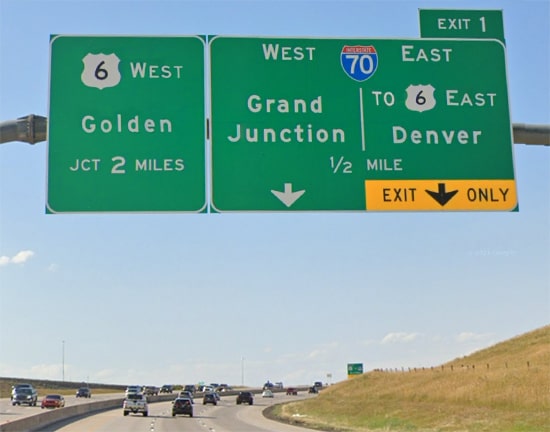
​But then I saw this: the first sign that references US 6 on northbound C-470:
Picture
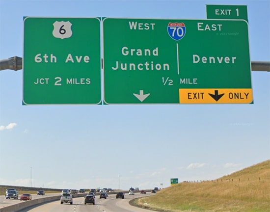
All imagery from Google Maps Street View
The panel on the left has a US 6 shield with no directional modifier.  In other words, it doesn't specify "WEST US 6", so the implication is that both directions of US 6 (east and west) will need to get in the left lane.  The panel on the right does not say that eastbound US 6 traffic should follow I-70.  So at this point I started doubting my plan and questioning my memory.  "If I follow eastbound I-70, maybe there is something that would prevent me from being able to access eastbound US 6..?"

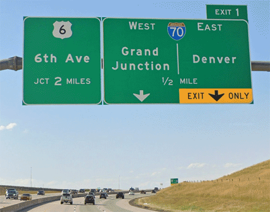
​The next sign after that references only westbound US 6; it does not provide any info for drivers who want eastbound US 6:
Picture
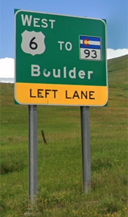
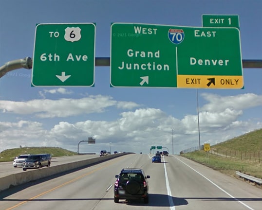
The sign at the exit gore repeats the earlier information: all US 6 traffic should be in the left lane.  Again, there is no mention of US 6 on the right-hand panel:
Picture
So I thought, "Well, I guess my memory is wrong, I better follow the signs."  But shortly after doing so, I quickly realized that I hadn't been wrong: I should have followed eastbound I-70 after all.  As it was, I reached US 6, turned east, and soon passed through the US 6 / I-70 interchange.  But if I had used I-70, I would have been at that same interchange a couple minutes earlier, and I would have stayed entirely on freeways.  Following the signs causes eastbound US 6 travelers to pass through a couple traffic signals, lose a couple minutes, and go about a mile more than necessary.  

​Even if I had done it correctly and taken the exit for I-70 traffic, the next sign still does not provide any info for drivers wanting to head east on the US 6 freeway:
Picture
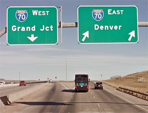
Now let's think about this for a minute.  Let's take all drivers who are both a.) heading north on C-470 and b.) exiting to any direction on US 6.  Out of all drivers meeting those criteria, what percentage do you think are heading east on US 6 towards downtown?  I don't have the data, but I bet it's the vast majority.  I would guess it's something like this:
  • Drivers staying on C-470 (purple line) and then turning east on US 6 (red line): 5%
  • Drivers staying on C-470 (purple line) and then turning west on US 6 (blue line): 20%
  • Drivers using eastbound I-70 to access eastbound US 6 (green line): 75%
(​If you have access to actual traffic data that can make my numbers more accurate, please contact me via the form below.  But I bet that's pretty close.)

The way it stands now, signage directs all US 6 traffic to stay on C-470 (via the route shown in purple above), even though that route accounts for only 25% of US 6 traffic.  The remaining 75% of US 6 traffic should follow route shown in green above, yet currently there is no signage directing US 6 drivers along that route.

I realize it is sometimes desirable to reduce information overload by keeping highway signage simple.  But sometimes oversimplification can be misleading, and the current signage along this segment of C-470 is one such example.  With just a few minor changes, these signs could be made much more informative for the majority of US 6 traffic movements.  Let's take another look at the first photo on this page:
Picture
Again, the left panel is misleading because it implies that all US 6 traffic should stay to the left.  And it is misleading for another reason: instead of a control city, the left panel references a roadname (6th Ave).  Since 6th Ave runs both east and west from the junction with C-470, drivers cannot glean any further clarification from that.  So it would be a huge improvement to change the left panel to something like this:
Picture
That provides clarification that only westbound US 6 traffic should be in the left lane.  It provides further clarification by using the city of Golden as a control point.  But what about all the drivers who want to follow eastbound US 6?  After all, that is the most common traffic movement here, so it should definitely be signposted.  That is why some additional changes were made to the right-hand panel above.  The following image makes it easier to compare the current sign with the proposed sign:
Picture
If those changes were made to the two overhead sign bridges on northbound C-470, then 95% of all traffic exiting to US 6 would be well-served.  One might ask, "What about the 5% of drivers who need to use the one-mile segment of US 6 between C-470 and I-70?"  The control point of "Golden" would be helpful for them, but other than that, my thought is that no additional signage is needed for those drivers.  If a choice needs to be made between serving 25% of the traffic vs. 95% of the traffic... well, frankly that's a no-brainer.
4 Comments
Doug Moore
8/9/2021 02:27:11 am

The narrative implies that you were forced to head west on US 6, but on more careful reading, it appears that you should have been able to turn right on US 6 at the intersection. So your complaint seems to be that you knew a shortcut, and the overhead sign led you to not exploit it. While it's true that the signage directs you to the nearest point of US 6, perhaps no sign would be better, or one indicating that Johnson Street was ahead for those not taking the exit. But, honestly, the sign seems fine to me.

Reply
US Ends .com link
8/9/2021 06:33:20 am

Correct, drivers who follow the US 6 signs are able to turn east on US 6 (not just west). I have edited the text a bit in an attempt to clarify that point.

Reply
Robert B
9/19/2021 10:32:12 am

I seldom see US routes given much attention, especially since the assumption is that The Expressway is the only road that really matters. I'm not even sure some states even give their signs a second look, since everyone uses GPS now (to their own detriment). I'm looking at you, Indiana. :(

Reply
Stephen V Sassi
12/25/2022 01:22:51 pm

On a trip across Colorado more than 15 years ago on I-70 I noticed some very bizarre postings for US 6. Approaching the Denver area on the 6th Ave Freeway there is no sign at all for east 6 at the I-25 interchange.
I've read since then that US routes in Colorado are not (or rarely) posted when multiplexed with Interstate highways. For instance, US 85 and 87 are almost non-existent. Not to pick on Colorado as my own state, New York, has a habit of posting US highways as state highways. US 202 for about 40% of its length is posted as NY 202.
The problem is that people talk about Route X without regard to whether Route X is US, state, county, or township.
For my part I try to say, US or state route when possible.

Reply

Your comment will be posted after it is approved.


Leave a Reply.

    RSS Feed

    Author

    This guy.

    Categories

    All
    Alabama
    Arizona
    Boston
    California
    Colorado
    Denver
    Florida
    Geo-center
    Geography
    Historic
    Idaho
    Illinois
    Indiana
    Kansas
    Kentucky
    Maryland
    Massachusetts
    Michigan
    Midpoint
    Mileage
    Minnesota
    Missouri
    Nebraska
    New Hampshire
    New Jersey
    New Mexico
    Newport
    New York
    North Carolina
    North Dakota
    Numbering
    Oddity
    Ohio
    Oklahoma
    Oregon
    Pennsylvania
    Proposed
    Renumbering
    Signage
    South Carolina
    South Dakota
    Tennessee
    Texas
    Updates
    US 101
    US 127
    US 13
    US 136
    US 150
    US 154
    US 16
    US 160
    US 163
    US 164
    US 169
    US 177
    US 180
    US 183
    US 190
    US 191
    US 20
    US 210
    US 212
    US 218
    US 220
    US 23
    US 231
    US 24
    US 241
    US 25
    US 259
    US 26
    US 266
    US 27
    US 270
    US 271
    US 277
    US 281
    US 283
    US 285
    US 287
    US 3
    US 31
    US 311
    US 321
    US 331
    US 34
    US 36
    US 360
    US 371
    US 377
    US 383
    US 385
    US 40
    US 400
    US 411
    US 431
    US 450
    US 46
    US 48
    US 491
    US 50
    US 530
    US 55
    US 59
    US 6
    US 60
    US 61
    US 62
    US 63
    US 65
    US 66
    US 666
    US 67
    US 730
    US 74
    US 77
    US 80
    US 81
    US 83
    US 84
    US 85
    US 87
    US 89
    US 93
    US 94
    US 96
    US 99
    Utah
    Virginia
    Washington
    Watersheds
    West Virginia
    Wyoming

    Archives

    April 2025
    July 2024
    August 2023
    May 2023
    March 2023
    February 2023
    January 2023
    August 2022
    March 2022
    February 2022
    January 2022
    August 2021
    July 2021
    June 2021
    April 2021
    February 2021
    January 2021
    August 2020
    July 2020
    May 2020
    April 2020
    March 2020
    February 2020
    January 2020
    December 2019
    October 2019
    September 2019
    August 2019
    May 2019
    January 2019
    November 2018
    June 2018
    April 2018
    March 2018
    November 2017
    September 2017
    August 2017
    June 2017
    March 2017
    February 2017
    January 2017
    December 2016

Copyright © 1998-2025
Picture