|
(Most recently updated 4/5/2022)
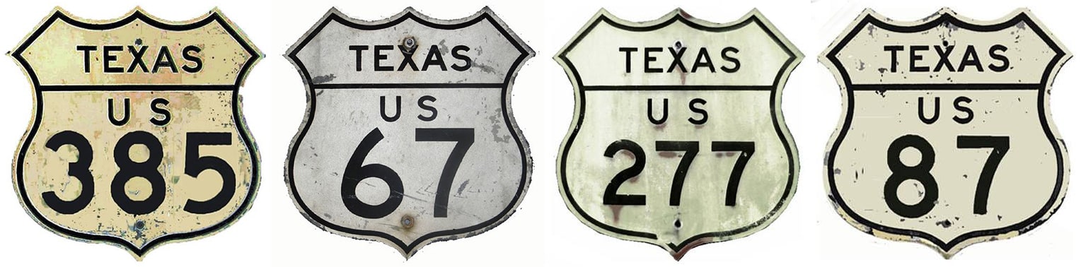
Shield images courtesy of Michael Summa
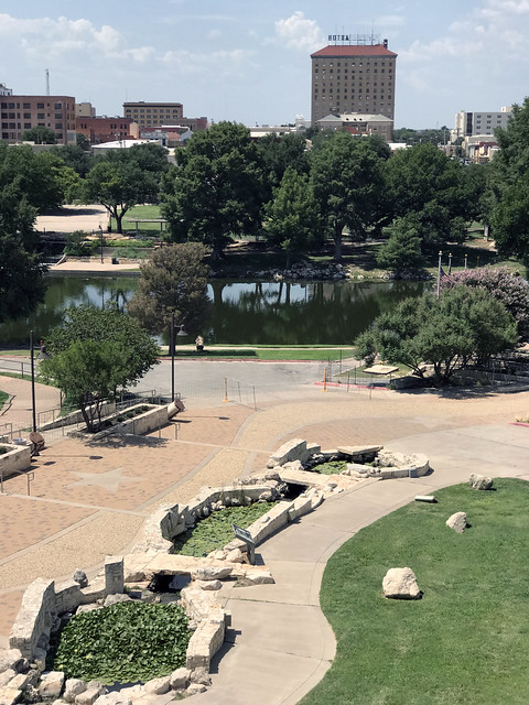
One of San Angelo's marketing slogans is "The Oasis of West Texas". This is not hyperbole; most approaches to the city are somewhat stark, so in contrast upon arrival in Angelo, one may well be pleasantly surprised at all of the rivers, reservoirs, trees and other vegetation:
One of the city's other monikers is "The Pearl of the Conchos", which has a double meaning, referring to the freshwater Concho pearls that were historically harvested from area waterways. The three branches of the Concho River all converge in San Angelo; that was illustrated on this other slogan from days gone by:
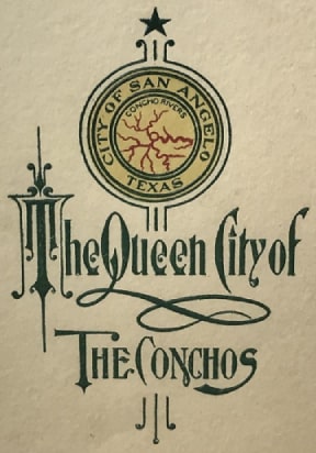
On display at ASU's Mayer Museum, Jun. 2021
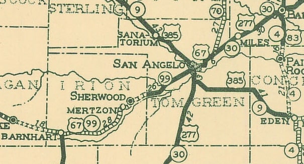
When the US highway system was inaugurated in late 1926, the only US route to initially serve San Angelo was US 385 (that is, the original US 385, not the current US 385). The new designation was added to Texas State Highway 9:
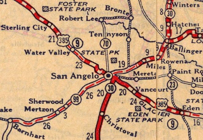
c. 1927, Rand McNally
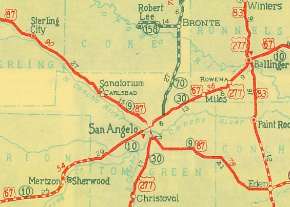
It was not long before US 385 got some company: by 1930 the US 67 designation was extended through San Angelo, and that same year the US 277 designation was established, also running through Angelo...
c. 1933, TXDoT
...although it should be noted that initially US 277 did not follow its present routing to Abilene (via Bronte). Rather, it was concurrent with US 67 all the way to Ballinger, and then overlapped with US 83 up to Abilene (US 277 traffic was not redirected through Bronte until 1948):

c. 1934, Rand McNally
In 1935, the US 87 designation was given a major extension south and east from Wyoming, and it subsumed US 385 in its entirety:
c. 1936, TXDoT
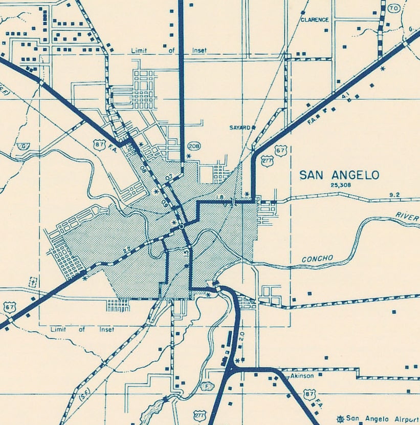
The following 1936 map illustrates exactly which city streets highway traffic was directed to use through San Angelo at the time. US 87 (and formerly US 385) followed Chadbourne Street through the downtown area (including the short jog along 5th Street, which is still there today). The junction with US 67 and US 277 was at Harris Avenue:
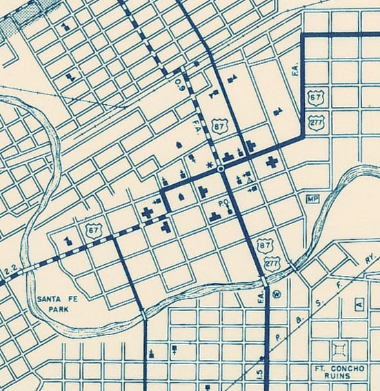
c. 1936, TXDoT
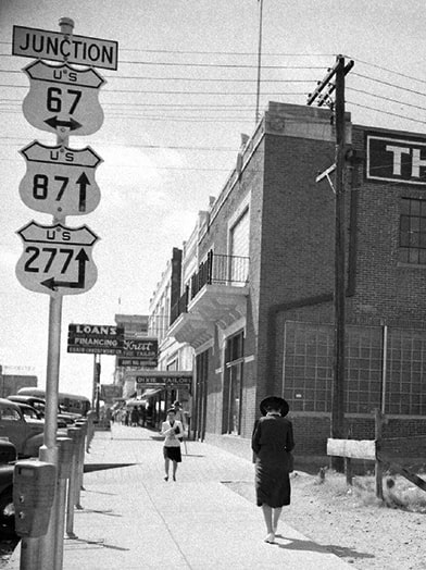
Coincidentally, the intersection of Chadbourne and Harris also serves as the point of origin for San Angelo's address system. From that historic highway junction, southbound US 277 was twinned with US 385-87 along Chadbourne. Northbound US 277 had an overlap with northeastbound US 67 via Harris, then north along Main Street, resuming east on Pulliam Street. Southwestbound US 67 turned south off Harris via Randolph Street, then west again along Beauregard Avenue. (Why the jog, you might ask? After all, today Main continues south of Harris and directly connects with Beauregard. However, that was not the case on the map above; Main was not extended until the 1940s or '50s.) This 1945 photo was taken looking south on Chadbourne approaching Harris:
c. 1945, Frank Scherschel, LIFE Collections (detail)

The following map is also from 1936, but it shows a wider area and illustrates how highway traffic was directed beyond the city center. After heading east on Pulliam, northbound US 67-277 turned north on Bell Street, which then curved to become Ballinger Highway (today known as Old Ballinger Hwy). In the northeast corner is visible TX hwy. 70, which became US 277 in 1948:
c. 1936, TXDoT
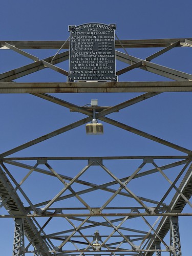
Southbound US 67 followed Beauregard to the curve where it becomes Sherwood Way. Southbound US 385-87-277 used Chadbourne to Avenue "K", where traffic was directed to cross the South Concho River via the Lone Wolf Bridge:

That bridge is no longer open to motor vehicles, but it is still preserved for pedestrians and recreationalists:


After crossing the Lone Wolf Bridge, US 385-87-277 traffic went south on Christoval Road. After 1.5 miles, the two routes diverged. US 277 continued south on Christoval, but US 385-87 traffic was directed east on what was known at the time as Eola Road (but which later became Old Eola Rd, and has since become an extension of Chadbourne, as is further discussed below). After another mile US 385-87 went southeast on what is now Farm-to-Market Road 1223. In three miles there is a slight interruption in the historic alignment thanks to modern US 87, but once beyond there FM 1223 resumes its southeastward bearing. Then in about one more mile, US 385-87 veered due east on what is now Cottonseed Road. Today that road dead-ends at Debus Road, but historically US 385-87 continued east, joining the current alignment of US 87 just east of Debus.
If the preceding text description is unclear, the map below should be helpful. Original US route alignments are shown in black; vacated alignments are red; and intermediate alignments are shown in purple:
Briefly skipping ahead just a bit: in 1945, Chadbourne was extended south of Avenue "N" via new bridges across Red Arroyo and the South Concho. This new road then curved east and aligned with the aforementioned Eola Road at its junction with Christoval. US 87-277 was rerouted to follow this extension of Chadbourne, so at that time Avenue "K" and the Lone Wolf Bridge no longer carried US highway traffic (Incidentally, today's Avenue "L" bridge eventually replaced the functionality of the Lone Wolf Bridge, but that was not built until about 1960).
Now we turn our attention back to northbound US 385-87. Heading north from downtown on Chadbourne, originally TX hwy. 208 began to the east on 14th, as shown in this photo: 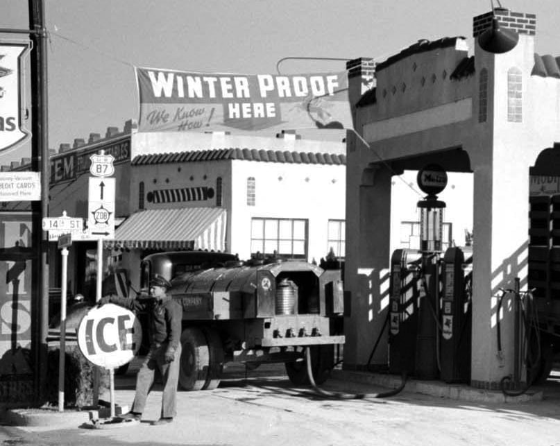
detail (date and attribution unknown, but post-1935, and reportedly TXDoT used these "star" state highway markers only until about 1945)
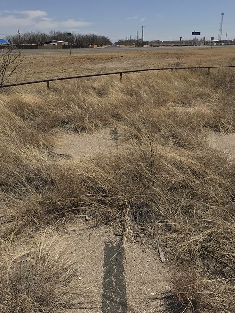
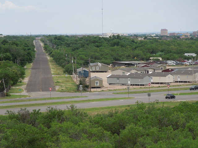
By the 1950s TX 208 had been changed to follow 19th Street instead of 14th. Further north, originally US 385-87 turned west on 29th Street, then northwest on Lake Drive. Today Lake Dr. ends at its junction with modern US 87 (Bryant Boulevard), but that is only because the O.C. Fisher Dam lies just west of there. Before the dam was built, Lake Dr. extended further west. In fact, just to the west of Bryant some of Lake's old pavement still exists, and in a couple places the old centerline is still apparent:
In the distance the still-extant segment of Lake is visible, heading towards its junction with 29th and Chadbourne. The photo below was looking the same direction as the one above (southeast along Lake Dr) except it was taken from the top of the dam crest:
In the right background is part of downtown San Angelo; in the foreground is Bryant (modern US 87). Before this dam was built, northwestbound US 385-87 continued directly behind the camera along essentially the same alignment all the way to modern US 87 in the community of Grape Creek. Construction on the "San Angelo Dam" began in 1947 (the dam and reservoir were renamed after Congressman O.C. Fisher in the 1970s). The dam crest was not built particularly high above the valley of the North Concho, nor does it impound a lot of water, but the dam is an impressive seven miles in length. Because of this, rerouting US 87 around the dam and future reservoir required nearly ten miles of new alignment. Chadbourne was extended further northwest, so instead of using 29th and Lake Drive, US 87 traffic was directed to stay on Chadbourne. From the point where Chadbourne ends at today's alignment of US 87, this newer highway continues northwest around the north edge of the dam, and then re-connects with its original alignment at Grape Creek.
So, after 1947, what happened to the original US 385-87? TXDoT vacated the highway, and the land through which the road passes became the property of the Army Corps of Engineers. Water began to be stored behind the dam in 1952, and according to historical data, the reservoir reached full capacity within five years (spring 1957 was the wettest season on record in that area, and there was a three-month period during which no water was released from the reservoir in order to minimize flooding downstream):
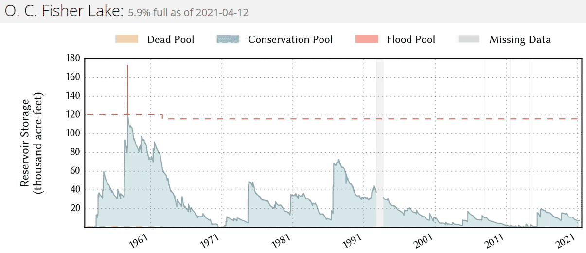
If I interpret maps correctly, that means the old highway would have been inundated from the dam to about four miles upstream. But it turns out that was the only time the reservoir has ever been at full capacity. In 1961 the water level began to drop quickly, and within ten years the reservoir was completely empty. Since then, the reservoir has risen above 60% capacity only once, and that was in the late 1980s. So, while much of the old highway has been underwater historically, that was true only for a brief time. In fact, the only part of the old highway that has been inundated for significant periods of time is the half-mile segment closest to the dam. This photo was taken from the top of the dam, looking the opposite direction from the photo above (northwest along the old highway):

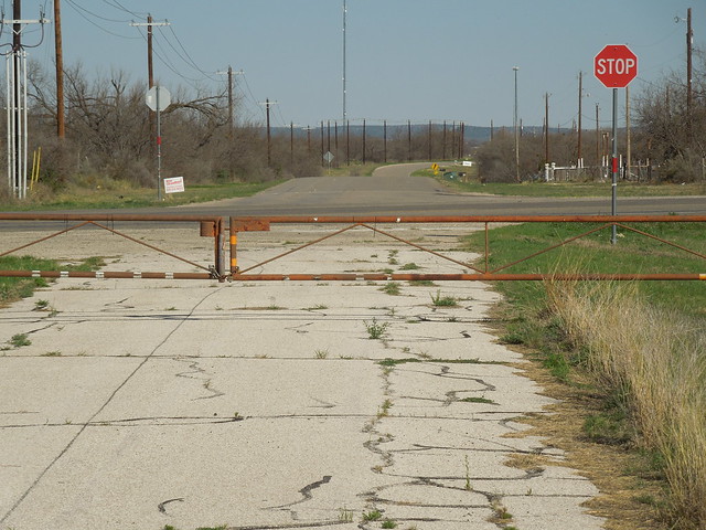
The segment in the foreground (closest to the dam) has been completely washed away; there is no longer any trace of the old roadbed. But starting a half-mile from the dam and heading upstream, the old road has been underwater only rarely (if ever), and it is still in quite good condition. For several years it was open to motor vehicles, providing access to the north shore of the reservoir. In fact, it was known as "North Shore Drive" for a time (although it is now more commonly referred to as "Old Sterling City Highway").
The Corps of Engineers has leased some of the property to San Angelo State Park and other sections to Angelo State University, and at some point one or more of those entities decided to close public access to the old highway. But in 2021 I obtained permission to access the area so that I could photograph historic US 385-87. We will start closest to the dam and work our way to the northwest. This photo shows the first intact segment heading upstream from the dam. Obviously it has not been open to traffic in years, but despite being practically overrun with cactus and other vegetation, the old centerline stripe is still visible: 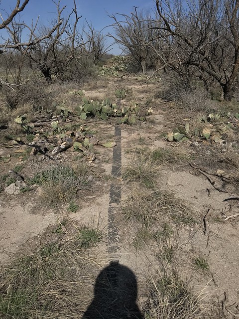
Not far behind the camera, the land drops in elevation to the east, and that is where all traces of the old highway have been completely washed away. To the left of this photo is what I believe was an old boat ramp sloping down from this road. The massive cluster of cactus visible straight ahead was growing on an earthen berm. In this next photo I was standing on that berm, looking down at the easternmost driveable portion of the old highway:

The section shown there is typical of what this entire segment of the old highway looks like: it still has a generally good surface, but there are lots of places where grasses / flowers / cacti are starting to take hold in soil that has collected in small cracks:

After about a mile, we come to a small bridge over an unnamed draw. The concrete barriers on both sides of the road have plaques noting 1936 as the date of construction:
The location of the former centerline stripe is still visible along the majority of the old highway. This next photo shows how grass is gradually working its way in from the edges. Some vegetation also grows in the center of the road, but this particular segment is still used frequently by ASU vehicles, which so far has prevented plant life from taking hold in the tire lanes:

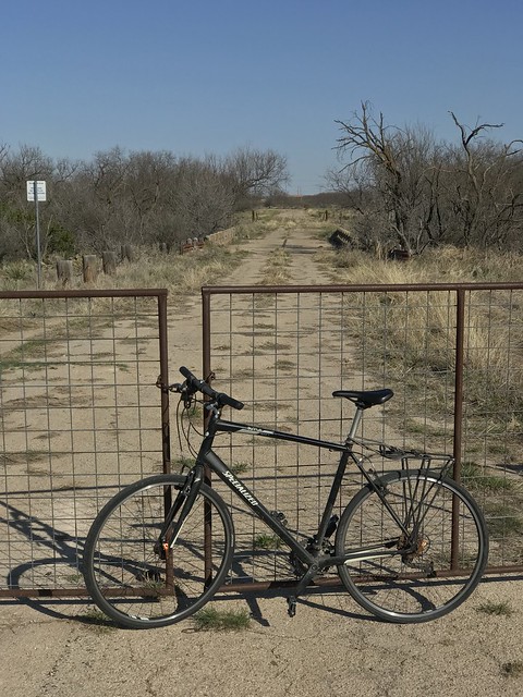
About 2.5 miles from the small bridge shown above we come to the first of several barricades along the western segment of the vacated highway (which is why I brought my bike to explore this part of the old road):
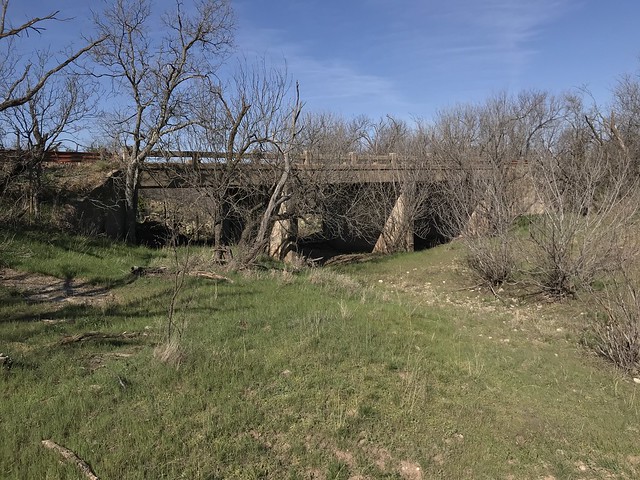
In the background another bridge is visible. This one is more substantial, spanning Bald Eagle Creek, and it is shown in more detail in the photos which follow:


In about a half-mile is another barricade...

...and another mile beyond that is yet another barricade near the end of this vacated segment of the old highway:
The stop sign is at FM 2288 in the community of Grape Creek, and straight ahead is a 1.3 mile long segment of Old Sterling City Hwy that is still maintained and open to traffic. At the end of that segment, traffic must now turn north to connect with modern US 87, but the original US 385-87 is still visible straight ahead, centerline stripe and all:

As mentioned previously, this original alignment of US 385-87 was bypassed in 1947, when the current alignment of US 87 east from Grape Creek was established. Initially that alignment fed traffic onto North Chadbourne in San Angelo, and that remained the case for about two decades. That was the highway situation illustrated on the cover of this 1955 plan:
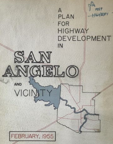
On display at ASU's Mayer Museum, Jun. 2021
In the late 1950s/early '60s construction began on part of San Angelo's loop freeway, specifically the segment around the southeast quadrant. This is designated Loop 306, but it also resulted in changes to the routings of all three US highways. In 1958 (and certainly by the time of the 1961 TXDoT map), US 67-277 had been moved off Old Ballinger Hwy. and Bell St. Instead traffic followed the modern alignment of US 67-277 to Loop 306 and then immediately exited to Pulliam St. and turned west to rejoin its old routing at Bell St. The photo below was taken from southwestbound US 67. Today the highway continues by curving to the left, but historically US 67-277 traffic was directed straight ahead on what is now Old Ballinger Hwy:
Then in the late 1960s segments of the current US 87 through San Angelo started to open to traffic. This is known as Bryant Boulevard, although in the downtown area traffic bifurcates into the one-way couplet of Abe Street and Koenigheim Street. At that time US 87's old routing along Chadbourne and Christoval was officially re-designated as Loop 378 (but reportedly signposted as Business 87 and Business 87-277). The former segment of US 87 between Christoval Rd. and Cottonseed Rd. was re-designated as an extension of FM 1223. In 1988 FM 1223 was extended west from Christoval and north along Chadbourne, replacing Loop 378 up to Avenue "L" (or FM 388). Loop 378 north of there was decommissioned, so the remainder of Chadbourne was given back to the City for maintenance. Since then only the segment of Christoval south of Chadbourne (FM 1233) is still designated Loop 378.
Now, back a few years to 1984: US 67 traffic was removed from its original routing through downtown, and instead changed to the current limited-access route, known as Houston Harte Expressway. Much of the original US 67 (Sherwood-Beauregard-Main) was designated Loop 545. At the time, this route ended on Main at Pulliam, and my interpretation is that Houston Harte may not have been completed to the northeast, so US 67 traffic must have exited at Main and resumed westward on Pulliam. In 1988 the segment of Loop 545 between Pulliam and US 87 (Abe-Koenigheim) was removed from the state highway system (in other words, Loop 545 remained only along Sherwood-Beauregard and no longer went through the downtown area). But then in 1996 that last segment of Loop 545 was decommissioned and instead redesignated as Business 67-H. (Officially this route actually continues north with US 87-277 to reconnect with mainline US 67, although that north-south segment is not acknowledged on signage, so as far as the driving public is concerned, Business 67-H functions as a spur). The photo below was taken looking southwest on Sherwood: 
At the same time, a second loop off US 67 was commissioned: Business 67-J begins in the northeast part of town by briefly following Loop 306 but immediately exiting to Pulliam and turning west. In other words, this business loop starts out by following what was described above as the route of mainline US 67-277 during the late 1950s/early '60s. However, at Main St. Business 67-J does not turn south towards downtown... instead it turns north and reconnects with mainline US 67:
This map illustrates both business loops:
So you can see that San Angelo has not just one, but two business routes off US 67... and astonishingly neither one goes through San Angelo's central business district! Instead of a single Business Loop 67 that does what every highway traveler would expect a business loop to do (i.e. follow the route of historic US 67 through the downtown area and reconnect with modern US 67 on both ends) -- San Angelo has two separate business loops that are not connected specifically because both of their routings avoid the central business district.
In April 2021 I contacted TXDOT's San Angelo district office to give them a chance to explain, but since I received no response, I will share my opinion without the benefit of their perspective. The fact that there is no longer an east-west state highway running through downtown San Angelo could be considered a bit unfortunate, but I don't have any serious concerns about that (after all, it is not unusual for city governments to request control of their main street from the state highway department). However, it is almost unprecedented -- not to mention very misleading and completely illogical -- to signpost two routes outside of the downtown area as business loops. It would be more appropriate to refer to Business 67-H by its former designation: Loop 545. That would be much more in line with what TXDOT has done in other cities all over the state, and there was no good reason to change it in 1996. As for Business 67-J, let me put it this way: if someone were to exit mainline US 67 because they had the expectation that following this so-called "business loop" would allow them to pass through the historic and/or cultural center of San Angelo, they would be sorely disappointed after driving Business 67-J. It is completely absurd to refer to that segment as a Business Loop. It should have been left as FM 380.
0 Comments
Your comment will be posted after it is approved.
Leave a Reply. |
AuthorCategories
All
Archives
July 2024
|


 RSS Feed
Copyright © 1998-2024
