US Ends .com
  • Home
  • Store
    • US highway map
    • Florida US highway map
  • Endpoints
    • US 1 - US 9 >
      • 1 >
        • 201
        • 301
        • 401 [i]
        • 401 [ii]
        • 401
        • 501
        • 601
        • 701
      • 2w >
        • 102
      • 2e >
        • 202
        • 302
      • 3
      • 4 >
        • 104
      • 5
      • 6 >
        • 106
        • 206
      • 7
      • 8
      • 9 >
        • 109*
        • 209
        • 309
    • US 10 - US 19 >
      • 10 >
        • 110
        • 210
        • 310
        • 410
      • 11 >
        • 111
        • 211
        • 311
        • 411 [i]
        • 411 [ii]
        • 411
        • 511*
        • 611
        • 711*
      • 12 >
        • 112
        • 212
        • 312
      • 13 >
        • 113
        • 213
      • 14
      • 15
      • 16 >
        • 116
        • 216
      • 17 >
        • 17-1
        • 117 [i]
        • 117
        • 217
      • 18 >
        • 118
        • 218
      • 19 >
        • 119
        • 219
        • 319
    • US 20 - US 29 >
      • 20e >
        • 120
        • 220
        • 320
        • 420
      • 20w
      • 21 >
        • 121 [i]
        • 121
        • 221
        • 321
        • 421
        • 521
      • 22 >
        • 122 [i]
        • 122 [ii]
        • 222
        • 322
        • 422e
        • 422w
        • 522
        • 622*
      • 23 >
        • 123 [i]
        • 123
        • 223
      • 24 >
        • 124
        • 224
      • 25
      • 26 >
        • 126
      • 27 >
        • 127
        • 227
      • 28
      • 29 >
        • 129
    • US 30 - US 39 >
      • 30 >
        • 130
        • 230
        • 330
        • 430
        • 530
        • 630*
        • 730
        • 830
      • 31 >
        • 131
        • 231
        • 331 [i]
        • 331
        • 431
      • 32
      • 33
      • 34
      • 35
      • 36 >
        • 136
      • 38 >
        • 138
    • US 40 - US 49 >
      • 40 >
        • 140
        • 240
        • 340
      • 41 >
        • 141
        • 241 [i]
        • 241 [ii]
        • 341
        • 441 >
          • 441n
          • 441s
        • 541
        • 641
      • 42
      • 43
      • 44
      • 45
      • 46
      • 48 [i]
      • 48 [ii]
      • 48
      • 49
    • US 50 - US 59 >
      • 50 >
        • 150
        • 250
        • 350
        • 450
        • 550
        • 650
      • 51 - 55 >
        • 51 >
          • 151
        • 52 >
          • 152
        • 53
        • 54 >
          • 154
        • 55
      • 56 >
        • 156
      • 57
      • 58 >
        • 158
        • 258
      • 59 >
        • 159
        • 259
    • US 60 - US 69 >
      • 60 >
        • 160
        • 260
        • 360
        • 460
      • 61 - 65 >
        • 61 >
          • 161
        • 62
        • 63 >
          • 163 [i]
        • 64 >
          • 164 [i]
          • 164 [ii]
          • 264
        • 65 >
          • 165
      • 66 >
        • 166
        • 266
        • 366 [i]
        • 366 [ii]
        • 466
        • 566
        • 666
      • 67 >
        • 167
      • 68 >
        • 168
      • 69 >
        • 169
    • US 70 - US 79 >
      • 70 >
        • 170
        • 270 [i]*
        • 270
        • 370
        • 470
      • 71 >
        • 171
        • 271
        • 371 [i]
        • 371
      • 72 - 76 >
        • 72
        • 73
        • 74
        • 75 >
          • 175
          • 275
        • 76 >
          • 176
          • 276
      • 77 >
        • 177
        • 277
        • 377
      • 78 >
        • 178
        • 278
        • 378
      • 79
    • US 80 - US 89 >
      • 80 - 84 >
        • 80 >
          • 180 [i]
          • 180
          • 280
          • 380
        • 81 >
          • 181
          • 281
        • 82
        • 83 >
          • 183
          • 283
          • 383
        • 84
      • 85 - 89 >
        • 85 >
          • 185
          • 285 [i]
          • 285
          • 385 [i]
          • 385
          • 485
        • 87 >
          • 187
          • 287n
          • 287s
        • 89n
        • 89s >
          • 189 [i]
          • 189
    • US 90 - US 99 >
      • 90 - 94 >
        • 90 >
          • 190
          • 290
        • 91 >
          • 191 >
            • 191n
            • 191s
          • 491
        • 92 >
          • 192
        • 93
        • 94
      • 95 -98 >
        • 95 >
          • 195
          • 295
          • 395
        • 96 [i]
        • 96
        • 97 >
          • 197
        • 98
      • 99 >
        • 199
        • 299
        • 399
    • Anomalies >
      • 101
      • 163
      • 400
      • 412
      • 425
  • Places
    • A-L >
      • A >
        • Aberdeen
        • Albuquerque
        • Amarillo
        • Apalachicola
        • Astoria
        • Atlantic
      • B >
        • Baltimore
        • Baton Rouge
        • Bay Area
        • Bishop
        • Boone
        • Brady
        • Bristol
        • Brownsville
        • Brunswick
      • C >
        • Charleston
        • Chattanooga
        • Chicago
        • Cincinnati
        • Cleveland
        • Cody
        • Corpus
        • Cortez
        • Council Bluffs
        • Covington
        • Crescent
        • Cumberland Gap
      • D-E >
        • Dallas
        • Des Moines
        • Detroit
        • Dothan
        • Douglas
        • El Paso
        • Eugene
        • Erie
      • F >
        • Farmington
        • Flagstaff
        • Florence
        • Fox Valley
        • Franklin
      • G >
        • Gallup
        • Grand Junction
        • Grand Portage
        • Grayling
        • Great Falls
        • Greeley
      • H-I >
        • Hardeeville
        • Harrisburg
        • Holbrook
        • Idaho Falls
        • Int'l Falls
      • J-K >
        • Jacksonville
        • Joplin
        • Junction
        • Kansas City
        • Keokuk
        • Key West
        • Kingman
      • L >
        • Laredo
        • Lewiston
        • Long Beach
        • Los Angeles
        • Louisville
        • Lubbock
    • M-R >
      • M >
        • Mackinaw
        • Madison
        • Maryhill
        • Maysville
        • Miami
        • Midway
        • Miles City
        • Milford
        • Milwaukee
        • Minneapolis
        • Mobile 31
        • Mobile 31-43-45
        • Montgomery
        • Monticello
        • Mount Vernon
      • N-O >
        • Nags Head
        • Naples
        • Natchez
        • New Castle
        • New Orleans
        • Niagara
        • Norlina
        • Ocean City
        • Oklahoma City
      • P >
        • Pee Dee
        • Pembina
        • Pensacola
        • Petersburg
        • Philadelphia
        • Piegan
        • Pineville
        • Port Arthur
        • Portsmouth
      • Q-R >
        • Quad Cities
        • Rapid City
        • Raton
        • Reading
        • Richmond
        • Rockingham
        • Rouses Point
    • S-Z >
      • S >
        • San Antonio
        • San Antonio NM
        • San Diego
        • Santa Fe
        • Savannah
        • Sioux
        • Springer
        • Springfield
        • St. Ignace
        • St. John
        • St. Paul
        • St. Pete
      • T-U-V >
        • Tallahassee
        • Tampa
        • Toledo
        • Trinidad
        • Ucolo
        • VA Beach
      • W >
        • Walterboro
        • Waverly
        • West Memphis
        • Wilmington
        • Wilson
        • Wrightsville
      • Y >
        • Yellowstone E
        • Yellowstone N
        • Yellowstone NE
        • Yellowstone S
        • Yellowstone W
  • Highways
    • Map of all endpoints
    • Sources
    • History
    • 1926 almost-routes
    • Intra-state routes
    • Numbering
    • Colors
    • Gaps
    • Blog
  • Bonus
    • Colorado >
      • Lowest point
      • Antipodes
      • Toponymy >
        • Roots
      • Colloquialisms
      • Populations
      • Denvers
    • Washington Meridian
    • Watersheds >
      • Headwaters Hill
      • Three Waters Mtn.
      • Parting of the Waters
    • Geo-centers >
      • 48 states
      • 50 states
      • North America
    • State corners >
      • AZ-CO-NM-UT
      • CO-UT-WY
      • CO-NE-WY
      • CO northeast
      • CO-KS-NE
      • CO-KS-OK
      • CO-NM-OK
      • NM-OK-TX
      • NM southeast
      • TX northwest
    • ooss.space
  • Connect
    • Author/history
    • Rationale
    • Contact
    • Contributors
    • Submissions

US Highways Blog

US route wannabes, 1952-1988 edition (OK)

1/16/2020

2 Comments

 
(last updated 8/20/2022)
Since 1926 (when the US highway system was originally commissioned), US 77 has run through Oklahoma City, and US 75 has run through Tulsa.  But for the next four decades, there were no north-south US routes serving the area between Oklahoma's two largest cities.  Regionally-important smaller cities like Stillwater and Ada were not served by any US routes, and Shawnee was served only by east-west US 270.  US 177 existed, but at the time it was only a 40-mile long connector route between the US 77 and US 81 corridors.  It was too short to even be labeled on this map, but the road itself is visible running from South Haven (top center) to junction US 77 between Blackwell and Perry:
Picture
c. 1939, Rand McNally
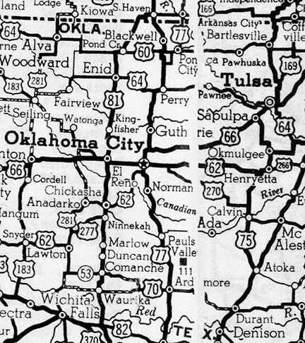
All across the country during the 1930s, many new US routes were created and several existing US routes were extended.  If during that timeframe Oklahoma had tried to address their concerns by getting one or two new north-south routes, they probably would have been successful.  But for whatever reason, it appears they did not make an attempt during those early years.  Already by the 1940s AASHO had become much more particular about new additions to the US route system.  And it wasn't until 1952 that Oklahoma started trying to extend some north-south US routes through the central part of the state.  That was the year when Oklahoma proposed extending the US 377 designation along the corridor shown in green on this map:

Get your very own map showing all current and historic US routes!
(Note: thicker lines represent corridors that were eventually signposted as US routes.  Thinner lines were proposed but never signed.)  Below is the entry for the proposal from an Oklahoma DOT document showing US 377's revision history:
Picture
I have not seen any documents stating why AASHO denied that proposal, but I will suggest a couple possible reasons:
  • At the time, US 177 did not go through Ponca City, so this arrangement would have resulted in the south terminus of one route (US 177) only about 20 miles from the north end of another (US 377).  AASHO probably would have encouraged Oklahoma to combine the two routes.
  • At that time, the north end of US 377 was in Denton TX, so in order for AASHO to approve this proposal, Texas would have had to agree to extend the designation north to the Oklahoma line.  It is unknown whether Oklahoma tried to obtain Texas' cooperation, but...

...one of the reasons I suspect Oklahoma did not seek buy-in from Texas is that, just four months later, they submitted another request to AASHO.  This proposed route was nearly identical to the first one, except this time Oklahoma addressed both of the issues above: it was the US 177 designation (instead of US 377) that they proposed extending, and the south terminus would have been at US 70 in Dickson, so there was no need for cooperation with any other state:
Picture
I do not know why AASHO rejected that proposal (nor what changes may have taken place between then and 1965, at which time AASHO changed their position and did approve that extension of US 177, as we will see below).  At any rate, the following year (1953), Oklahoma proposed extending US 377 again, but this was along a different corridor running all the way between the north and south state lines:
Picture
On the map above, that route would have followed the red and purple segments.  But again, to make the south end of that idea work, Texas would have had to extend US 377.  And on the north end, AASHO probably would not have allowed a US route to end at a state line, but to my knowledge Kansas had no interest in the US 377 designation.

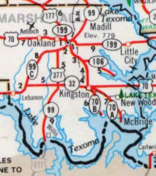
I believe Oklahoma's main goal with these proposed extensions of US 377 was to have a US route serving Ada.  After a few rejections, the next approach they tried was to extend the US 169 designation south from Glenpool (outside Tulsa):
Picture
That route would have followed the blue and purple segments on the map above.  Over 80 miles would have been concurrent with US 75, and within that stretch there also would have been a 20-mile triple-overlap with US 62.  Perhaps that is why the proposal was rejected; at any rate the following year Oklahoma tried again...
Picture
...and was rewarded with another rejection.  Their next US 169 entry, from the following year, is interesting and perplexing:
Picture
The entire stretch from Glenpool to Henryetta was already essentially served by US 75, and the segment between Okmulgee and Henryetta additionally carried the US 62 designation.  So why did Oklahoma want US 169 to be overlapped along that route?  And why did AASHO agree to it?  In fact, did they actually agree to it? 

Regarding the reason why Oklahoma wanted to extend US 169 to Henryetta: this is just a theory, but in 1959 the road that would eventually become the Indian Nation Turnpike was at least proposed, if not already under construction south of Henryetta.  It is possible that Oklahoma was originally planning to extend the US 169 designation along that road.

If so, then why might they have signposted the extension absent AASHO's approval?  In light of all the rejected proposals earlier that decade, Oklahoma might have determined that they could not count on AASHO to support their plans.

To be clear, I have no evidence that AASHO did not approve of the extension, but considering their previous disapprovals it would be surprising if they allowed it.  Moreover, I have never seen any map -- not even an official OKDoT map -- that shows a US 169 marker south of Glenpool... as if they were trying to keep it secret.

At any rate, I am quite certain that Oklahoma signed US 169 down to Henryetta, because a few years later they truncated the designation back to Tulsa...
Picture
...and I have seen documents instructing crews to remove US 169 signs between there and Henryetta.  But what was the reason for this odd truncation that came only a few years after the extension?  I can offer only theories:
  • If indeed the extension to Henryetta was done without AASHO approval, then they may have strongly suggested that Oklahoma reverse their action.
  • Oklahoma may have decided the Indian Nation Turnpike was going to be funded by tolls, and AASHO would not have allowed them to extend a US route along a toll road without a free alternative, so there was no longer a need to have US 169 all the way down in Henryetta.
  • In Tulsa, the Mingo Valley Expressway was planned and/or under construction during this timeframe, and transportation planners may have decided they were going to re-purpose the US 169 designation for that route.
Whatever the actual reasons were, the scenario in that last point did eventually happen.  The rest of US 169's history in Tulsa is outside the scope of this page, but more information can be found on the main US 169 page. 

At this point we will backtrack a few months and note that AASHO actually did approve one of Oklahoma's proposed extensions:
Picture
Ignoring the misspelling of Dickson, that was identical to the 1952 proposal.  It is unknown what happened during that 13-year interval that prompted AASHO to relent and approve the same application that they had previously denied.  The remainder of US 177's history in Oklahoma can be found on the main US 177 page.

Now we will backtrack one more year to view another of Oklahoma's proposals to extend US 377:
Picture
That was the same as the 1953 proposal, except instead of going all the way up to Kansas, US 377 would have ended at its junction with US 64 near Cleveland.  It is unclear why Oklahoma decided not to include in their proposed extension the segment of OK 99 between Cleveland and the junction with US 60 in Pawhuska.  But the question is academic, because this proposal was denied.  At that time, Texas has still not extended US 377 north of Denton.  But that finally happened four years later, when AASHO approved an extension of US 377 from Denton to Madill:
Picture
At first glance, that might seem like a small victory for Oklahoma.  However, when one looks at what they actually requested from AASHO, and compares that to what AASHO approved, it seems quite possible that Oklahoma viewed it as more of an insult.  The image below is from the meeting minutes of AASHO's Special Committee on Route Numbering.  It shows the proposal that was submitted, along with a decision regarding which segment of the extension was approved:
Picture
In other words, Texas got all of what they asked for, but Oklahoma was told that US 377 must terminate at its first junction with another US highway, just 16 miles into the state.  Why was AASHO willing to extend US 377 for Texas, but not for Oklahoma?  Hard to say, but it is interesting to note that for the next 20 years Oklahoma did not bother to add a US 377 marker between Madill and the Red River on their state highway map, but instead left it marked simply as OK 99:
Picture
c. 1989
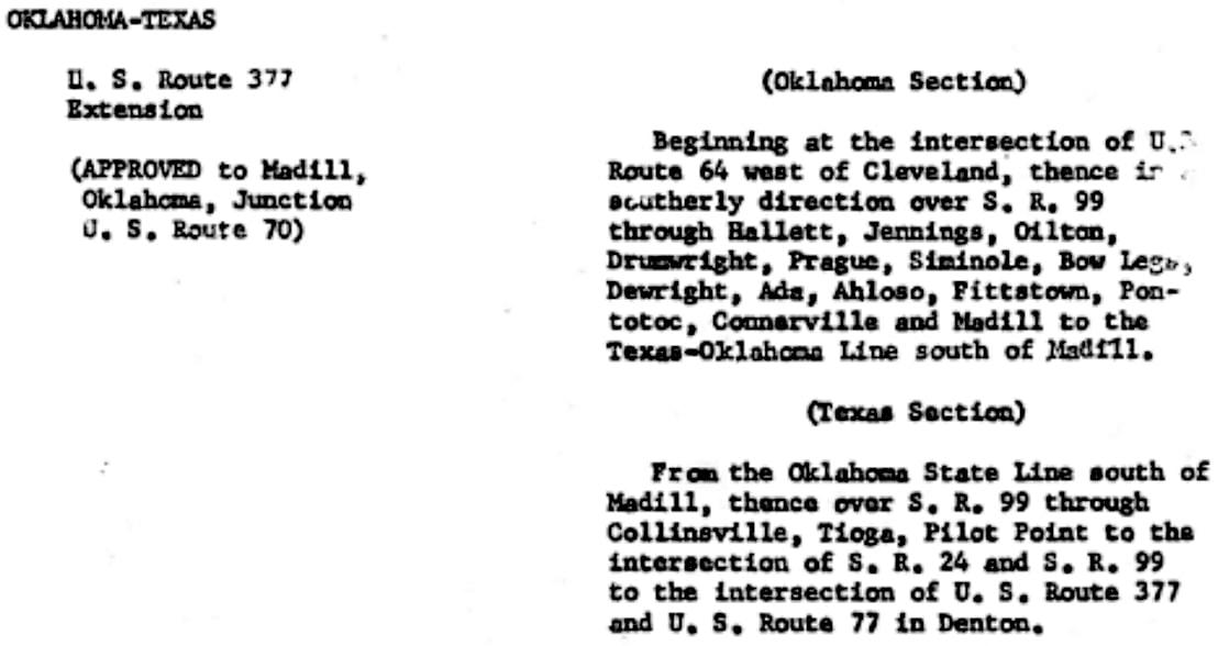
This suggests the possibility that Oklahoma did not immediately sign US 377 in their state; they may have been waiting until their full request was approved.  At any rate, Oklahoma did not waste time applying for permission to extend the US 377 designation further north from Madill.  Again.  And again.  And again... multiple times over the next 10+ years:
Picture
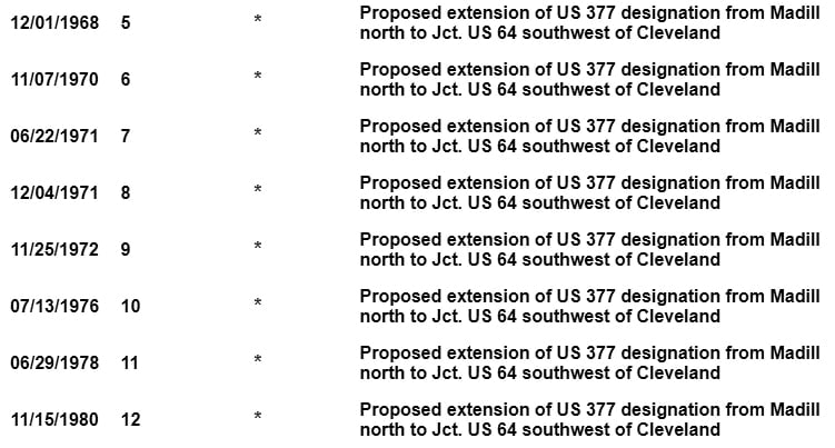
Why did AASHO (AASHTO as of 1973) keep denying Oklahoma's request?  I have seen a few OKDoT documents related to this: one stated that an extension was not approved because the road in question needed improvements in order to be considered compliant with standards for a primary route.  But another stated that the amount of US routes in that part of Oklahoma was too dense.  Whatever the reasons might have been, why did Oklahoma keep submitting the same request, over and over?  Had they been making changes to the road that they expected would cause AASHO to change their answer?  Something finally prompted them to stop asking after 1980 -- presumably the realization that nothing was going to make a difference with AASHTO.  It is unknown what (if anything) happened with this situation over the next 7-8 years.  But what Oklahoma did in 1988 was almost* without precedent: they unilaterally decided to extend a US route without AASHTO approval.  The following is a line from their highway revision list for US 377:
Picture
Not long after that, Oklahoma's state highway map was updated to show the new extension to Stroud, and that was also the first time the map showed a US 377 marker between Madill and the Texas line:
Picture
c. 1989 (a later edition than the one shown above?)
It is unknown how much Oklahoma publicized the fact that they had thumbed their nose at AASHTO, but certainly by the time of the 2002 route log for US 377 (shown below), they were being perfectly upfront about it:
Picture
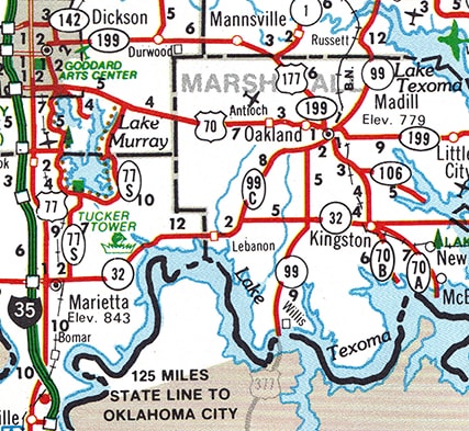
That 120-mile extension of US 377 is without a doubt the single most blatant example of an AASHTO policy violation.  And it is not a good precedent: the uniformity and integrity of the US route system depends on the voluntary cooperation of the state highway departments.  But with that said -- after reading the long history of Oklahoma's multiple requests and AASHTO's chronic denials -- one can easily see why Oklahoma decided to go rogue and signpost the route without approval.  The north end of US 377 (at least according to Oklahoma) is still in Stroud; photos from there can be viewed on the main US 377 page.

* See US 4.
Sources:
US 169 revision history (ODoT)
US 177 revision history (ODoT)
US 377 revision history (ODoT)
US 377 highway revisions (ODoT)
US 377 route log (ODoT)
Official state highway maps (ODoT)
2 Comments
Robert B
9/19/2021 11:08:14 am

Is AASHTO even relevant anymore, in the context of maintaining a logical system of inter-state highway route designations? I'd cite Interstate highways 69E, 69W, and 69C (aka 69WTF) as examples. I can't imagine any serious planner thinking 69C is a good idea, just because a few small towns can't bear being assigned a three-digit highway number. I wonder if Texas used Oklahoma as a threat - approve it, or we'll post it anyway?

I used to live in Hominy, OK, on SH 99, and didn't know the route was part of the beginning of the end of a consistent numbering system. I'd have been rooting for them to run US 377 all the way to the border, so I could do my mid-80s teenage beer run to Kansas on an official US route!

Reply
Tom Ketchum
9/21/2021 05:59:39 am

AASHTO can’t control Congress, and when Congress writes a number into the spending bill, it is the number.

Reply

Your comment will be posted after it is approved.


Leave a Reply.

    RSS Feed

    Author

    This guy.

    Categories

    All
    Arizona
    Boston
    California
    Colorado
    Denver
    Florida
    Geo-center
    Geography
    Historic
    Idaho
    Illinois
    Indiana
    Kansas
    Kentucky
    Maryland
    Massachusetts
    Michigan
    Midpoint
    Mileage
    Minnesota
    Missouri
    Nebraska
    New Hampshire
    New Jersey
    New Mexico
    Newport
    New York
    North Carolina
    North Dakota
    Numbering
    Oddity
    Ohio
    Oklahoma
    Oregon
    Pennsylvania
    Proposed
    Renumbering
    Signage
    South Carolina
    South Dakota
    Tennessee
    Texas
    Updates
    US 101
    US 127
    US 13
    US 136
    US 150
    US 154
    US 16
    US 160
    US 163
    US 164
    US 169
    US 177
    US 180
    US 183
    US 190
    US 191
    US 20
    US 210
    US 212
    US 218
    US 220
    US 23
    US 24
    US 25
    US 259
    US 26
    US 266
    US 27
    US 270
    US 271
    US 277
    US 281
    US 283
    US 285
    US 287
    US 3
    US 31
    US 311
    US 321
    US 34
    US 36
    US 360
    US 371
    US 377
    US 383
    US 385
    US 40
    US 400
    US 411
    US 450
    US 46
    US 48
    US 491
    US 50
    US 530
    US 55
    US 59
    US 6
    US 60
    US 61
    US 62
    US 63
    US 65
    US 66
    US 666
    US 67
    US 730
    US 74
    US 77
    US 80
    US 81
    US 83
    US 84
    US 85
    US 87
    US 89
    US 93
    US 94
    US 96
    US 99
    Utah
    Virginia
    Washington
    Watersheds
    West Virginia
    Wyoming

    Archives

    March 2023
    February 2023
    January 2023
    August 2022
    March 2022
    February 2022
    January 2022
    August 2021
    July 2021
    June 2021
    April 2021
    February 2021
    January 2021
    August 2020
    July 2020
    May 2020
    April 2020
    March 2020
    February 2020
    January 2020
    December 2019
    October 2019
    September 2019
    August 2019
    May 2019
    January 2019
    November 2018
    June 2018
    April 2018
    March 2018
    November 2017
    September 2017
    August 2017
    June 2017
    March 2017
    February 2017
    January 2017
    December 2016

Copyright © 1998-2023
Picture