Background: split US routes
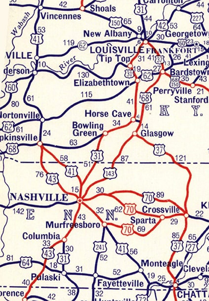
When the Bureau of Public Roads was planning the US route system in the mid-1920s, most local leaders wanted a US highway to pass through their town, because they recognized that such a designation would bring the perception of prestige and the potential for economic gain. Drivers traveling between two larger cities often had more than one route available to them, each having comparable distance, road surface quality, etc. Towns situated along the optional routes sometimes clashed over which route should be awarded a US designation, and sometimes these fights were so bitter that the state departments of transportation could not resolve them. So instead they pushed BPR to designate split routes as a compromise measure, and BPR allowed it as a way to get the states to accept their proposed route numbering system. The following maps illustrate some examples of split routes. At the top of this first map, US 31 was shown heading south through Indiana, but just north of Louisville it split into two branches, designated US 31-E and US 31-W: 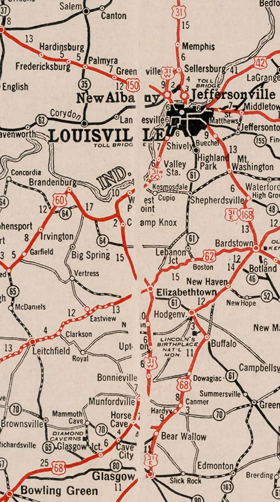
c. 1934, Rand McNally
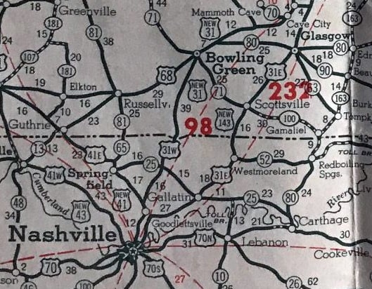
Southward from Louisville the two routes followed essentially parallel corridors, but US 31-W passed through Elizabethtown and Bowling Green, while US 31-E traffic was directed through Bardstown and Glasgow. This next map shows the remainder of those routes, continuing southwest from Bowling Green and Glasgow (now at upper right) to Nashville:
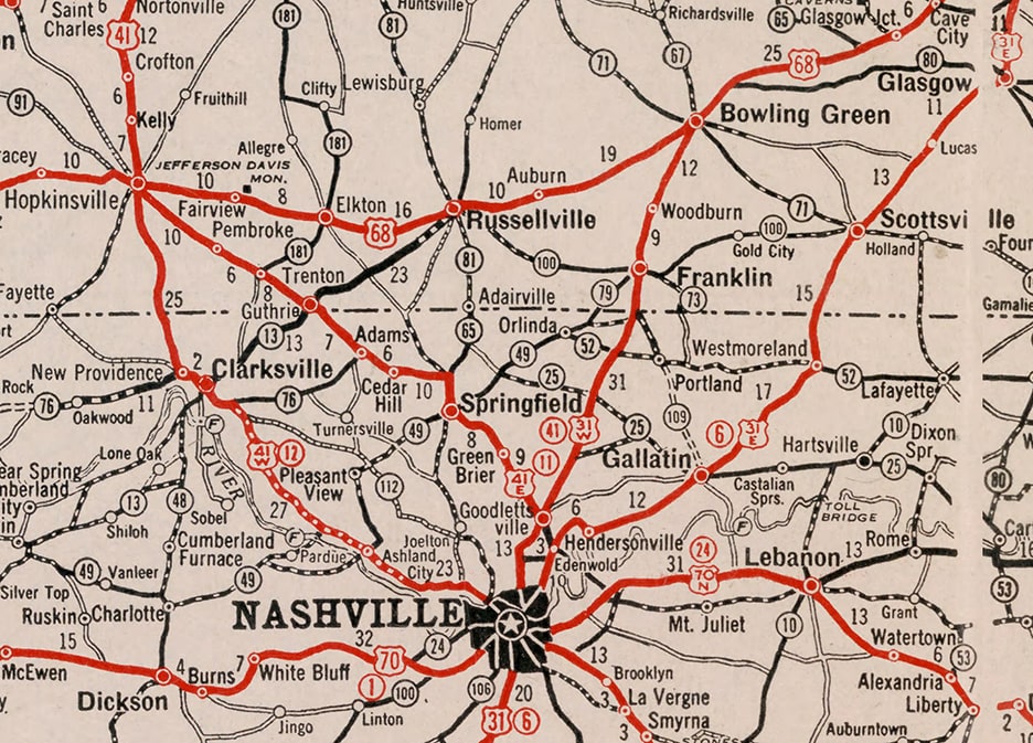
c. 1934, Rand McNally
The remainder of US 31-W went through Franklin, whereas US 31-E passed through Gallatin. The two converged in Nashville and continued further south as a re-unified US 31. Another split route is illustrated on that map: US 41 between Nashville and Hopkinsville split into US 41-W (via Clarksville) and US 41-E (via Springfield).
Once BPR had finalized the US routes, it handed control of the system over to a different organization, the American Association of State Highway Officials. AASHO soon started receiving feedback that the split routes were causing confusion to drivers. As an example, the photo below was submitted to AASHO by the Indiana Dept. of Transportation, along with a letter complaining about the confusion caused by split routes across the Ohio River in Louisville. They pointed out that this image was taken looking east on a road which was also northbound on a highway designated US 31 West: 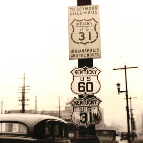
c. 1935, INDoT
(It is also interesting to note the non-standard Indiana US 31 sign, which was probably posted by INDoT, although it is unclear why Kentuckians would allow that in Louisville.) AASHO had started encouraging the state DOTs to eliminate their split routes, by using one of two conventions.
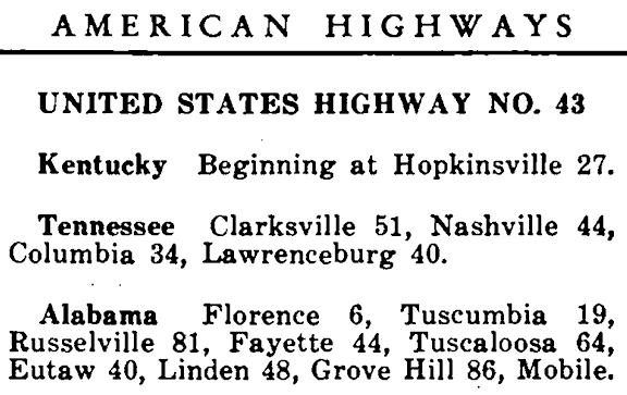
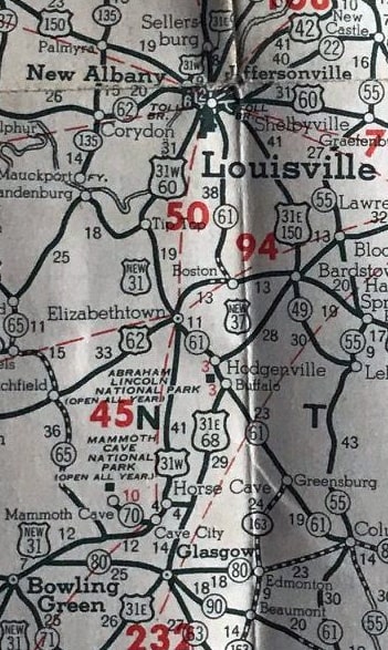
AASHO's proposal to eliminate the US 31 split routes In cases where state DOTs were not making progress eliminating their split routes, AASHO stepped in and offered their own solutions. AASHO's proposal for the aforementioned US 31 and US 41 splits were announced to the public through a route log published in the Oct. 1934 issue of American Highways, and for that reason their suggested routes were shown on some maps (both government and commercial). We will use one such map to illustrate AASHO's proposal. However, it was a bit complicated, so we'll break it down using a series of smaller sections of the map. First, let's see how AASHO proposed to address the US 41 split. At the time, US 43 ended at the Alabama/Tennessee line just north of Florence (at bottom of this map). AASHO proposed to extend this designation north to Columbia (note "New 43" shields) and then continue to Nashville overlapped with US 31. From there, US 43 would replace US 41-W through Clarksville to Hopkinsville, and the former US 41-E would become vanilla US 41: 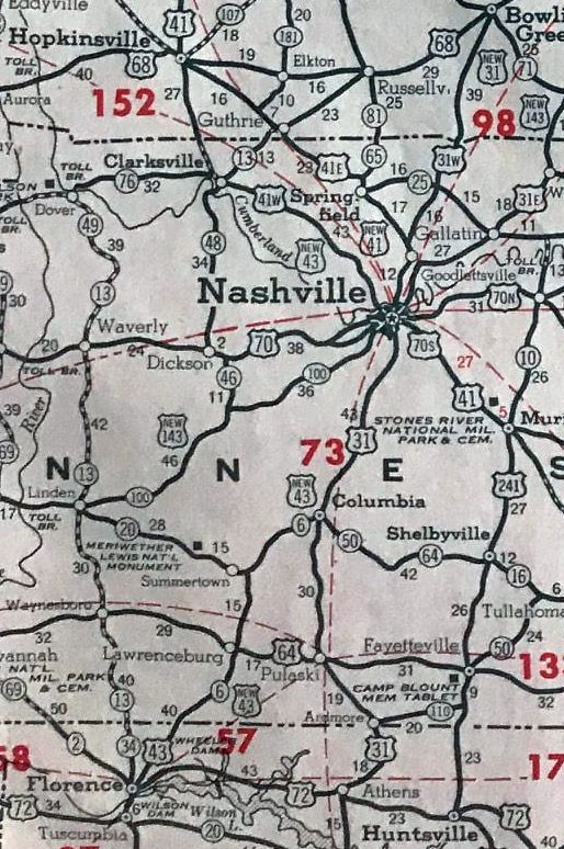
c. 1939, Gousha
That was based on the 1934 route log, which described US 43 as running between Hopkinsville KY and Mobile AL:
Next, let's take a look at AASHO's proposal for addressing the US 31 split routes. Staring in Louisville and heading south, US 31-E would become US 37, while US 31-W would become vanilla US 31...
c. 1939, Gousha
...however, US 37 followed US 31-E only as far as Glasgow. From there, US 37 traffic was to be directed along a corridor not previously included in the US route system. It was to follow KY 90 to the Tennessee line, then TN 28 all the way down to Chattanooga, as shown here:
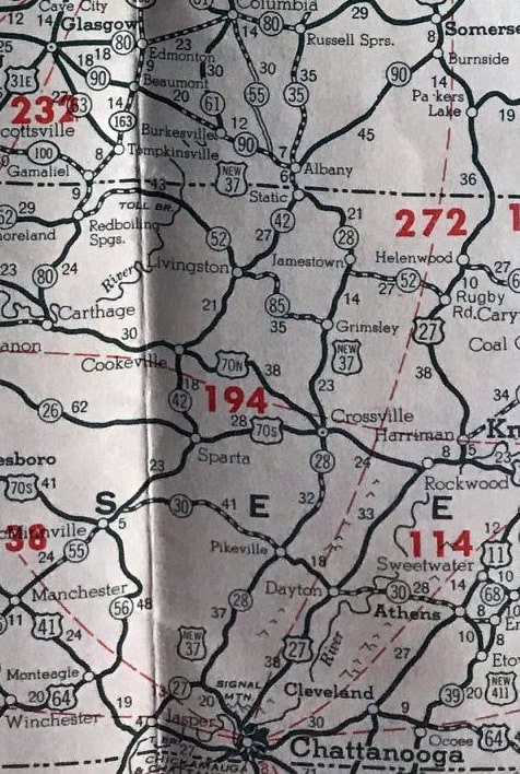
c. 1939, Gousha
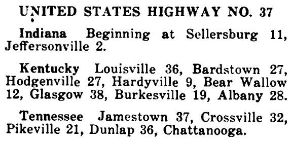
That was based on the same route log, which included the US 37 designation, running between Sellersburg IN and Chattanooga TN:
So that leaves the question: what did AASHO plan to do with the segment of US 31-E between Glasgow and Nashville? That segment was to be assigned a new number: US 143. This number implied that it was a branch route off US 43, to which it would connect in Nashville:
c. 1939, Gousha
Here is the description of that route, as given in the 1934 log:

To wrap up this section, here is a different, smaller-scale map that showed an overview of each of these proposed routes:
c. 1936
Kentucky pushes back
Now, let us recall the reason split routes were created in the first place: to appease local interests who did not want to be left off what they perceived to be "the main highway". That factor had not changed, and it was still a cause for concern. For example, a town that was formerly located on US 31-E might not want their highway to be changed to some "lesser" route that was much shorter than US 31. Some towns in Kentucky actually did lobby their state DOT not to allow any changes to the US 31 split routes, and the Kentucky Transportation Commission acquiesced by refusing to implement AASHO's proposal. Below is an excerpt from a January 1935 letter sent from AASHO to KYTC: 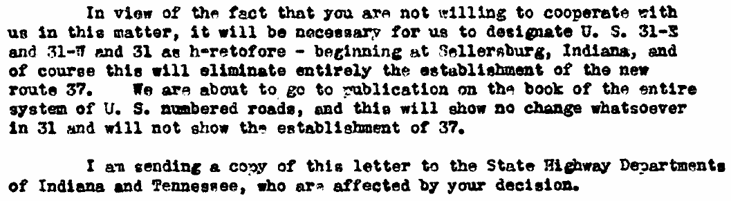
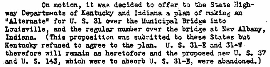
Also in Jan. 1935 AASHO recorded in their meeting minutes KYTC's rejection of their offer as follows:
In Feb. 1935 AASHO informed a commercial mapmaker that their proposed solution to the US 31 split routes should not be published:
Despite that, apparently not all mapmakers received the memo (as we have seen above), or else they had already gone to press with maps that prematurely showed US 37 and US 143. Just four months after the 1934 route log was published, AASHO printed an updated version of their route log in booklet format (the March 1935 issue). Already by then, the entries for both US 37 and US 143 had been removed. However, AASHO did not change their description of US 43; they continued to list Hopkinsville as the northern terminus all the way until 1952 (even though US 43 was never signposted north of Columbia TN).
The US 37 designation was shown on the 1935 and '36 issues of INDoT's official state highway map (which showed a small section of Kentucky around Louisville). Surely INDoT was aware that KYTC had not implemented AASHO's proposal for US 37, but perhaps putting it on their map was their way of encouraging KYTC to reconsider: 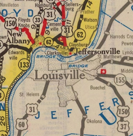
c. 1935, INDoT
Apparently INDoT gave up by 1937, because their map of that year no longer showed US 37. Eventually (sometime around 1980) Indiana did eliminate the US 31 split from their state: south from Sellersburg, US 31-W was redesignated as a state route, and the former US 31-E became vanilla US 31. But Kentucky has kept the split routes to the present day. Since about 1980 the split of US 31 into US 31-E and US 31-W occurs right in downtown Louisville (although it should be noted that the routes are very inadequately signposted in that area).
In contrast with Kentucky's refusal to eliminate the US 31 split routes, way back in 1943 they did agree to change the US 41 split routes between Nashville and Hopkinsville (although their solution was different than AASHO's proposal to extend US 43). The former US 41-E is now vanilla US 41, and the former US 41-W is now Alternate US 41.
Research and/or image credits: Mike Roberson, Dale Sanderson
0 Comments
Your comment will be posted after it is approved.
Leave a Reply. |
AuthorCategories
All
Archives
July 2024
|

 RSS Feed
Copyright © 1998-2024
