US Ends .com
  • Home
  • Store
    • US highway book
    • US highway map
    • Florida US highway map
  • Endpoints
    • US 1 - US 9 >
      • 1 >
        • 201
        • 301
        • 401 [i]
        • 401 [ii]
        • 401
        • 501
        • 601
        • 701
      • 2w >
        • 102
      • 2e >
        • 202
        • 302
      • 3
      • 4 >
        • 104
      • 5
      • 6 >
        • 106
        • 206
      • 7
      • 8
      • 9 >
        • 109*
        • 209
        • 309
    • US 10 - US 19 >
      • 10 >
        • 110
        • 210
        • 310
        • 410
      • 11 >
        • 111
        • 211
        • 311
        • 411 [i]
        • 411 [ii]
        • 411
        • 511*
        • 611
        • 711*
      • 12 >
        • 112
        • 212
        • 312
      • 13 >
        • 113
        • 213
      • 14
      • 15
      • 16 >
        • 116
        • 216
      • 17 >
        • 17-1
        • 117 [i]
        • 117
        • 217
      • 18 >
        • 118
        • 218
      • 19 >
        • 119
        • 219
        • 319
    • US 20 - US 29 >
      • 20e >
        • 120
        • 220
        • 320
        • 420
      • 20w
      • 21 >
        • 121 [i]
        • 121
        • 221
        • 321
        • 421
        • 521
      • 22 >
        • 122 [i]
        • 122 [ii]
        • 222
        • 322
        • 422e
        • 422w
        • 522
        • 622*
      • 23 >
        • 123 [i]
        • 123
        • 223
      • 24 >
        • 124
        • 224
      • 25
      • 26 >
        • 126
      • 27 >
        • 127
        • 227
      • 28
      • 29 >
        • 129
    • US 30 - US 39 >
      • 30 >
        • 130
        • 230
        • 330
        • 430
        • 530
        • 630*
        • 730
        • 830
      • 31 >
        • 131
        • 231
        • 331 [i]
        • 331
        • 431
      • 32
      • 33
      • 34
      • 35
      • 36 >
        • 136
      • 38 >
        • 138
    • US 40 - US 49 >
      • 40 >
        • 140
        • 240
        • 340
      • 41 >
        • 141
        • 241 [i]
        • 241 [ii]
        • 341
        • 441 >
          • 441n
          • 441s
        • 541
        • 641
      • 42
      • 43
      • 44
      • 45
      • 46
      • 48 [i]
      • 48 [ii]
      • 48
      • 49
    • US 50 - US 59 >
      • 50 >
        • 150
        • 250
        • 350
        • 450
        • 550
        • 650
      • 51 - 55 >
        • 51 >
          • 151
        • 52 >
          • 152
        • 53
        • 54 >
          • 154
        • 55
      • 56 >
        • 156
      • 57
      • 58 >
        • 158
        • 258
      • 59 >
        • 159
        • 259
    • US 60 - US 69 >
      • 60 >
        • 160
        • 260
        • 360
        • 460
      • 61 - 65 >
        • 61 >
          • 161
        • 62
        • 63 >
          • 163 [i]
        • 64 >
          • 164 [i]
          • 164 [ii]
          • 264
        • 65 >
          • 165
      • 66 >
        • 166
        • 266
        • 366 [i]
        • 366 [ii]
        • 466 [i]*
        • 466 [ii]
        • 566
        • 666
      • 67 >
        • 167
      • 68 >
        • 168
      • 69 >
        • 169
    • US 70 - US 79 >
      • 70 >
        • 170
        • 270 [i]*
        • 270
        • 370
        • 470
      • 71 >
        • 171
        • 271
        • 371 [i]
        • 371 [ii]
        • 371
      • 72 - 76 >
        • 72
        • 73
        • 74
        • 75 >
          • 175
          • 275
        • 76 >
          • 176
          • 276
      • 77 >
        • 177
        • 277
        • 377
      • 78 >
        • 178
        • 278
        • 378
      • 79
    • US 80 - US 89 >
      • 80 - 84 >
        • 80 >
          • 180 [i]
          • 180
          • 280
          • 380
        • 81 >
          • 181
          • 281
        • 82
        • 83 >
          • 183
          • 283
          • 383
        • 84
      • 85 - 89 >
        • 85 >
          • 185
          • 285 [i]
          • 285
          • 385 [i]
          • 385
          • 485
        • 87 >
          • 187
          • 287n
          • 287s
        • 89n
        • 89s >
          • 189 [i]
          • 189
    • US 90 - US 99 >
      • 90 - 94 >
        • 90 >
          • 190
          • 290
        • 91 >
          • 191 >
            • 191n
            • 191s
          • 491
        • 92 >
          • 192
        • 93
        • 94
      • 95 -98 >
        • 95 >
          • 195
          • 295
          • 395
        • 96 [i]
        • 96
        • 97 >
          • 197
        • 98
      • 99 >
        • 199
        • 299
        • 399
    • Anomalies >
      • 101
      • 163
      • 400
      • 412
      • 425
  • Places
    • A-L >
      • A >
        • Aberdeen
        • Albuquerque
        • Amarillo
        • Apalachicola
        • Astoria
        • Atlantic
      • B >
        • Baltimore
        • Baton Rouge
        • Bay Area
        • Bishop
        • Boone
        • Brady
        • Bristol
        • Brownsville
        • Brunswick
      • C >
        • Charleston
        • Chattanooga
        • Chicago
        • Cincinnati
        • Cleveland
        • Cody
        • Corpus
        • Cortez
        • Council Bluffs
        • Covington
        • Crescent
        • Cumberland Gap
      • D-E >
        • Dallas
        • Des Moines
        • Detroit
        • Dothan
        • Douglas
        • El Paso
        • Erie
        • Eugene
      • F >
        • Farmington
        • Flagstaff
        • Florence
        • Fox Valley
        • Franklin
      • G >
        • Gallup
        • Georgetown
        • Grand Junction
        • Grand Portage
        • Grayling
        • Great Falls
        • Greeley
      • H-I >
        • Hardeeville
        • Harrisburg
        • Holbrook
        • Idaho Falls
        • Int'l Falls
      • J-K >
        • Jacksonville
        • Joplin
        • Junction
        • Kansas City
        • Keokuk
        • Key West
        • Kingman
      • L >
        • Laredo
        • Lewiston
        • Long Beach
        • Los Angeles
        • Louisville
        • Lubbock
    • M-R >
      • M >
        • Mackinaw
        • Madison
        • Maryhill
        • Maysville
        • Miami
        • Midway
        • Miles City
        • Milford
        • Milwaukee
        • Minneapolis
        • Mobile 31
        • Mobile 31-43-45
        • Montgomery
        • Monticello
        • Mount Vernon
      • N-O >
        • Nags Head
        • Naples
        • Natchez
        • New Castle
        • New Orleans
        • Niagara
        • Norlina
        • Ocean City
        • Oklahoma City
      • P >
        • Pee Dee
        • Pembina
        • Pensacola
        • Petersburg
        • Philadelphia
        • Piegan
        • Pineville
        • Port Arthur
        • Portsmouth
      • Q-R >
        • Quad Cities
        • Rapid City
        • Raton
        • Reading
        • Richmond
        • Rockingham
        • Rouses Point
    • S-Z >
      • S >
        • San Antonio
        • San Antonio NM
        • San Diego
        • Santa Fe
        • Savannah
        • Sioux
        • Springer
        • Springfield
        • St. Ignace
        • St. John
        • St. Paul
        • St. Pete
      • T-U-V >
        • Tallahassee
        • Tampa
        • Toledo
        • Trinidad
        • Tuba City
        • Ucolo
        • VA Beach
      • W >
        • Walterboro
        • Waverly
        • West Memphis
        • Wilmington
        • Wilson
        • Wrightsville
      • Y >
        • Yellowstone E
        • Yellowstone N
        • Yellowstone NE
        • Yellowstone S
        • Yellowstone W
  • Highways
    • Map of all endpoints
    • Sources
    • History
    • 1926 almost-routes
    • Intra-state routes
    • Numbering
    • Colors
    • Gaps
    • Blog
  • Bonus
    • Colorado >
      • Lowest point
      • Antipodes
      • Toponymy >
        • Roots
      • Colloquialisms
      • Populations
      • Denvers
    • Washington Meridian
    • Watersheds >
      • Headwaters Hill
      • Three Waters Mtn.
      • Parting of the Waters
    • Geo-centers >
      • 48 states
      • 50 states
      • North America
    • State corners >
      • AZ-CO-NM-UT
      • CO-UT-WY
      • CO-NE-WY
      • CO northeast
      • CO-KS-NE
      • CO-KS-OK
      • CO-NM-OK
      • NM-OK-TX
      • NM southeast
      • TX northwest
  • Connect
    • Author/history
    • Rationale
    • Contact
    • Contributors
    • Submissions

US Highways Blog

How long is US highway 20, really?

1/4/2017

6 Comments

 
(latest revision 8/31/2020)
US 20 is often cited as the longest highway in the country (and that may be correct, although its main challenger is a lot closer than most people realize).  In late 2016, officials from both endpoints (Oregon and Massachusetts) posted twin signs, one at each terminus of the highway (photos and more info on the 
US 20 page).  While that was a really great idea, it is unfortunate that the distance listed on those signs (3365 miles) is off by a non-trivial amount.
Picture
Wayne Brunelle, Nov. 2016
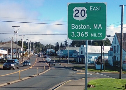
The source for the 3365-mile figure was the AASHTO route log, published in 1989.  But when one actually looks at that log, one finds that in order to reach the cited 3365-mile figure, one must include not only the mileage for mainline US 20, but also the mileages for all of US 20's auxiliary routes (that is, each of the bannered routes with designations like Alternate US 20 and Business US 20).  But obviously those auxiliary mileages must be subtracted out in order to arrive at an accurate total for mainline US 20, which according to the route log would have been only 3237 miles.

​However, when US 20's mileage was referenced in 2016, the AASHTO route log was at least 27 years old, possibly more.  That raised a red flag in my mind, so I checked it out myself and found that the actual mileage is now even less than 3237.  Why would the mileage change after 1989?  Because during those 30-some intervening years, the route of US 20 has been realigned in several places (perhaps most significantly through Iowa, where it is now a freeway across most of that state).  Every time something like that happens, the mileage of US 20 changes.  As of 2020, when adding up recent data from each of the states that US 20 passes through, that total is closer to 3220 miles.
However, I am not convinced even that figure is accurate.  I checked it out with Google Maps, and following are the figures I used in order to come up with my total.*  These mileages are separated by state and/or jurisdiction, which makes it more convenient to compare against the figures listed in the official route logs from each state dept. of transportation:

​153.1 - Massachusetts

371.2 - New York
45.2 - Pennsylvania
260.3 - Ohio
155.4 - Indiana
197.9 - Illinois
300.1 - Iowa
430.5 - Nebraska
432.8 - Wyoming [note 1]
9.7 - Montana [note 2]
401.0 - Idaho
446.1 - Oregon
3203.3 - TOTAL [note 3]

80.1 - National Park Service via Norris Canyon [note 4]
93.8 - National Park Service via South Loop [note 4]

*I should note that some in the highway hobbyist community of which I am a part have disagreed with this practice, arguing that official DOT figures are more reliable than original research using Google maps.  In most cases they are probably right, although I have seen enough mistakes made by DOTs that I am convinced their data cannot always be taken at face value, at least not without a little fact-checking.  
Get your very own map showing all current and historic US routes!
Get your copy of this epic book that commemorates the first century of the US route system!

Notes:
[1] This is the mileage under the jurisdiction of Wyoming DOT, i.e. the mileage between the Nebraska state line and the east entrance to Yellowstone National Park.  This figure does not include the mileage between Yellowstone's east entrance and the Montana state line.  Rather, that mileage is included in the figure for National Park Service.

[2] This is the mileage under the jurisdiction of Montana DOT, i.e. the mileage between the Idaho state line and Boundary Street in the town of West Yellowstone.  This figure does not include the 2.1 miles between Boundary Street and the Wyoming state line.  Rather, that mileage is included in the figure for National Park Service.

[3] US 20 is not signposted within Yellowstone, and technically it does not exist inside the Park boundaries.  So this figure represents the total mileage that is officially designated as US 20. 

[4] However, in order to actually drive US 20 from end-to-end, one must pass through the National Park via some route that connects the east entrance and West Yellowstone.  So for a cross-country trip, we would have to add the mileage under the jurisdiction of the National Park Service.  In other words, the distance between the east entrance to Yellowstone National Park and Boundary Street in the town of West Yellowstone (this figure includes 2.1 miles within Montana, while the remaining mileage is in Wyoming).  The shortest route is via the Norris-Canyon Road, which adds 80.1 miles (as measured between the aforementioned control points).  This would result in a cross-country distance of 3283.4 miles.  However, rather than using Norris-Canyon, some maps suggest that US 20 traffic should instead use the south half of the Grand Loop.  That distance is 93.8 miles (between the same waypoints referenced above).  That is 13.7 miles more than the Norris-Canyon route, which would then yield a total cross-country figure of 3297.1 miles.

So even if we choose to add the cross-country mileage, and we choose the longer route through Yellowstone, we are still 68 miles short of the 3365-mile figure listed on the signs.  And one could argue that the mileage through Yellowstone should not be added at all, which then calls into question whether US 20 is actually the longest highway.

The midway-point along US 20 is in Nebraska.  The exact location is dependent on how one counts mileage through Yellowstone.  Half of 3310 is 1655 miles, so the midpoint of US 20 would be between the towns of Newport and Bassett.  If we go with the shorter distance of 3296, that would shift the midpoint 6.9 miles further west, which is essentially right in Bassett.
Additional research: Mike Roberson
6 Comments
Tom link
3/26/2018 05:46:53 pm

According to GSV (Aug 2013), there is one small mention of US 20 within Yellowstone. Check out EB East Entrance Road just east of its intersection with Grand Loop Road. There is a wooden NPS sign that includes US 20 (and 14). https://www.google.com/maps/@44.5678735,-110.3871702,3a,75y,56.58h,88.53t/data=!3m6!1e1!3m4!1s34I3CGH3j6oteiA-vvSxvQ!2e0!7i13312!8i6656

No other mentions of it that I know of, and definitely still not a signed route through the park. Also, this would suggest the south half of the Grand Loop routing you mentioned.

Reply
Tom Kovar
8/13/2018 03:53:45 am

Very cool! I can live with the uncertainty, regardless. :)

Reply
usends.com link
1/6/2023 04:31:07 pm

Updated GSV imagery is now available, dated Aug. 2022. NPS has since replaced the sign that was shown in the 2013 imagery; the newer sign now references US 14-16, but no longer any mention of US 20! Regardless, in both iterations of the sign, it seems the intent was to say "these numbered routes begin at the east entrance, 26 miles ahead."

Reply
Neal
10/1/2022 11:04:59 pm

Highway 20 has been realigned east of Newport, Oregon around the town of Eddyville recently. The distance has changed from 7.72 miles to 4.66 miles, losing 3.06 from the net distance.

Reply
Isaac Pasley
10/11/2022 10:16:53 am

I think Bassett, NE should market their status as being the halfway point along the longest road. Maybe open up a restaurant called the “Highway 20 Half-Way Café” or something like that.

Reply
Paul Peloquin
1/1/2024 05:53:30 pm

I'd eat there! I have a picture of my motorcycle at the retro Phillips 66 station in Bassett. I loved that trip right up until I hit Chicago!

Reply

Your comment will be posted after it is approved.


Leave a Reply.

    RSS Feed

    Author

    This guy.

    Categories

    All
    Alabama
    Arizona
    Boston
    California
    Colorado
    Denver
    Florida
    Geo-center
    Geography
    Historic
    Idaho
    Illinois
    Indiana
    Kansas
    Kentucky
    Maryland
    Massachusetts
    Michigan
    Midpoint
    Mileage
    Minnesota
    Missouri
    Nebraska
    New Hampshire
    New Jersey
    New Mexico
    Newport
    New York
    North Carolina
    North Dakota
    Numbering
    Oddity
    Ohio
    Oklahoma
    Oregon
    Pennsylvania
    Proposed
    Renumbering
    Signage
    South Carolina
    South Dakota
    Tennessee
    Texas
    Updates
    US 101
    US 127
    US 13
    US 136
    US 150
    US 154
    US 16
    US 160
    US 163
    US 164
    US 169
    US 177
    US 180
    US 183
    US 190
    US 191
    US 20
    US 210
    US 212
    US 218
    US 220
    US 23
    US 231
    US 24
    US 241
    US 25
    US 259
    US 26
    US 266
    US 27
    US 270
    US 271
    US 277
    US 281
    US 283
    US 285
    US 287
    US 3
    US 31
    US 311
    US 321
    US 331
    US 34
    US 36
    US 360
    US 371
    US 377
    US 383
    US 385
    US 40
    US 400
    US 411
    US 431
    US 450
    US 46
    US 48
    US 491
    US 50
    US 530
    US 55
    US 59
    US 6
    US 60
    US 61
    US 62
    US 63
    US 65
    US 66
    US 666
    US 67
    US 730
    US 74
    US 77
    US 80
    US 81
    US 83
    US 84
    US 85
    US 87
    US 89
    US 93
    US 94
    US 96
    US 99
    Utah
    Virginia
    Washington
    Watersheds
    West Virginia
    Wyoming

    Archives

    April 2025
    July 2024
    August 2023
    May 2023
    March 2023
    February 2023
    January 2023
    August 2022
    March 2022
    February 2022
    January 2022
    August 2021
    July 2021
    June 2021
    April 2021
    February 2021
    January 2021
    August 2020
    July 2020
    May 2020
    April 2020
    March 2020
    February 2020
    January 2020
    December 2019
    October 2019
    September 2019
    August 2019
    May 2019
    January 2019
    November 2018
    June 2018
    April 2018
    March 2018
    November 2017
    September 2017
    August 2017
    June 2017
    March 2017
    February 2017
    January 2017
    December 2016

Copyright © 1998-2025
Picture