|
(most recently updated 5/18/2023)
Inspired by Kurumi in an AARoads Forum post, I decided to compile a list of US routes that have been completely moved (or at least mostly moved) from their original alignments. In other words, these routes bear no resemblance (or very little resemblance) to the route that originally carried the same number. A subset of these shape-shifting routes could be considered "Grandfather's Axe highways". Grandfather's Axe highways
That term refers to a philosophical conundrum which posits the question, "If grandfather replaced the head of his axe, and later he replaced the axe handle, is it still the same axe?" One could ask a similar question about some US routes. Imagine a highway that started out along certain corridor, but then the "head" of the route was moved, and later the "tail" of the route was moved, such that the highway no longer served any part of its original corridor. Even though it is still posted with the same route number, can it still be considered the same highway? I will walk through this first example in a detailed manner:
US 601
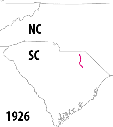
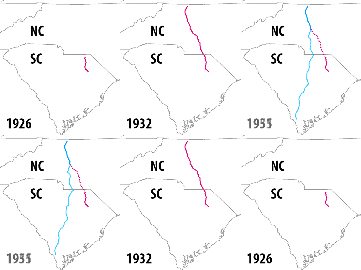
US 601 was commissioned in 1926 as a very short route running between Florence and Cheraw SC:
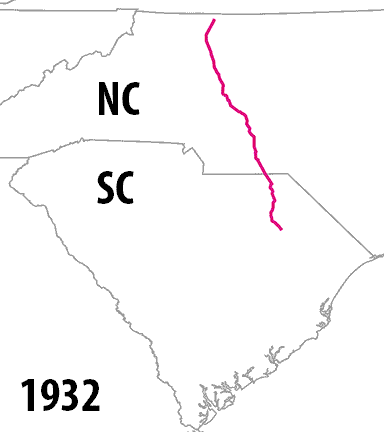
In 1932, the US 601 designation was extended up to Mt. Airy NC:
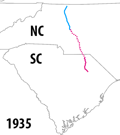
In 1935, US 601 was truncated at Salisbury NC, leaving only the blue segment shown below:
The red segments (both solid and dashed) were replaced by an extension of US 52. Thus once again US 601 became a very short intra-state route, except this time in NC instead of SC. In other words: already by 1935, the entirety of original US 601 (solid red segment) was no longer a part of US 601. So was US 601 still the same highway?
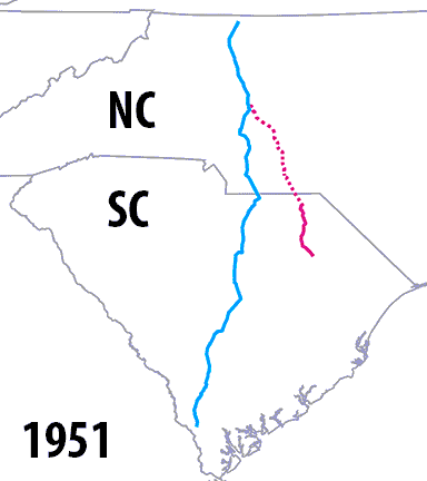
In 1951 US 601 was re-extended into SC, but not along any of its original routing in that state:
Here is an animation that shows each of these changes to US 601 in a single graphic:
So, with that example in mind, following are the qualifications for a "Grandfather's Axe highway":
US 290
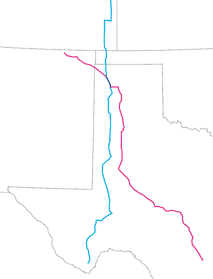
Like US 601, US 290 was also commissioned in 1926, and was also an intra-state route (although significantly longer than US 601). At the time it ran from San Antonio to far west Texas, i.e. the red segments (both solid and dashed) shown on the map below:
In 1935, US 290 was truncated at a point between Harper and Segovia, and the designation was removed from the red dashed segment shown above. Instead of running to San Antonio, US 290 was extended more easterly, to Houston (along the blue segment). So at that point US 290 ran along the solid segments (both red and blue). Then in 1992 the solid red segment was also decommissioned, such that now US 290 runs along only the blue segment, leaving behind the entirety of its original corridor.
US 191
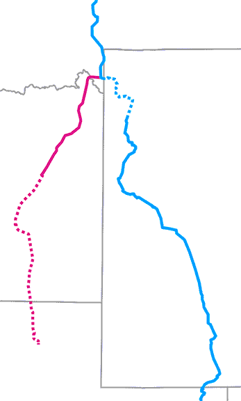
US 191 was commissioned in 1926 to run between Idaho Falls and West Yellowstone (solid red segment on map below):
Before long, US 191 had been extended both to the south (along the dashed red line) and to the north (along the blue line). But around 1980 the US 191 designation was truncated at West Yellowstone and extended south via the blue line, leaving behind its entire original segment (solid red line).
US 141
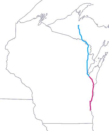
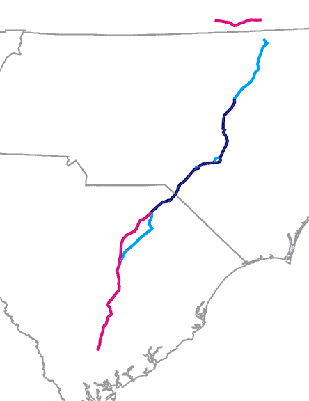
This next example qualifies essentially, but not technically. US 141 was commissioned in 1926 as an alternate route to US 41 between Milwaukee and Green Bay (red segment on the map below):
In 1928, US 141 was extended north into Michigan's upper peninsula (blue segment shown above). Then around 1980 the red segment was decommissioned, such that now US 141 only runs from Green Bay to the north (rather than Green Bay to the south, as it did originally). However, there is an approx. 7-mile segment of US 141 (between Green Bay and Bellevue) that has always been a part of US 141.
So "Grandfather's Axe" highways can cause confusion, because if one were to compare two maps -- the first showing the original version of the route, and the second showing a later iteration of the route which was completely removed from the original corridor -- one could easily get the impression that they were two unrelated routes that just happened to share the same number. While that would not be accurate for the Grandfather's Axe highways described above, there are some US highways for which that actually was the case, and we will look at those next.
Same-numbered US routes that shared common segments
US 180
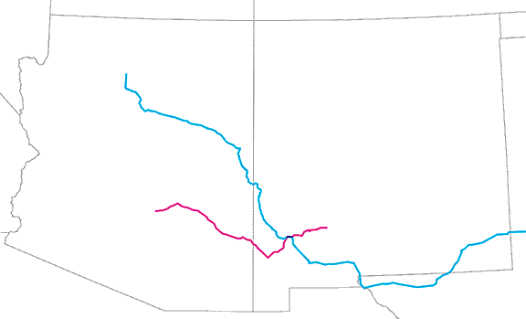
The original US 180 (shown in red on the map below) existed from 1926-1935. Today's US 180 was commissioned in 1943, and in 1961 it was extended into Arizona (the blue route below):
This 1961 extension of the current US 180 overlapped the original US 180 (from three decades earlier) along a 7.5 mile segment between Silver City and Santa Clara NM (shown in purple above, but difficult to see at the scale of that map).
US 385
The original US 385 (shown in red on the map below) also existed from 1926-1935. Today's US 385 was commissioned in 1958. Its southern half is shown in blue on the map below, although it extends all the way up to South Dakota:
Along a 29.5 mile segment between Dalhart and Channing TX (shown in purple above), the 1958 version of US 385 overlapped the original 385 (which had existed in the area three decades earlier).
US 401
There have been three different highways with the designation "US 401":
In other words, a significant portion of today's US 401 runs along a historic segment of US 401[ii] (the stretch between Raleigh NC and Sumter SC). However, there was a 23-year period (from the 1930s to the '50s) during which neither of those designations existed. So it would be hard to make a convincing argument that they were the same highway. On the other hand, it does seem likely that the number 401 was purposely re-used for the current route when it was commissioned in the 1950s, since much of that route had carried that same designation a couple decades earlier.
So those types of US routes can be confusing too, because it is possible to compare two maps -- one created two or three decades later than the first -- that both show the same numbered US route on the same corridor. One might naturally assume they were the same route, but that would actually not be correct, since the designation did not exist continuously along that corridor.
However, most US routes that shared a common number never had any overlapping segments; the remainder of this post will examine those routes. Same-numbered US routes that never had common segments
US 411
Like US 401, the designation "US 411" has also been used on three different routes. But unlike US 401, none of US 411's three iterations ever overlapped.
US 117
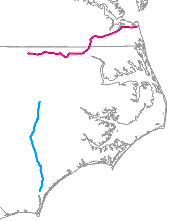
The original US 117 was an east-west route running between Virginia Beach and Norlina NC (shown in red below). It was decommissioned in 1933, and that same year the number 117 was applied to the current route, which runs north-south (shown in blue). Although both iterations of US 117 were in North Carolina, the current US 117 never came very close to the historic US 117[i].
US 121
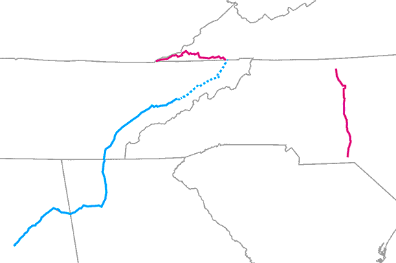
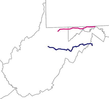
The original US 121[i] existed from 1926-1934 in Virginia and North Carolina (shown in red below). In 2005 the current US 121 was commissioned (although as of 2023 it is still not signposted with US 121 shields). It is eventually supposed to serve a corridor in Virginia and West Virginia (shown in a blue dashed line), but it will not come very close to the original US 121.
US 122
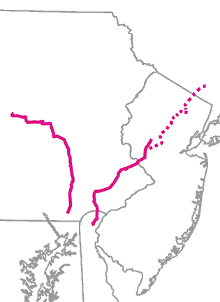
The original US 122[i] ran through DE, PA, and NJ (shown at right on the map below). There was a planned extension into NY (dashed line) which was probably never implemented before the designation was decommissioned in 1934. That same year US 122[ii] (at left) was commissioned as a PA intra-state route:
It is possible that PennDOT requested the US 122 designation so that they could re-use their existing US 122 shields (although I have not seen any documentation to that effect). US 122[ii] lasted until 1963.
US 123
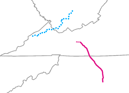
In 1930, when US 23 was rerouted away from the Jenkins-Pineville (KY) corridor, its former segment between those two towns was redesignated as US 123[I] (shown in red on the map below). That lasted only a few years, until US 123 was subsumed by US 119 in 1934. The current US 123 (shown in blue) was commissioned in 1946, but it is in no way related to historic US 123[i].
US 331
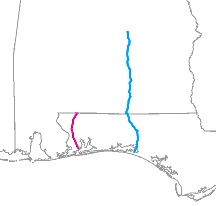
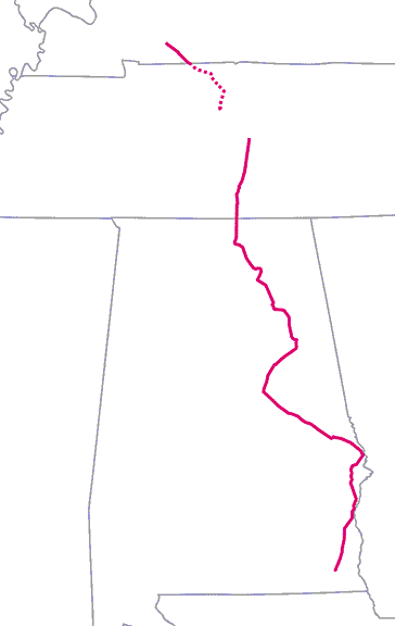
The original US 331[i] was commissioned in 1926 (shown in red below). The current US 331 was commissioned in 1953 (shown in blue):
So both routes numbered US 331 served Florida and Alabama, but they had no relation other than the same designation.
US 241
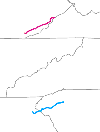
When the US route system was first implemented, there was supposed to be a US 241[i] running between Nashville TN and Hopkinsville KY (shown at the top of the map below). However, Tennessee never signposted the route that way, and it is unclear whether Kentucky did. That route was decommissioned in 1929, and in 1930 US 241[ii] was commissioned to run in TN and AL (shown at bottom):
US 241[ii] lasted until 1953. Despite the fact that one of those routes appears like it could have been an extension of the other, they were actually never connected, and in fact they never existed at the same time.
US 163
When US 63 was rerouted away from Des Moines IA in 1934, the US 163[i] designation was commissioned along its former route, but that lasted only until 1938. That route had no relationship to the current US 163, which was commissioned in 1970 to run in Arizona and Utah (and which should not even have the number "163").
US 164
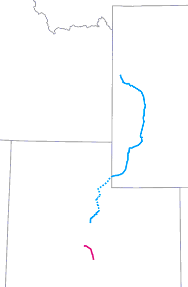
US 164[i] existed from 1928-1930, serving Oklahoma and Texas. It was completely unrelated to US 164[ii] which was also short-lived (1966-1970) and served Arizona and Colorado.
US 366
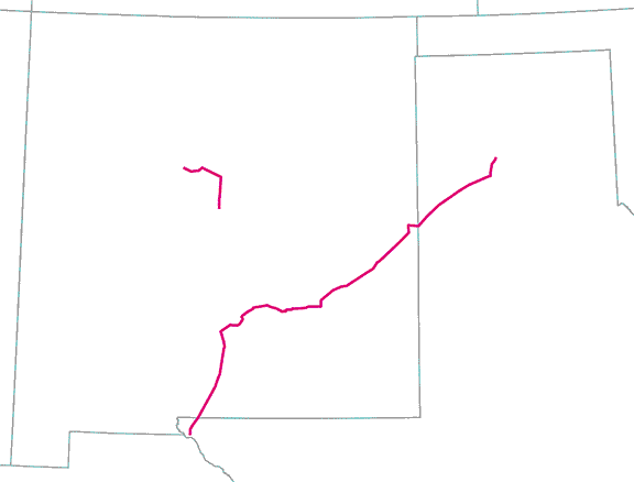
The original US 366[i] connected two major Texas cities (El Paso and Amarillo), although in between the two, most of its mileage was in NM (the longer route shown at right on the map below). It lasted only until 1932. At that time, the US 366[ii] designation was re-used along what had until then been numbered US 470 (the shorter route at left):
Although it is quite possible that NM re-used their old 366 markers on the new 366 route, the two highways were never connected. And US 366[ii] itself was already gone by 1939.
US 270
The US 270 that was commissioned with the original 1926 routes was never signposted in the field. However, I mention it here because it was listed in route logs and shown on some early maps, so I want to point out that it was never related in any way to the current US 270, which runs through AR, OK, and KS.
US 371
There were at least two, and possibly three (it's a long story) routes designated US 371. The first (if it ever actually existed) would have been a very short route running between Poteau OK and Mena AR for a very short time (less than a year). There was definitely a US 371 in Minnesota from 1931-1971. And the current US 371 was commissioned in 1994 in Arkansas and Louisiana. None of them were ever connected or related.
US 285
The original US 285[i] was commissioned in 1926; its south terminus was in Denver. That designation was decommissioned in 1935 (replaced by an extension of US 87), and on the same date the current US 285 was established... which has its north terminus in Denver. US 285[I]'s endpoints were only about two miles away from US 285[ii]'s termini, so without a detailed map it could be easy to mistakenly assume that the two US 285s were connected at some point. For that reason I have put together an interactive map which shows all of the Denver terminus points for both US 285s:
In summary, the original US 285[i] was never connected to the current US 285. They were different routes that not only shared the same number, but also had terminus points very close together. But it would not be surprising at all if in 1935 Colorado took the US 285 route markers from the original highway and reused them on the current route.
US 189
The original US 189[i] was commissioned in 1929, a short Utah intra-state route (shown in red on the map below). In 1939 it was changed to a state route, and that same year the current US 189 designation was established, running between Provo UT and Jackson WY (shown in blue):
In a situation very similar to US 285: since at least part of both routes were in Utah, one could understandably get the impression that the two may have been connected at one time. But in fact they were not, as they never existed concurrently (although it would not be surprising to hear that Utah re-used the old US 189 signs on the new US 189 route).
US 96
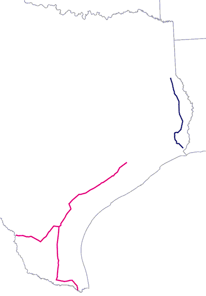
There have been two routes with the designation "US 96". Since both of them were Texas single-state routes, it is easy to assume they were once connected. That was actually not the case, although the two routes were certainly related. The original US 96[i] ran from the Houston area down to the southern tip of Texas at Brownsville (shown in red on the map below, following the southern fork). Later US 96 was rerouted to Laredo instead of Brownsville (western fork). Meanwhile, the southernmost segment of US 59 originally followed the purple line on this map:
But in 1939, the US 59 designation was removed from the purple segment. Instead it was rerouted more southwesterly, connecting with the US 96[i] corridor and replacing that designation to Laredo (red line). The US 96 designation was instead applied to the truncated segment of former US 59 (purple line). So, although the two US 96 routes were related, there was never a time that the two routes existed concurrently, and there was never a segment of US 96 bridging the gap between the two corridors. And while it may have made sense economically for TXDoT to re-use the old US 96 signs on the new US 96 route, the number "96" was not appropriate for a north-south route. A designation of "US 259" would have been more logical, and in fact that could conceivably still be arranged today.
US 48
As that map illustrates, the two most recent US 48 routes were actually somewhat close together, but despite that they were never connected or related in any way, other than sharing a common route number.
1 Comment
8/20/2023 08:48:27 pm
First, I very much appreciate your posting on these "Grandfather's Axe" highways. I'd given some cursory thought to this subject in the past, but your treatment on the topic is, as always, excellent and very thorough. Second, I'll share my perspective and one I've used on my Michigan Highways website in a somewhat similar manner, mostly with regard to what constitutes the history or "shared history" of a specific route. For example, M-118 existed in Michigan for sixty years from 1928–1988 when it was redesignated in its entirety as M-222 to reduce confusion with "similarly-named" 118th St. parallel to M-118 one mile to the north. I consider M-118 to be M-222's direct predecessor and, essentially, the same route but with a different number. Also, while most US Highways in Michigan replaced at least two—and often many more than two—state-numbered routes in 1927, M-16 was replaced by US-16 precisely—same route, same termini, etc. So, while the two technically aren't the same route, I treat M-16 as US-16's direct predecessor with a continuous history. (It also helps that there hasn't been another M-16 designated since 1927!) I also consider many of the US Business Connections which were wholesale converted to Interstate Business Connections (BL, BS) in c.1960 as having an ancestor/descendant relationship. For example, I consider the histories of the BUS US-12 routes in Kalamazoo, Battle Creek, Marshall, etc. as being continuous with those of the BL I-94 routes which took over for them. Also, I consider today's BS I-75 at Bay City to be essentially the same route as the predecessor BL I-75 route which occupies the northern portion of the latter's route. One final example is I also consider the BUS US-127 routings from St Johns, Ithaca, Alma, St Louis, Mount Pleasant, Clare and Harrison to be essentially continuous with each routes' BUS US-27 predecessors. (There are other examples in Michigan, too, but I've made my point.) But, mind you, this is just how *I* see these routes and using different criteria, someone else may have a completely different take.
Reply
Your comment will be posted after it is approved.
Leave a Reply. |
AuthorCategories
All
Archives
July 2024
|

 RSS Feed
