US Ends .com
  • Home
  • Store
    • US highway map
    • Florida US highway map
  • Endpoints
    • US 1 - US 9 >
      • 1 >
        • 201
        • 301
        • 401 [i]
        • 401 [ii]
        • 401
        • 501
        • 601
        • 701
      • 2w >
        • 102
      • 2e >
        • 202
        • 302
      • 3
      • 4 >
        • 104
      • 5
      • 6 >
        • 106
        • 206
      • 7
      • 8
      • 9 >
        • 109*
        • 209
        • 309
    • US 10 - US 19 >
      • 10 >
        • 110
        • 210
        • 310
        • 410
      • 11 >
        • 111
        • 211
        • 311
        • 411 [i]
        • 411 [ii]
        • 411
        • 511*
        • 611
        • 711*
      • 12 >
        • 112
        • 212
        • 312
      • 13 >
        • 113
        • 213
      • 14
      • 15
      • 16 >
        • 116
        • 216
      • 17 >
        • 17-1
        • 117 [i]
        • 117
        • 217
      • 18 >
        • 118
        • 218
      • 19 >
        • 119
        • 219
        • 319
    • US 20 - US 29 >
      • 20 >
        • 120
        • 220
        • 320
        • 420
      • 21 >
        • 121 [i]
        • 121
        • 221
        • 321
        • 421
        • 521
      • 22 >
        • 122 [i]
        • 122 [ii]
        • 222
        • 322
        • 422e
        • 422w
        • 522
        • 622*
      • 23 >
        • 123 [i]
        • 123
        • 223
      • 24 >
        • 124
        • 224
      • 25
      • 26 >
        • 126
      • 27 >
        • 127
        • 227
      • 28
      • 29 >
        • 129
    • US 30 - US 39 >
      • 30 >
        • 130
        • 230
        • 330
        • 430
        • 530
        • 630*
        • 730
        • 830
      • 31 >
        • 131
        • 231
        • 331 [i]
        • 331
        • 431
      • 32
      • 33
      • 34
      • 35
      • 36 >
        • 136
      • 38 >
        • 138
    • US 40 - US 49 >
      • 40 >
        • 140
        • 240
        • 340
      • 41 >
        • 141
        • 241 [i]
        • 241 [ii]
        • 341
        • 441
        • 541
        • 641
      • 42
      • 43
      • 44
      • 45
      • 46
      • 48 [i]
      • 48 [ii]
      • 48
      • 49
    • US 50 - US 59 >
      • 50 >
        • 150
        • 250
        • 350
        • 450
        • 550
        • 650
      • 51 - 55 >
        • 51 >
          • 151
        • 52 >
          • 152
        • 53
        • 54 >
          • 154
        • 55
      • 56 >
        • 156
      • 57
      • 58 >
        • 158
        • 258
      • 59 >
        • 159
        • 259
    • US 60 - US 69 >
      • 60 >
        • 160
        • 260
        • 360
        • 460
      • 61 - 65 >
        • 61 >
          • 161
        • 62
        • 63 >
          • 163 [i]
        • 64 >
          • 164 [i]
          • 164 [ii]
          • 264
        • 65 >
          • 165
      • 66 >
        • 166
        • 266
        • 366 [i]
        • 366 [ii]
        • 466
        • 566
        • 666
      • 67 >
        • 167
      • 68 >
        • 168
      • 69 >
        • 169
    • US 70 - US 79 >
      • 70 >
        • 170
        • 270 [i]*
        • 270
        • 370
        • 470
      • 71 >
        • 171
        • 271
        • 371 [i]
        • 371
      • 72 - 76 >
        • 72
        • 73
        • 74
        • 75 >
          • 175
          • 275
        • 76 >
          • 176
          • 276
      • 77 >
        • 177
        • 277
        • 377
      • 78 >
        • 178
        • 278
        • 378
      • 79
    • US 80 - US 89 >
      • 80 - 84 >
        • 80 >
          • 180 [i]
          • 180
          • 280
          • 380
        • 81 >
          • 181
          • 281
        • 82
        • 83 >
          • 183
          • 283
          • 383
        • 84
      • 85 - 89 >
        • 85 >
          • 185
          • 285 [i]
          • 285
          • 385 [i]
          • 385
          • 485
        • 87 >
          • 187
          • 287
        • 89 >
          • 189 [i]
          • 189
    • US 90 - US 99 >
      • 90 - 94 >
        • 90 >
          • 190
          • 290
        • 91 >
          • 191
          • 491
        • 92 >
          • 192
        • 93
        • 94
      • 95 -98 >
        • 95 >
          • 195
          • 295
          • 395
        • 96 [i]
        • 96
        • 97 >
          • 197
        • 98
      • 99 >
        • 199
        • 299
        • 399
    • Anomalies >
      • 101
      • 163
      • 400
      • 412
      • 425
  • Places
    • A-L >
      • A >
        • Aberdeen
        • Albuquerque
        • Amarillo
        • Apalachicola
        • Astoria
        • Atlantic
      • B >
        • Baltimore
        • Baton Rouge
        • Bay Area
        • Bishop
        • Boone
        • Brady
        • Bristol
        • Brownsville
        • Brunswick
      • C >
        • Charleston
        • Chattanooga
        • Chicago
        • Cincinnati
        • Cleveland
        • Cody
        • Corpus
        • Cortez
        • Council Bluffs
        • Covington
        • Crescent
        • Cumberland Gap
      • D-E >
        • Dallas
        • Des Moines
        • Detroit
        • Dothan
        • Douglas
        • El Paso
        • Eugene
        • Erie
      • F >
        • Farmington
        • Flagstaff
        • Florence
        • Fox Valley
        • Franklin
      • G >
        • Gallup
        • Grand Junction
        • Grand Portage
        • Grayling
        • Great Falls
        • Greeley
      • H-I >
        • Hardeeville
        • Harrisburg
        • Holbrook
        • Idaho Falls
        • Int'l Falls
      • J-K >
        • Jacksonville
        • Joplin
        • Junction
        • Kansas City
        • Keokuk
        • Key West
        • Kingman
      • L >
        • Laredo
        • Lewiston
        • Long Beach
        • Los Angeles
        • Louisville
        • Lubbock
    • M-R >
      • M >
        • Mackinaw
        • Madison
        • Maryhill
        • Maysville
        • Miami
        • Midway
        • Miles City
        • Milford
        • Milwaukee
        • Minneapolis
        • Mobile 31
        • Mobile 31-43-45
        • Montgomery
        • Monticello
        • Mount Vernon
      • N-O >
        • Nags Head
        • Naples
        • Natchez
        • New Castle
        • New Orleans
        • Niagara
        • Norlina
        • Ocean City
        • Oklahoma City
      • P >
        • Pee Dee
        • Pembina
        • Pensacola
        • Petersburg
        • Philadelphia
        • Piegan
        • Pineville
        • Port Arthur
        • Portsmouth
      • Q-R >
        • Quad Cities
        • Rapid City
        • Raton
        • Reading
        • Richmond
        • Rockingham
        • Rouses Point
    • S-Z >
      • S >
        • San Antonio
        • San Antonio NM
        • San Diego
        • Santa Fe
        • Savannah
        • Sioux
        • Springer
        • Springfield
        • St. Ignace
        • St. John
        • St. Paul
        • St. Pete
      • T-U-V >
        • Tallahassee
        • Tampa
        • Toledo
        • Trinidad
        • Ucolo
        • VA Beach
      • W >
        • Walterboro
        • Waverly
        • West Memphis
        • Wilmington
        • Wilson
        • Wrightsville
      • Y >
        • Yellowstone E
        • Yellowstone N
        • Yellowstone NE
        • Yellowstone S
        • Yellowstone W
  • Highways
    • Map of all endpoints
    • Sources
    • History
    • 1926 almost-routes
    • Intra-state routes
    • Numbering
    • Colors
    • Blog
  • Bonus
    • Colorado >
      • Lowest point
      • Antipodes
      • Toponymy >
        • Roots
      • Colloquialisms
      • Populations
      • Denvers
    • Washington Meridian
    • Watersheds >
      • Headwaters Hill
      • Three Waters Mtn.
      • Parting of the Waters
    • Geo-centers >
      • 48 states
      • 50 states
      • North America
    • State corners >
      • AZ-CO-NM-UT
      • CO-UT-WY
      • CO-NE-WY
      • CO northeast
      • CO-KS-NE
      • CO-KS-OK
      • CO-NM-OK
      • NM-OK-TX
      • NM southeast
      • TX northwest
    • ooss.space
  • Connect
    • Author/history
    • Rationale
    • Contact
    • Contributors
    • Submissions

US Highways Blog

Why and how the Four Corners area US routes should be renumbered (again)

2/22/2017

4 Comments

 
It is always instructive to begin by looking at the history of highways in the area, in order to understand how and why the current situation came to be.

​The early years
To this day, vast tracts of land in northern Arizona and southern Utah are miles away from any kind of paved road.  But the remoteness of this area was even more pronounced back in the late 1920s, when the US routes were first commissioned.  At the time, there was no road worth showing on maps between Green River and Salina UT (along today's I-70 corridor).  Nor between Cortez CO and Tuba City AZ (the path of modern US 160).  Nor to the south from Monticello UT (along today's US 191):
Picture
c. 1927, Rand McNally
Get your very own map showing all current and historic US routes!

Even US 89 between Flagstaff and Salina was still an unpaved road, as was US 450 between Durango and Green River.  In many respects, much of the Colorado Plateau was practically an untracked wilderness.
When US 160 was first commissioned, its west end was in Trinidad.  But in 1934 the designation was extended west, replacing what had been US 450 from Walsenburg all the way to the Utah border (at Cortez, US 160 went northwest along what is now US 491).  Then in 1939 US 160 replaced the remainder of US 450 in Utah, ending at US 6-50 in Crescent Jct:
Picture
c. 1939, Rand McNally
That is how things remained for the next couple decades.  As late as 1956 in Arizona, there was still no paved road north of US 66 and east of US 89; the only roads crossing the Navajo and Hopi reservations were gravel.  Meanwhile, Utah was gradually improving the road southward from Monticello, which was initially designated U-47:
Picture
c. 1956, Gousha
Between 1956-59, Utah finished paving U-47 (today's US 163) down to the Arizona line.  In 1959 Arizona continued the pavement south to Kayenta (and for the next couple years, that was the only paved road serving Kayenta).
The development years
In 1961, Colorado finished building what is now US 160 from Towaoc to Four Corners.  The road was initially numbered Colo. 40.  Between Colorado and Arizona, this road has a one-mile segment that passes through the far northwest corner of New Mexico.  It is unclear exactly when this NM segment was completed, or how it was designated.  In fact, since it is so short and since NM does not really benefit from it, it is possible that construction costs were borne by Colorado and/or Arizona, in which case it may have never carried a NM state highway designation.  At any rate, it was complete by 1963:
Picture
c. 1965, CDoT
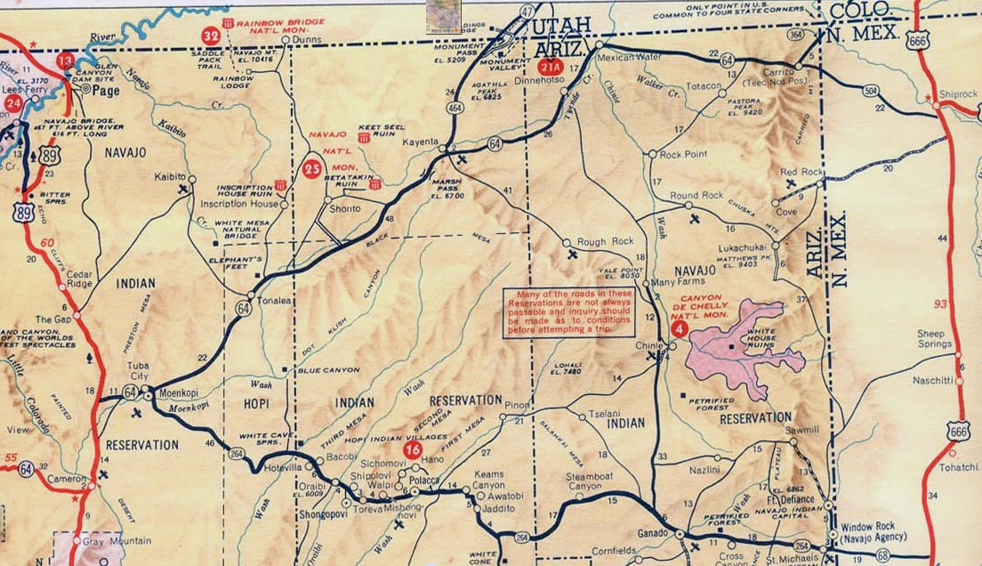
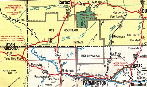
Between 1961-63, Arizona finished paving its segment of what is now mostly US 160 (from US 89 west of Tuba City to the NM state line east of Teec Nos Pos, where it connected with NM 504 to Shiprock).  This route was initially signposted as AZ 64 (the designation was extended eastward from Cameron).  A few other roads were also paved, and were numbered as branches of AZ 64.  AZ 264 began at Tuba City and headed east to New Mexico (as it still does).  AZ 364 went northeast from Teec Nos Pos (along modern US 160) to Four Corners.  The road heading north from Kayenta to Utah (which had just been paved a couple years earlier) was given the AZ 464 designation:
Picture
c. 1963, Arizona DoT
(Today's AZ 564 was not among these initial routes, but it was there by 1971.)  ​In 1965 the newly-paved highway between Tuba City and Towaoc (consisting of AZ 64, AZ 364, NM xxx, and CO 40) was unified when AASHO approved the US 164 route designation:
Picture
c. 1966, CDoT
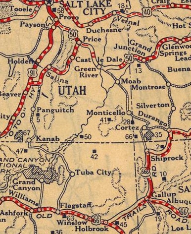
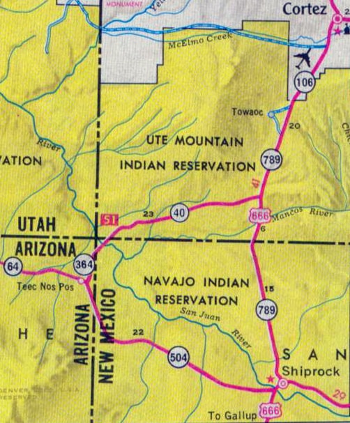
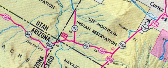
Offically, on its west end, US 164 overlapped with US 89 southward, ending in Flagstaff; and on its east end, it overlapped with US 666 northward, terminating in Cortez:
Picture
c. 1967, USGS
The refinement years
Arizona probably would have preferred the designation US 64 to replace what had been AZ 64, but at the time US 64 went only as far west as Santa Fe, and AASHO would not have allowed a separate segment of US 64.  Actually, the number 164 was not ideal either, since the route did not connect with US 64.  However, AASHO probably approved the number as a concession to Arizona.  At any rate, a new east-west US route running between US 66 and US 6-50 had been established, opening up access to what had previously been a very remote part of the Colorado Plateau.
Just a few years later (in Oct. 1969), AZ, CO, NM, and UT (or at least some of those states) proposed to AASHO that the US route designations in the Four Corners area should be shuffled thus:
  • Remove the US 160 designation from the Cortez-Monticello-Crescent corridor.  Instead, US 160 would follow Cortez-Towaoc-Teec Nos Pos-Kayenta-Tuba City, ending at US 89 and replacing all of the existing US 164.
  • The US 164 designation would instead be applied to a new corridor: it would follow AZ 464 north from Kayenta; U-47 northeast to Monticello; and the former US 160 north to Crescent Jct.  (This would have made US 164 even more of an anomaly: not only would it still not connect to US 64, but also the designation would be used for a north-south corridor, even though its number implied an east-west route.)
  • Extend the US 666 designation northward from Cortez along the former US 160, ending at Monticello.
In other words, a US route designation would be added to the Kayenta-Monticello corridor; all other existing US routes would remain on the system, although some segments would have new numbers.  But apparently not all four states agreed to this plan, because AASHO deferred a decision pending unanimous approval.  It is possible that applying the US 164 designation to a north-south corridor was one of the sticking points...

​...because, at the very next AASHO meeting (June 1970), the four states presented what was essentially the same plan, with one exception: the Kayenta-Monticello-Crescent corridor would be signposted as US 163 (instead of US 164).  In order to arrive at the odd number thought to be necessary for a north-south corridor, the previously-proposed number (164) was simply reduced by one integer.  At that time, someone should have stepped in and pointed out that the US 163 designation was no more appropriate than US 164, because that number implies a route branching off US 63.  But instead, AASHO approved the plan, and thus was born one of the worst numbering violations in the US route system:
Picture
c. 1977, Rand McNally
It is possible that the inappropriateness of the number 163 was considered, but in the absence of any more logical odd number, US 163 was deemed to be as good as any.  After all, the proposed route did not connect with any north-south US routes.  It had a junction with US 6-50 on the north, US 666 in the middle, and US 160 on the south.  So was a better numbering option even available?  One suggestion would have been to commission US 289, branching off from US 89 near Tuba City.  From there it would run through Kayenta and Monticello, ending at Crescent.  US 160 would end at its junction with US 289 in Kayenta, and US 666 could have been extended north to Monticello as planned.

The next year, Utah and Wyoming actually sought an extension of US 163 to the north, essentially along what is now US 191, ending at the south entrance to Yellowstone.  This would have eliminated the US 187 designation in Wyoming, but AASHO denied the proposal in both 1971 and 1972.
Also in 1972, the US 64 designation was eliminated from the Taos-Santa Fe segment, and instead extended westward to Farmington, where it ended at its junction with US 550.  From there, US 550 continued west to Shiprock, and then NM 504 covered the remaining distance to the state line:
Picture
c. 1973, Gousha
In Arizona, the former AZ 64 (which by then had probably been changed to AZ 504) was the road which continued west to Teec Nos Pos and the junction with US 160.  So at that time US 64 was only 54 miles away from reaching Teec Nos Pos.  (Note: it was 1973 when AASHO became AASHTO.)
In 1981 a major change was made to the US 191 designation: it was extended south through Wyoming and Utah, ending in Chambers AZ.*  The Utah segment of this extension included a 136-mile stretch along US 163 (from Crescent Jct. to Bluff).  Rather than dual-signing that segment, reportedly by 1985 Utah had removed all US 163 signs from it... although it was more than two decades before they formally asked AASHTO to decommission that part of US 163.  So, even though US 163 signage ended at Bluff, AASHTO records for the next 20+ years indicated that US 163 still continued all the way up to Crescent.  *(In 1992, US 191 was extended south from Chambers, replacing the former US 666 all the way to Douglas.  Then in 2003 the remainder of US 666 through NM, CO, and UT was replaced with the US 491 designation.  Both of these were good changes which improved route continuity, reduced sign theft, and replaced an even number on a north-south route with a more-appropriate odd number.)

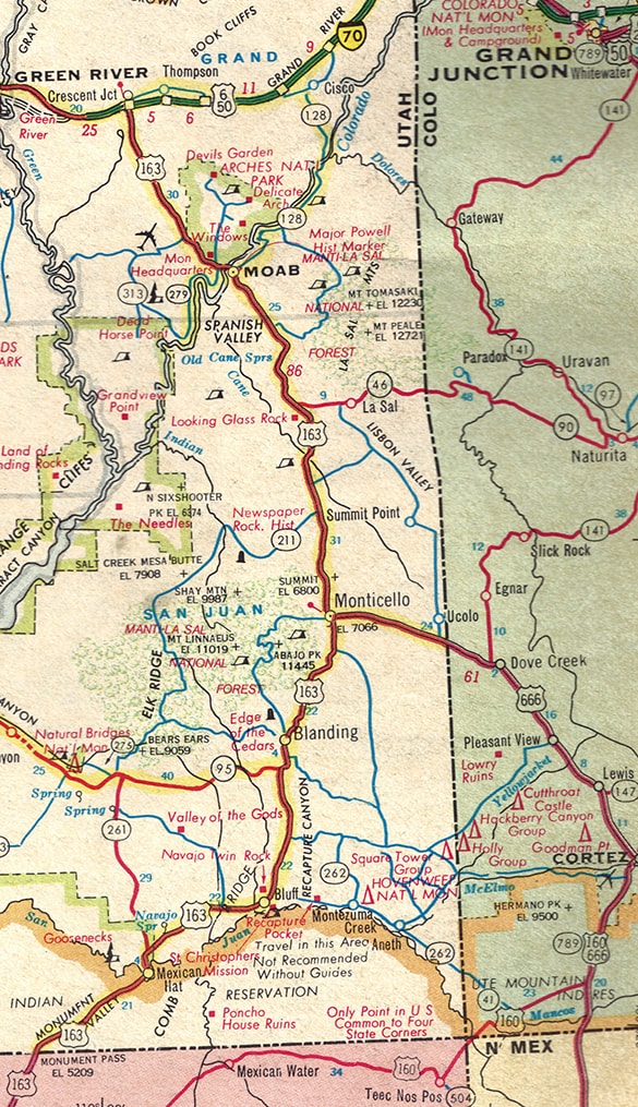
In 1989 the US 550 designation was truncated at Farmington*, and instead US 64 was extended west via former US 550.  But US 64 went 27 miles beyond US 550's historic terminus in Shiprock, ending at its junction with US 160 at Teec Nos Pos (the arrangement that still exists today).  *(In ​1998 New Mexico obtained approval to truncate the US 550 designation at Aztec, and instead extend it down to Bernalillo, which remains the current arrangement).  

Catching up to the present day  
Since the 1920s, several paved highways have been added in northern Arizona and southern Utah, greatly improving accessibility in the area.  During the development years, some route numbering decisions were made which later needed to be changed.  For example, the highway between Crescent Junction and Monticello has carried four different US route designations: US 450, US 160, US 163, and US 191.  Similarly, the Monticello-Cortez segment has been US 450, US 160, US 666, and US 491.  The result of these changes is that many of the early numbering problems have been fixed:
  • US 666 has been replaced by more appropriate numbers (US 191 and US 491).
  • Much of US 163 was replaced by US 191.
  • US 64 replaced some of US 550 and some state routes, improving east-west route continuity.
However, other numbering problems still exist in the Four Corners area, and these should be addressed.

Proposed changes to the US 64 and US 160 designations
It was a good move to unify the highway between Farmington and Teec Nos Pos under the US 64 designation.  Unfortunately, the proposal did not go far enough: the US 160 designation should have been truncated at Teec Nos Pos, and US 64 should have replaced it to the west.  Even if US 64 went only as far as Tuba City and ended at US 89 (where US 160 ends currently), it would create several positive improvements:
  • The arrangement at Teec Nos Pos is such that there is no stop sign for east-west traffic, so it is more logical for that movement to have a single route number.
  • Westbound US 160 traffic must stop, so that makes a logical point for that designation to end.
  • Something is not quite right when a long 2-digit US route (such as US 64) terminates at a mid-length 3-digit route (such as US 160).
  • As noted previously, the number "64" has an historical presence in the Four Corners area: the highway through northeast Arizona was originally designated AZ 64.
  • AZ highways 264 and 564 (originally numbered as branches off AZ 64) would make more sense in the context of US 64.
  • Having US 64 run through Kayenta would in turn allow US 163 to be renumbered to US 164, which would be a much more appropriate number for that route (more on that below).
But even better yet, an extended US 64 could continue south from Tuba City about 16 miles with US 89 to Cameron, and then west again on current AZ hwy. 64, replacing all of that designation and ending at I-40 outside Williams:
Picture
Additional benefits under that scenario:
  • It is fitting that a premier National Park like Grand Canyon should be served by a US route at both entrances.
  • Currently the terminus for US 180 is north of Tusayan.  It could remain that way, but then, at the point where US 180 quietly disappears at the south entrance to the Park, at least it would be dual-signed with US 64 (instead of AZ 64).  Otherwise US 180 could be truncated by about 23 miles, to Valle.  Then at least its terminus would be at a junction with a major cross-country route (US 64).

Proposed change to the US 163 designation
As noted previously: if the US 64 designation were to be extended through Kayenta, then that would set the stage to renumber US 163 as a branch route of US 64, specifically "US 164".  Benefits:
  • The Kayenta-Bluff highway would be designated with a number that makes sense within the context of the US route system.
  • US 164 was the number originally proposed for this route, back in 1969.

Summary
Over the decades, highway projects have gradually improved access to the Four Corners region of the Colorado Plateau.  Historically, the completion of these highways sometimes necessitated new US route designations and/or changes to existing designations.  That process is not quite complete: some of the US highway designations in the area still need to be changed.  This article highlights the specific segments that should be redesignated, and explains the rationale for the proposed changes.
4 Comments
Robert Dennis
5/1/2017 06:46:33 pm

Another scenario I have looked at for extending U.S. 64 is this: Run it along 89 and then 89A to Fredonia, AZ, then follow AZ 389, UT 59 and UT 9 to meet up with Interstate 15 in Hurricane. At least it will end at an interstate instead of quietly disappearing into a National Park Service road. Either way, I think it should be extended. At the very least, extend it past Teec Nos Pos. That is where U.S. 160 should end. I am in complete agreement with that.

Reply
Landry E. Heaton
5/11/2017 12:30:18 am

Totally agree; I've long advocated US 64 being extended along AZ 98, (US 89), (US 89A), AZ 389, UT 59, and UT 9 to I-15.

But I'm also OK with US 64 replacing US 160 to US 89 near Tuba City and down AZ 64 to I-40 at Williams with US 160 taking the northern route to I-15.

Reply
Bart Lee
11/2/2018 11:34:27 am

Perhaps fitting if US64 beginning East in Nags Head NC could end West near Edwards SFB CA.

Reply
Allen Widdows
12/7/2019 02:13:02 pm

At the very least, if US 64 is not extended, US 163 should be renumbered as either US 291 or US 391, using the same justification that created US 491 out of US 666. Another cool option for extending US 64 into Utah is to follow the suggested route up to Hurricane, but then follow UT-9 east toward Zion National Park, picking up again at the east entrance and ending at US 89 at Mt Carmel Jct. This is highly unlikely to happen, because of the loop back to the east, but Zion deserves access by a US highway.

Reply

Your comment will be posted after it is approved.


Leave a Reply.

    RSS Feed

    Author

    This guy.

    Categories

    All
    Arizona
    Boston
    California
    Colorado
    Denver
    Florida
    Geo-center
    Geography
    Historic
    Idaho
    Illinois
    Indiana
    Kansas
    Kentucky
    Maryland
    Massachusetts
    Michigan
    Midpoint
    Mileage
    Minnesota
    Missouri
    Nebraska
    New Hampshire
    New Jersey
    New Mexico
    Newport
    New York
    North Carolina
    North Dakota
    Numbering
    Oddity
    Ohio
    Oklahoma
    Oregon
    Pennsylvania
    Proposed
    Renumbering
    Signage
    South Carolina
    South Dakota
    Tennessee
    Texas
    Updates
    US 101
    US 127
    US 13
    US 136
    US 150
    US 154
    US 16
    US 160
    US 163
    US 164
    US 169
    US 177
    US 183
    US 190
    US 191
    US 20
    US 210
    US 212
    US 218
    US 220
    US 23
    US 24
    US 25
    US 259
    US 26
    US 266
    US 27
    US 270
    US 271
    US 277
    US 281
    US 283
    US 285
    US 287
    US 3
    US 31
    US 311
    US 321
    US 34
    US 36
    US 360
    US 371
    US 377
    US 383
    US 385
    US 40
    US 400
    US 411
    US 450
    US 46
    US 48
    US 491
    US 50
    US 530
    US 55
    US 59
    US 6
    US 60
    US 61
    US 62
    US 63
    US 65
    US 66
    US 666
    US 67
    US 730
    US 74
    US 77
    US 81
    US 83
    US 84
    US 85
    US 87
    US 89
    US 93
    US 94
    US 96
    US 99
    Utah
    Virginia
    Washington
    Watersheds
    West Virginia
    Wyoming

    Archives

    August 2022
    March 2022
    February 2022
    January 2022
    August 2021
    July 2021
    June 2021
    April 2021
    February 2021
    January 2021
    August 2020
    July 2020
    May 2020
    April 2020
    March 2020
    February 2020
    January 2020
    December 2019
    October 2019
    September 2019
    August 2019
    May 2019
    January 2019
    November 2018
    June 2018
    April 2018
    March 2018
    November 2017
    September 2017
    August 2017
    June 2017
    March 2017
    February 2017
    January 2017
    December 2016

Copyright © 1998-2023
Picture