US Ends .com
  • Home
  • Store
    • US highway map
    • Florida US highway map
  • Endpoints
    • US 1 - US 9 >
      • 1 >
        • 201
        • 301
        • 401 [i]
        • 401 [ii]
        • 401
        • 501
        • 601
        • 701
      • 2w >
        • 102
      • 2e >
        • 202
        • 302
      • 3
      • 4 >
        • 104
      • 5
      • 6 >
        • 106
        • 206
      • 7
      • 8
      • 9 >
        • 109*
        • 209
        • 309
    • US 10 - US 19 >
      • 10 >
        • 110
        • 210
        • 310
        • 410
      • 11 >
        • 111
        • 211
        • 311
        • 411 [i]
        • 411 [ii]
        • 411
        • 511*
        • 611
        • 711*
      • 12 >
        • 112
        • 212
        • 312
      • 13 >
        • 113
        • 213
      • 14
      • 15
      • 16 >
        • 116
        • 216
      • 17 >
        • 17-1
        • 117 [i]
        • 117
        • 217
      • 18 >
        • 118
        • 218
      • 19 >
        • 119
        • 219
        • 319
    • US 20 - US 29 >
      • 20e >
        • 120
        • 220
        • 320
        • 420
      • 20w
      • 21 >
        • 121 [i]
        • 121
        • 221
        • 321
        • 421
        • 521
      • 22 >
        • 122 [i]
        • 122 [ii]
        • 222
        • 322
        • 422e
        • 422w
        • 522
        • 622*
      • 23 >
        • 123 [i]
        • 123
        • 223
      • 24 >
        • 124
        • 224
      • 25
      • 26 >
        • 126
      • 27 >
        • 127
        • 227
      • 28
      • 29 >
        • 129
    • US 30 - US 39 >
      • 30 >
        • 130
        • 230
        • 330
        • 430
        • 530
        • 630*
        • 730
        • 830
      • 31 >
        • 131
        • 231
        • 331 [i]
        • 331
        • 431
      • 32
      • 33
      • 34
      • 35
      • 36 >
        • 136
      • 38 >
        • 138
    • US 40 - US 49 >
      • 40 >
        • 140
        • 240
        • 340
      • 41 >
        • 141
        • 241 [i]
        • 241 [ii]
        • 341
        • 441 >
          • 441n
          • 441s
        • 541
        • 641
      • 42
      • 43
      • 44
      • 45
      • 46
      • 48 [i]
      • 48 [ii]
      • 48
      • 49
    • US 50 - US 59 >
      • 50 >
        • 150
        • 250
        • 350
        • 450
        • 550
        • 650
      • 51 - 55 >
        • 51 >
          • 151
        • 52 >
          • 152
        • 53
        • 54 >
          • 154
        • 55
      • 56 >
        • 156
      • 57
      • 58 >
        • 158
        • 258
      • 59 >
        • 159
        • 259
    • US 60 - US 69 >
      • 60 >
        • 160
        • 260
        • 360
        • 460
      • 61 - 65 >
        • 61 >
          • 161
        • 62
        • 63 >
          • 163 [i]
        • 64 >
          • 164 [i]
          • 164 [ii]
          • 264
        • 65 >
          • 165
      • 66 >
        • 166
        • 266
        • 366 [i]
        • 366 [ii]
        • 466
        • 566
        • 666
      • 67 >
        • 167
      • 68 >
        • 168
      • 69 >
        • 169
    • US 70 - US 79 >
      • 70 >
        • 170
        • 270 [i]*
        • 270
        • 370
        • 470
      • 71 >
        • 171
        • 271
        • 371 [i]
        • 371
      • 72 - 76 >
        • 72
        • 73
        • 74
        • 75 >
          • 175
          • 275
        • 76 >
          • 176
          • 276
      • 77 >
        • 177
        • 277
        • 377
      • 78 >
        • 178
        • 278
        • 378
      • 79
    • US 80 - US 89 >
      • 80 - 84 >
        • 80 >
          • 180 [i]
          • 180
          • 280
          • 380
        • 81 >
          • 181
          • 281
        • 82
        • 83 >
          • 183
          • 283
          • 383
        • 84
      • 85 - 89 >
        • 85 >
          • 185
          • 285 [i]
          • 285
          • 385 [i]
          • 385
          • 485
        • 87 >
          • 187
          • 287n
          • 287s
        • 89n
        • 89s >
          • 189 [i]
          • 189
    • US 90 - US 99 >
      • 90 - 94 >
        • 90 >
          • 190
          • 290
        • 91 >
          • 191 >
            • 191n
            • 191s
          • 491
        • 92 >
          • 192
        • 93
        • 94
      • 95 -98 >
        • 95 >
          • 195
          • 295
          • 395
        • 96 [i]
        • 96
        • 97 >
          • 197
        • 98
      • 99 >
        • 199
        • 299
        • 399
    • Anomalies >
      • 101
      • 163
      • 400
      • 412
      • 425
  • Places
    • A-L >
      • A >
        • Aberdeen
        • Albuquerque
        • Amarillo
        • Apalachicola
        • Astoria
        • Atlantic
      • B >
        • Baltimore
        • Baton Rouge
        • Bay Area
        • Bishop
        • Boone
        • Brady
        • Bristol
        • Brownsville
        • Brunswick
      • C >
        • Charleston
        • Chattanooga
        • Chicago
        • Cincinnati
        • Cleveland
        • Cody
        • Corpus
        • Cortez
        • Council Bluffs
        • Covington
        • Crescent
        • Cumberland Gap
      • D-E >
        • Dallas
        • Des Moines
        • Detroit
        • Dothan
        • Douglas
        • El Paso
        • Eugene
        • Erie
      • F >
        • Farmington
        • Flagstaff
        • Florence
        • Fox Valley
        • Franklin
      • G >
        • Gallup
        • Georgetown
        • Grand Junction
        • Grand Portage
        • Grayling
        • Great Falls
        • Greeley
      • H-I >
        • Hardeeville
        • Harrisburg
        • Holbrook
        • Idaho Falls
        • Int'l Falls
      • J-K >
        • Jacksonville
        • Joplin
        • Junction
        • Kansas City
        • Keokuk
        • Key West
        • Kingman
      • L >
        • Laredo
        • Lewiston
        • Long Beach
        • Los Angeles
        • Louisville
        • Lubbock
    • M-R >
      • M >
        • Mackinaw
        • Madison
        • Maryhill
        • Maysville
        • Miami
        • Midway
        • Miles City
        • Milford
        • Milwaukee
        • Minneapolis
        • Mobile 31
        • Mobile 31-43-45
        • Montgomery
        • Monticello
        • Mount Vernon
      • N-O >
        • Nags Head
        • Naples
        • Natchez
        • New Castle
        • New Orleans
        • Niagara
        • Norlina
        • Ocean City
        • Oklahoma City
      • P >
        • Pee Dee
        • Pembina
        • Pensacola
        • Petersburg
        • Philadelphia
        • Piegan
        • Pineville
        • Port Arthur
        • Portsmouth
      • Q-R >
        • Quad Cities
        • Rapid City
        • Raton
        • Reading
        • Richmond
        • Rockingham
        • Rouses Point
    • S-Z >
      • S >
        • San Antonio
        • San Antonio NM
        • San Diego
        • Santa Fe
        • Savannah
        • Sioux
        • Springer
        • Springfield
        • St. Ignace
        • St. John
        • St. Paul
        • St. Pete
      • T-U-V >
        • Tallahassee
        • Tampa
        • Toledo
        • Trinidad
        • Ucolo
        • VA Beach
      • W >
        • Walterboro
        • Waverly
        • West Memphis
        • Wilmington
        • Wilson
        • Wrightsville
      • Y >
        • Yellowstone E
        • Yellowstone N
        • Yellowstone NE
        • Yellowstone S
        • Yellowstone W
  • Highways
    • Map of all endpoints
    • Sources
    • History
    • 1926 almost-routes
    • Intra-state routes
    • Numbering
    • Colors
    • Gaps
    • Blog
  • Bonus
    • Colorado >
      • Lowest point
      • Antipodes
      • Toponymy >
        • Roots
      • Colloquialisms
      • Populations
      • Denvers
    • Washington Meridian
    • Watersheds >
      • Headwaters Hill
      • Three Waters Mtn.
      • Parting of the Waters
    • Geo-centers >
      • 48 states
      • 50 states
      • North America
    • State corners >
      • AZ-CO-NM-UT
      • CO-UT-WY
      • CO-NE-WY
      • CO northeast
      • CO-KS-NE
      • CO-KS-OK
      • CO-NM-OK
      • NM-OK-TX
      • NM southeast
      • TX northwest
    • ooss.space
  • Connect
    • Author/history
    • Rationale
    • Contact
    • Contributors
    • Submissions

US Highways Blog

Traces of history in the Virginia Village area

5/25/2023

0 Comments

 
(last updated 6/19/2023)
​Do you ever think about what was here, before you were here?  Before we all were here, with all of our roads, neighborhoods, houses, parks, buildings?


We could go way back, millions of years, when the area that would later be known as "Denver" was still submerged beneath the western edge of a vast interior sea.

​Or we could go back not quite as far, maybe just 200 or 300 years, to a time when the only humans living in this area were those who belonged to the local Native American tribes.  As they went in search of game, or moved their camps from one place to another, they formed trails, particularly along the streams in the area.


​Settlers of European descent did not begin to arrive here in earnest until the 1850s, less than 200 years ago.  The old Native American trail along the east bank of Cherry Creek started to be used by new groups of people, who referred to it as the Cherokee Trail, the Goodnight-Loving cattle trail, or the Denver-Santa Fe stage line.
But for this article, I am focusing on a time even more recent, less than 100 years ago.  During the 1940s, there was no "Cook Park", nor a "Virginia Village", nor were there any other developed neighborhoods.  At the time, the area south of Alameda Av. and east of Colorado Blvd. had not yet been annexed into the City and County of Denver, so what is now Virginia Village was still a part of unincorporated Arapahoe County.  This snapshot-in-time was illustrated on the 1940 and 1944 editions of the USGS topographical map covering the "Englewood" quadrangle.  Here is a small section of that map, showing the intersection of Holly and Jewell, and centered on the area that would later be developed as the Lynwood subdivision:
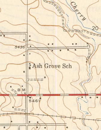
Picture
c. 1944, USGS
As you can see, there was so little development at the time that the dominant visual feature on the map was not the roads, but rather the elevation contour lines.  Compare that to a more recent version of the USGS map which covers the same exact geography:
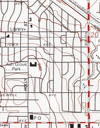
Picture
c. 1999, USGS
I set out to visualize the level of development in the Virginia Village area during the 1940s, so to make it more clear, I digitally traced the 1940 USGS map, including all features except for the topo lines (below).  Roads are shown in black/gray; water features in blue; and houses/buildings in red:
Picture
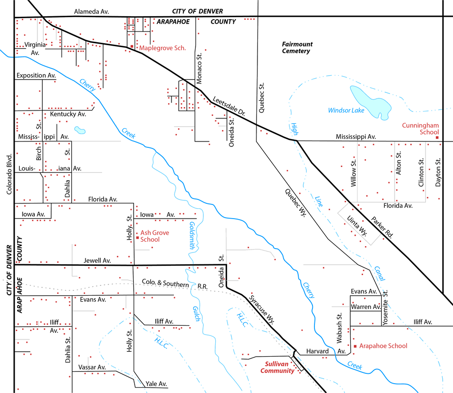
I also added the road names, although it should be noted that these are the modern road names (it is likely that some of these roads had different names when they were built and/or before they had been changed to align with the names on the greater Denver street grid).  It might be hard to believe, but that is not a generalized map; rather that map shows all of the roads and all of the houses/buildings that existed in this area during the 1940s.  As you can see, Virginia Village and surrounding areas were much less densely-populated.  At the time, Denverites would have considered this area to be "out in the country".
Growth and development really ramped up in the Denver area during the 1950s, and obviously a lot has changed since then in the Virginia Village area.  But are there any surviving vestiges from the time period shown on the map above, prior to the post-war growth years?  Indeed, there are, as we will see below.

Goldsmith Gulch

At the time of the map above, Monaco Parkway had not yet been extended south of Cherry Creek.  Running right about where Monaco would later be built was Goldsmith Gulch, which still followed its natural meandering course.  In order to build Monaco, it was first necessary to corral the northward-flowing stream into a rigid concrete channel.  So the Goldsmith Gulch that we see today rises to the east of Monaco, then briefly crosses west of Monaco (from Evans through Skyline Acres), then back to the east side of Monaco, where it remains as it continues through Cook Park and discharges into Cherry Creek.  But it was not always that way.

Prior to development, roughly between modern-day Iowa and Florida Avenues, Goldsmith Gulch originally crossed back over to the west side of what would later become Monaco.  From there it flowed northwesterly, roughly along today's Minnesota Drive.  Its confluence with Cherry Creek was north of today's intersection of Minnesota and Honey Way.  

Cherry Creek itself has since been channelized as well, but despite all that wrangling of nature, there is still an original segment of Goldsmith Gulch that is mostly undisturbed.  The site is accessible from the Cherry Creek recreational trail, between Monaco and Holly.  Along that segment, Cherry Creek flows over two rock drop structures (sort of like waterfalls, but man-made).  Approximately midway between those two drop structures, just off the north edge of the trail, you can view this scene:
NB_storm-sewer_channel
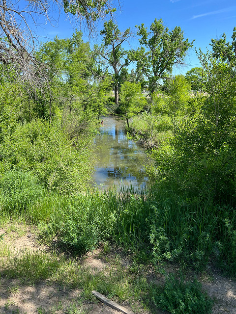
There, we are looking northward along a channel that empties into Cherry Creek (which is visible in the middle ground, flowing from right to left).  This straight channel was man-made; it is simply the outlet for the large storm sewer that drains from the intersection Minnesota and Honey Way.   So that is not the original Goldsmith Gulch, but if you take a few steps to the left (west), you will see this:
NB_old-goldsmith-channel
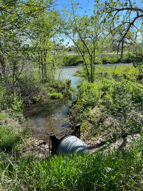
That too is looking northward, this time along the original channel of Goldsmith Gulch (minus the modern-day culvert, of course, which allows water to flow under the recreational trail).  The old stream bed curves to the right and then joins the straight channel that we saw in the previous photo.  Cherry Creek is visible in the middle ground, although that is not the location of the original confluence, because historically Cherry Creek ran farther to the north.  In fact, Lollipop Lake in Garland Park sits in a depression that was originally the stream bed of Cherry Creek.  That is illustrated on the map below, which was created by taking a small section of the map above and underlaying it with a modern basemap, in order to see where the streams originally ran:
Picture
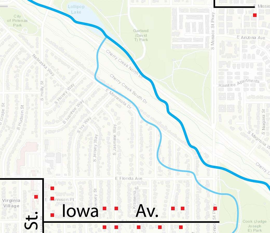
That suggests that the original mouth of Goldsmith Gulch has long since been submerged under Lollipop Lake.  That map also illustrates that much of the neighborhood between Monaco and Holly and north of Florida Avenue could not have been developed if Goldsmith Gulch had not been redirected to remain on the east side of Monaco.  None of the houses on Locust, Leyden, or Krameria could have been built, and the only part of Minnesota that could have existed was the segment between Holly and Honey Way.

Colorado and Southern Railway

This was probably the first modern transportation development in what would eventually become the Virginia Village area.  The tracks were laid in 1881, but already by 1935 the railroad was no longer in use to the east of Holly St.  For that reason, I would say the railroad did not really contribute to the growth of southeast Denver, since the vast majority of that happened after 1935.  However, the railroad company continued to own the right-of-way for a few more decades, and to the west of Holly it continued to function as a working railroad until the 1970s.  So as Denver grew and newer developments began to abut the old tracks, city planners had to figure out ways to work around the railroad.  To this day, along the three-mile stretch between University Blvd and Oneida Street, there are relatively few north-south roads that cross the old railroad's former right-of-way.  I have written more about vestiges of the old Colorado and Southern Railway on this blog post.

The old Harvard Avenue bridge

Today, between Colorado Blvd and Hampden/Havana, there are six vehicular bridges over Cherry Creek, plus 12 recreational bridges.  But during the 1940s there was only one bridge along that stretch, and you might be surprised where it was located: Harvard Avenue (shown at lower right on the map above).  Why did Harvard have a bridge over Cherry Creek?  Well, for one thing, neither Iliff nor Yale had a bridge at the time.  But still, why Harvard?  It was undoubtedly related to a small community known as Sullivan (or Oakes) which was situated along Harvard where it crossed both the High Line Canal and the C&S Railroad.  The Sullivan post office was established in 1890, so it had been around for awhile (incidentally, today's post office at 8700 E. Jefferson was named after the original Sullivan PO).  Sullivan was located just to the west of Cherry Creek, and the Harvard bridge may have been built to connect the community with the school that was located on the east side of the creek (this was in the same location as today's Denver Jewish Day School).  The first Iliff bridge was built in the 1950s, about two blocks north of the Harvard bridge, and that was right about the same time that the Harvard bridge was dismantled.  

But a small trace of the old Harvard bridge still exists today.  Here is how to find it: on the north landing of the Yale/Wabash bridge over Cherry Creek, there is a small parking lot for the Wabash trailhead.  Just to the west of there some power lines go over the Cherry Creek Trail.  Those power lines mark the alignment of old Harvard Av.  Underneath those power lines, just off the west edge of the Cherry Creek Trail, you can see the old earthen bridge abutment for Harvard Av.  And if you walk upon it, you will see that some of the old asphalt surface still exists (that is often a little easier to do during the colder months, when there is not as much wild vegetation).  The photo below was taken looking west on the old Harvard bridge; some of the old asphalt is visible here:
Old Harvard Avenue Bridge
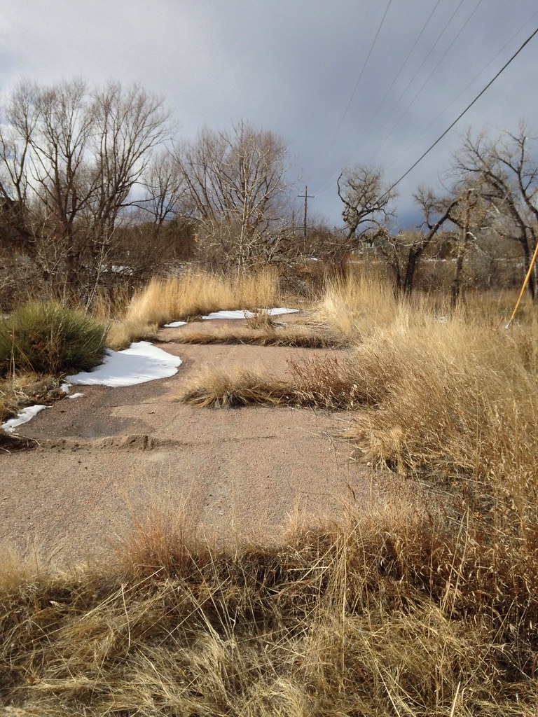
Straight ahead, on the far side (west side) of Cherry Creek is a still-extant segment of Harvard.  About a quarter-mile in that direction, Harvard crosses the High Line Canal and passes the site of historic Sullivan.

Older houses

Obviously there's the Four Mile House, which is the oldest surviving building in the Denver area, dating back to 1859.  But in addition to that, the map above shows a red dot at the location of each house that existed prior to the 1950s.  Some of those houses still exist.  For example, if you were to make your way along Iowa Avenue between Holly and Monaco, you would see a few surviving older houses on both sides of the street.  Those existed prior to the subdivisions that were later developed both to the north and south of Iowa.  And in fact, those older houses explain why several of the north-south streets that intersect Iowa are offset from each other: the developers had to work around some pre-existing property boundaries.

You can use the map above to identify other roads and houses that existed in southeast Denver prior to the 1950s, and see for yourself whether any of the original houses are still standing.

If you have any memories of what the Virginia Village area was like before it was developed, or if you are aware of other historic vestiges that still exist in this area, we would love to hear from you in the comment section, below.
0 Comments

Your comment will be posted after it is approved.


Leave a Reply.

    RSS Feed

    Author

    This guy.

    Categories

    All
    Arizona
    Boston
    California
    Colorado
    Denver
    Florida
    Geo-center
    Geography
    Historic
    Idaho
    Illinois
    Indiana
    Kansas
    Kentucky
    Maryland
    Massachusetts
    Michigan
    Midpoint
    Mileage
    Minnesota
    Missouri
    Nebraska
    New Hampshire
    New Jersey
    New Mexico
    Newport
    New York
    North Carolina
    North Dakota
    Numbering
    Oddity
    Ohio
    Oklahoma
    Oregon
    Pennsylvania
    Proposed
    Renumbering
    Signage
    South Carolina
    South Dakota
    Tennessee
    Texas
    Updates
    US 101
    US 127
    US 13
    US 136
    US 150
    US 154
    US 16
    US 160
    US 163
    US 164
    US 169
    US 177
    US 180
    US 183
    US 190
    US 191
    US 20
    US 210
    US 212
    US 218
    US 220
    US 23
    US 24
    US 25
    US 259
    US 26
    US 266
    US 27
    US 270
    US 271
    US 277
    US 281
    US 283
    US 285
    US 287
    US 3
    US 31
    US 311
    US 321
    US 34
    US 36
    US 360
    US 371
    US 377
    US 383
    US 385
    US 40
    US 400
    US 411
    US 450
    US 46
    US 48
    US 491
    US 50
    US 530
    US 55
    US 59
    US 6
    US 60
    US 61
    US 62
    US 63
    US 65
    US 66
    US 666
    US 67
    US 730
    US 74
    US 77
    US 80
    US 81
    US 83
    US 84
    US 85
    US 87
    US 89
    US 93
    US 94
    US 96
    US 99
    Utah
    Virginia
    Washington
    Watersheds
    West Virginia
    Wyoming

    Archives

    August 2023
    May 2023
    March 2023
    February 2023
    January 2023
    August 2022
    March 2022
    February 2022
    January 2022
    August 2021
    July 2021
    June 2021
    April 2021
    February 2021
    January 2021
    August 2020
    July 2020
    May 2020
    April 2020
    March 2020
    February 2020
    January 2020
    December 2019
    October 2019
    September 2019
    August 2019
    May 2019
    January 2019
    November 2018
    June 2018
    April 2018
    March 2018
    November 2017
    September 2017
    August 2017
    June 2017
    March 2017
    February 2017
    January 2017
    December 2016

Copyright © 1998-2023
Picture