US Ends .com
  • Home
  • Store
    • US highway map
    • Florida US highway map
  • Endpoints
    • US 1 - US 9 >
      • 1 >
        • 201
        • 301
        • 401 [i]
        • 401 [ii]
        • 401
        • 501
        • 601
        • 701
      • 2w >
        • 102
      • 2e >
        • 202
        • 302
      • 3
      • 4 >
        • 104
      • 5
      • 6 >
        • 106
        • 206
      • 7
      • 8
      • 9 >
        • 109*
        • 209
        • 309
    • US 10 - US 19 >
      • 10 >
        • 110
        • 210
        • 310
        • 410
      • 11 >
        • 111
        • 211
        • 311
        • 411 [i]
        • 411 [ii]
        • 411
        • 511*
        • 611
        • 711*
      • 12 >
        • 112
        • 212
        • 312
      • 13 >
        • 113
        • 213
      • 14
      • 15
      • 16 >
        • 116
        • 216
      • 17 >
        • 17-1
        • 117 [i]
        • 117
        • 217
      • 18 >
        • 118
        • 218
      • 19 >
        • 119
        • 219
        • 319
    • US 20 - US 29 >
      • 20e >
        • 120
        • 220
        • 320
        • 420
      • 20w
      • 21 >
        • 121 [i]
        • 121
        • 221
        • 321
        • 421
        • 521
      • 22 >
        • 122 [i]
        • 122 [ii]
        • 222
        • 322
        • 422e
        • 422w
        • 522
        • 622*
      • 23 >
        • 123 [i]
        • 123
        • 223
      • 24 >
        • 124
        • 224
      • 25
      • 26 >
        • 126
      • 27 >
        • 127
        • 227
      • 28
      • 29 >
        • 129
    • US 30 - US 39 >
      • 30 >
        • 130
        • 230
        • 330
        • 430
        • 530
        • 630*
        • 730
        • 830
      • 31 >
        • 131
        • 231
        • 331 [i]
        • 331
        • 431
      • 32
      • 33
      • 34
      • 35
      • 36 >
        • 136
      • 38 >
        • 138
    • US 40 - US 49 >
      • 40 >
        • 140
        • 240
        • 340
      • 41 >
        • 141
        • 241 [i]
        • 241 [ii]
        • 341
        • 441 >
          • 441n
          • 441s
        • 541
        • 641
      • 42
      • 43
      • 44
      • 45
      • 46
      • 48 [i]
      • 48 [ii]
      • 48
      • 49
    • US 50 - US 59 >
      • 50 >
        • 150
        • 250
        • 350
        • 450
        • 550
        • 650
      • 51 - 55 >
        • 51 >
          • 151
        • 52 >
          • 152
        • 53
        • 54 >
          • 154
        • 55
      • 56 >
        • 156
      • 57
      • 58 >
        • 158
        • 258
      • 59 >
        • 159
        • 259
    • US 60 - US 69 >
      • 60 >
        • 160
        • 260
        • 360
        • 460
      • 61 - 65 >
        • 61 >
          • 161
        • 62
        • 63 >
          • 163 [i]
        • 64 >
          • 164 [i]
          • 164 [ii]
          • 264
        • 65 >
          • 165
      • 66 >
        • 166
        • 266
        • 366 [i]
        • 366 [ii]
        • 466
        • 566
        • 666
      • 67 >
        • 167
      • 68 >
        • 168
      • 69 >
        • 169
    • US 70 - US 79 >
      • 70 >
        • 170
        • 270 [i]*
        • 270
        • 370
        • 470
      • 71 >
        • 171
        • 271
        • 371 [i]
        • 371
      • 72 - 76 >
        • 72
        • 73
        • 74
        • 75 >
          • 175
          • 275
        • 76 >
          • 176
          • 276
      • 77 >
        • 177
        • 277
        • 377
      • 78 >
        • 178
        • 278
        • 378
      • 79
    • US 80 - US 89 >
      • 80 - 84 >
        • 80 >
          • 180 [i]
          • 180
          • 280
          • 380
        • 81 >
          • 181
          • 281
        • 82
        • 83 >
          • 183
          • 283
          • 383
        • 84
      • 85 - 89 >
        • 85 >
          • 185
          • 285 [i]
          • 285
          • 385 [i]
          • 385
          • 485
        • 87 >
          • 187
          • 287n
          • 287s
        • 89n
        • 89s >
          • 189 [i]
          • 189
    • US 90 - US 99 >
      • 90 - 94 >
        • 90 >
          • 190
          • 290
        • 91 >
          • 191 >
            • 191n
            • 191s
          • 491
        • 92 >
          • 192
        • 93
        • 94
      • 95 -98 >
        • 95 >
          • 195
          • 295
          • 395
        • 96 [i]
        • 96
        • 97 >
          • 197
        • 98
      • 99 >
        • 199
        • 299
        • 399
    • Anomalies >
      • 101
      • 163
      • 400
      • 412
      • 425
  • Places
    • A-L >
      • A >
        • Aberdeen
        • Albuquerque
        • Amarillo
        • Apalachicola
        • Astoria
        • Atlantic
      • B >
        • Baltimore
        • Baton Rouge
        • Bay Area
        • Bishop
        • Boone
        • Brady
        • Bristol
        • Brownsville
        • Brunswick
      • C >
        • Charleston
        • Chattanooga
        • Chicago
        • Cincinnati
        • Cleveland
        • Cody
        • Corpus
        • Cortez
        • Council Bluffs
        • Covington
        • Crescent
        • Cumberland Gap
      • D-E >
        • Dallas
        • Des Moines
        • Detroit
        • Dothan
        • Douglas
        • El Paso
        • Eugene
        • Erie
      • F >
        • Farmington
        • Flagstaff
        • Florence
        • Fox Valley
        • Franklin
      • G >
        • Gallup
        • Georgetown
        • Grand Junction
        • Grand Portage
        • Grayling
        • Great Falls
        • Greeley
      • H-I >
        • Hardeeville
        • Harrisburg
        • Holbrook
        • Idaho Falls
        • Int'l Falls
      • J-K >
        • Jacksonville
        • Joplin
        • Junction
        • Kansas City
        • Keokuk
        • Key West
        • Kingman
      • L >
        • Laredo
        • Lewiston
        • Long Beach
        • Los Angeles
        • Louisville
        • Lubbock
    • M-R >
      • M >
        • Mackinaw
        • Madison
        • Maryhill
        • Maysville
        • Miami
        • Midway
        • Miles City
        • Milford
        • Milwaukee
        • Minneapolis
        • Mobile 31
        • Mobile 31-43-45
        • Montgomery
        • Monticello
        • Mount Vernon
      • N-O >
        • Nags Head
        • Naples
        • Natchez
        • New Castle
        • New Orleans
        • Niagara
        • Norlina
        • Ocean City
        • Oklahoma City
      • P >
        • Pee Dee
        • Pembina
        • Pensacola
        • Petersburg
        • Philadelphia
        • Piegan
        • Pineville
        • Port Arthur
        • Portsmouth
      • Q-R >
        • Quad Cities
        • Rapid City
        • Raton
        • Reading
        • Richmond
        • Rockingham
        • Rouses Point
    • S-Z >
      • S >
        • San Antonio
        • San Antonio NM
        • San Diego
        • Santa Fe
        • Savannah
        • Sioux
        • Springer
        • Springfield
        • St. Ignace
        • St. John
        • St. Paul
        • St. Pete
      • T-U-V >
        • Tallahassee
        • Tampa
        • Toledo
        • Trinidad
        • Ucolo
        • VA Beach
      • W >
        • Walterboro
        • Waverly
        • West Memphis
        • Wilmington
        • Wilson
        • Wrightsville
      • Y >
        • Yellowstone E
        • Yellowstone N
        • Yellowstone NE
        • Yellowstone S
        • Yellowstone W
  • Highways
    • Map of all endpoints
    • Sources
    • History
    • 1926 almost-routes
    • Intra-state routes
    • Numbering
    • Colors
    • Gaps
    • Blog
  • Bonus
    • Colorado >
      • Lowest point
      • Antipodes
      • Toponymy >
        • Roots
      • Colloquialisms
      • Populations
      • Denvers
    • Washington Meridian
    • Watersheds >
      • Headwaters Hill
      • Three Waters Mtn.
      • Parting of the Waters
    • Geo-centers >
      • 48 states
      • 50 states
      • North America
    • State corners >
      • AZ-CO-NM-UT
      • CO-UT-WY
      • CO-NE-WY
      • CO northeast
      • CO-KS-NE
      • CO-KS-OK
      • CO-NM-OK
      • NM-OK-TX
      • NM southeast
      • TX northwest
    • ooss.space
  • Connect
    • Author/history
    • Rationale
    • Contact
    • Contributors
    • Submissions

US Highways Blog

Colorado's original North Front Range highway

2/21/2022

2 Comments

 
Prior to I-25, there was a different main highway that connected Denver to several of the Northern Front Range cities in Colorado.  The number of this highway has changed a few times during the past century, but its general corridor has remained the same: it still runs through Ft. Collins, Loveland, Berthoud, Longmont, Lafayette, Broomfield, Westminster, and Denver.  Not all of those cities had even been established at the time of the 1916 map shown below, but the highway corridor running along the Northern Front Range is readily apparent (going forward I will refer to this road as the NFRH, for "North Front Range Highway"):

Read More
2 Comments

Addressing some map-related misconceptions

2/1/2022

0 Comments

 
Our planet is spheroidal in shape, which means its surface is curved.  So making a map of the Earth's surface involves taking something that is curved and projecting it onto something flat (such as a piece of paper or a computer screen).  But this flattening inherently causes some distortion from reality.  It is not possible for any one map projection to preserve all of the following: 1.) direction, 2.) shape, 3.) area, and 4.) distance.  So when a cartographer chooses a particular map projection, they are choosing to preserve one or more of those traits at the expense of others.

Read More
0 Comments

All about the shortest US routes

1/7/2022

2 Comments

 
(last updated 8/5/2022)
​Lots of people (myself included) have an odd fascination with the superlatives of just about any topic.  As it relates to highways, a common question is "What is the longest US route?"  (answer)  And then related questions branch off from there:
  • What was the longest US route historically?  (answer)
  • What is the longest north-south US route?  (answer)
  • What is the longest 3-digit US route?  (answer)
  • What is the longest 3-digit US route that runs east-west?  (answer)
Eventually the questions start swinging around to the opposite extreme, and those are the topics of this post.  Specifically we set out to answer these questions:
  • What is the shortest US route?
  • What was the shortest US route historically?
  • What is the shortest 2-digit US route?
  • What was the shortest 2-digit US route historically?

Read More
2 Comments

Midpoint of historic US 99 in California

8/29/2021

0 Comments

 
Currently the longest single-state mileage of any US route is 893 miles (US 83 in Texas).  Historically, before US 101 was truncated to Los Angeles, that route was undoubtedly the record-holder: the California segment of US 101 was about 941 miles (give or take a few, depending on which year, since the alignment changed many times and in many places). 

Historic US 99 in California was the second-longest route through a single state, although its mileage is even more difficult to measure, since it was replaced by I-5 in many areas, and as a result some segments of the original route have been vacated.  The Historic Highway 99 Association of California offers a length of 917 miles.  Although that page does not specify a year, I am sure that figure is reliable, since my own back-of-the-envelope calculation yielded a similar distance.  (Note that drivers choosing US 99E between Sacramento and Red Bluff had to travel 2.2 miles further than those who chose US 99W.)

Thanks to this blog post, I recently became aware of "the Palm and the Pine" along what is now CA state hwy. 99, just southeast of Madera.  In the median of the highway, a palm tree and a pine tree are planted side by side (one representing southern California, and the other representing northern California):

Read More
0 Comments

Recent changes and updates

8/13/2021

0 Comments

 
US 96, US 14, US 75, US 99, US 240, US 42, US 138, US 360, US 431, US 380, San Antonio NM, Astoria, US 650, US 28, US 113, Crescent Jct, San Angelo, Long Beach, US 270, US 412, US 277, Springer, Trinidad, US 41, US 99, US 130, US 209, Toledo, Cleveland, Cumberland Gap, Cincinnati, US 91, US 75, US 175, US 80, Louisville, US 601, US 167, US 111, US 97 ​
0 Comments

Misleading highway signage in Denver

8/7/2021

4 Comments

 
The other day I was driving north on C-470, and I wanted to go east on the 6th Avenue Freeway towards downtown Denver.  That movement is shown on the map below:
I rarely drive that direction along C-470, but I have lived in Denver for a long time, and I'm pretty confident about knowing my way around.  So as I approached, I was quite certain that I would need to follow eastbound I-70, and that the exit for eastbound US 6 would come up shortly after that. 

​But then I saw this: the first sign that references US 6 on northbound C-470:

Read More
4 Comments

Geeking out at the Peace Arch

7/21/2021

3 Comments

 
The focal point of Blaine, Washington, is the Peace Arch international park and border crossing.  Lots of interesting things to see there, including the north terminus of I-5 and the north terminus of historic US 99. 
Get your very own map showing all current and historic US routes!
The photo below was taken looking east along the international boundary between Canada (to the left) and the U.S. (right).  The large structure (with the flags on top) is the Peace Arch, which straddles the border.  (It is not square to the boundary line; rather it is situated at a slight diagonal that roughly matches the angle of the roads that run through here.)  If you look closely, you can see three boundary obelisks in the foreground:

Read More
3 Comments

Why US 285 should be signed east-west in the Denver area

6/25/2021

5 Comments

 
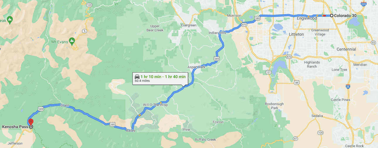
I am about to ask a simple question.  It is not a trick question, so no reason to over-think it.  The map below (like most maps) is oriented with north at the top.  You might not be able to make out much detail, but that's ok, because all I want you to do is take a look at the highway shown in blue.  And the question is simply this: does this highway run north-south?  Or does it run east-west?
Picture

Read More
5 Comments

Amarillo's dual one-way couplets

6/17/2021

0 Comments

 
US 87 and US 287 converge in Dumas, Texas, and share about 49 miles of pavement down to Amarillo, where the two routes separate again.  ​
DSCN7588

Read More
0 Comments

US highway history of San Angelo, Texas

4/10/2021

0 Comments

 
(Most recently updated 4/5/2022) 
Picture
Shield images courtesy of Michael Summa
One of San Angelo's marketing slogans is "The Oasis of West Texas".  This is not hyperbole; most approaches to the city are somewhat stark, so in contrast upon arrival in Angelo, one may well be pleasantly surprised at all of the rivers, reservoirs, trees and other vegetation:
San Angelo, edited
One of the city's other monikers is "The Pearl of the Conchos", which has a double meaning, referring to the freshwater Concho pearls that were historically harvested from area waterways.  The three branches of the Concho River all converge in San Angelo; that was illustrated on this other slogan from days gone by:
Picture
On display at ASU's Mayer Museum, Jun. 2021
When the US highway system was inaugurated in late 1926, the only US route to initially serve San Angelo was US 385 (that is, the original US 385, not the current US 385).  The new designation was added to Texas State Highway 9:

Read More
0 Comments
<<Previous
Forward>>

    RSS Feed

    Author

    This guy.

    Categories

    All
    Arizona
    Boston
    California
    Colorado
    Denver
    Florida
    Geo-center
    Geography
    Historic
    Idaho
    Illinois
    Indiana
    Kansas
    Kentucky
    Maryland
    Massachusetts
    Michigan
    Midpoint
    Mileage
    Minnesota
    Missouri
    Nebraska
    New Hampshire
    New Jersey
    New Mexico
    Newport
    New York
    North Carolina
    North Dakota
    Numbering
    Oddity
    Ohio
    Oklahoma
    Oregon
    Pennsylvania
    Proposed
    Renumbering
    Signage
    South Carolina
    South Dakota
    Tennessee
    Texas
    Updates
    US 101
    US 127
    US 13
    US 136
    US 150
    US 154
    US 16
    US 160
    US 163
    US 164
    US 169
    US 177
    US 180
    US 183
    US 190
    US 191
    US 20
    US 210
    US 212
    US 218
    US 220
    US 23
    US 24
    US 25
    US 259
    US 26
    US 266
    US 27
    US 270
    US 271
    US 277
    US 281
    US 283
    US 285
    US 287
    US 3
    US 31
    US 311
    US 321
    US 34
    US 36
    US 360
    US 371
    US 377
    US 383
    US 385
    US 40
    US 400
    US 411
    US 450
    US 46
    US 48
    US 491
    US 50
    US 530
    US 55
    US 59
    US 6
    US 60
    US 61
    US 62
    US 63
    US 65
    US 66
    US 666
    US 67
    US 730
    US 74
    US 77
    US 80
    US 81
    US 83
    US 84
    US 85
    US 87
    US 89
    US 93
    US 94
    US 96
    US 99
    Utah
    Virginia
    Washington
    Watersheds
    West Virginia
    Wyoming

    Archives

    May 2023
    March 2023
    February 2023
    January 2023
    August 2022
    March 2022
    February 2022
    January 2022
    August 2021
    July 2021
    June 2021
    April 2021
    February 2021
    January 2021
    August 2020
    July 2020
    May 2020
    April 2020
    March 2020
    February 2020
    January 2020
    December 2019
    October 2019
    September 2019
    August 2019
    May 2019
    January 2019
    November 2018
    June 2018
    April 2018
    March 2018
    November 2017
    September 2017
    August 2017
    June 2017
    March 2017
    February 2017
    January 2017
    December 2016

Copyright © 1998-2023
Picture