|
(Last updated 2/28/2023)
Of the "main" US highways (i.e. the one- and two-digit routes), the longest nine were all east-west routes (6, 20, 50, 30, 40, 60, 70, 80, 12). And if we take the longest 16 highways, only one of them is a north-south route (US 1, shown in red here): 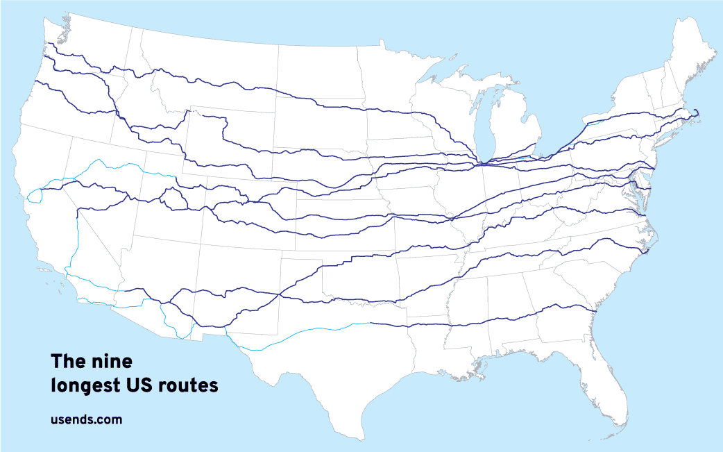
That stands to reason, because the United States is roughly twice as wide from east to west as it is from north to south. So it makes sense that there would be more long east-west routes.
0 Comments
From humble beginnings to great lengths
(last updated 11/27/2023)
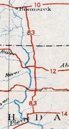
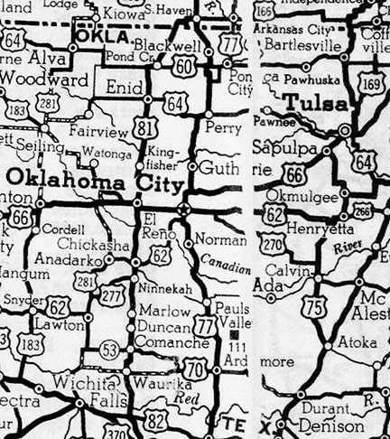
In 1925, when the US highway system was envisioned, there were plenty of proposed east-west routes crossing the Great Plains states, but there was a conspicuous lack of north-south routes between US 81 and US 85. This gap was about 300 miles wide in North Dakota, and it only increased to the south, until the gap was more like 500 miles wide in Texas. Obviously this was not an ideal situation for those six states, but a big obstacle prevented an easy remedy: there were very few decent-quality, long-distance, north-south roads through the Plains. One exception was the road between the capital cities of the two Dakotas. Those states petitioned AASHO for the US 83 designation, and by the time the US route system was officially inaugurated in 1926, their wish had been granted. For the next couple years, US 83 was a very short route -- only about 170 miles long -- running between Bismarck ND and Pierre SD:
However, by the early 1930s the US 83 designation had been extended not only north to the Canada border, but all the way down to the Mexico border too. This increased US 83's distance to nearly 1900 miles, and made it one of the longest north-south US routes. Additionally, as a result of US 83's new role as a trunk route, three newer US routes were numbered as branches of US 83. Two of these soon became quite lengthy themselves, and they still exist (US 183 and US 283). Just as these highways intertwine with each other, their history is also interrelated. This article examines the evolution of US 83, as well as the x83 routes that are part of its "family".
We will begin with the following map, which illustrates the current routings of US highways 136 and 150 between Indianapolis and Bloomington. From its eastern terminus in Indianapolis, US 136 (the blue line) heads west to Danville. US 150 (the red line) approaches Danville from the south. The two routes "bump" there before separating again, and then they have another intersection just south of the town of LeRoy IL:
US 50 is one of the longest highways in the U.S. How long is it? Well, there's actually some debate on that (this page has more details about why that is).
Both the Maryland and California state departments of transportation have placed reciprocal mileage signs at the terminus points, each claiming the total distance is 3073 miles. This photo was taken in Ocean City MD, looking along the east beginning of US 50...
(last updated 3/7/2022)
Many Route 66 tourists simply enjoy the romance and the lore of the fabled road. The facts aren't all that important, and if one of the legends turns out to be a tall-tale, they'd rather not know about it. And that's fine -- if you're one of those people, I say you gotta do you -- get out there and enjoy the Mother Road.
...then you might want to stop reading here, because this page contains research that discredits some of the "conventional wisdom" about US 66 that is found elsewhere. On the other hand, if you're interested in facts and details, then please carry on.
Why is it difficult to obtain accurate end-to-end mileage for many US highways?
(Last updated 10/25/2021) This comes as a surprise to some, but US highways are actually not federal highways... at least not in the sense that they are owned and maintained by the federal government. Rather, the US routes are actually just state highways... although they are "special" in the sense that at some point they were granted permission by AASHO (later AASHTO) to be signposted with a US route shield.

(last updated 8/21/2020)
"One great red line"
For about a quarter-century, US Route 6 was the longest highway in the country (and it may still be, depending how one measures). In Jack Kerouac's novel On the Road, the main character described it as "one great red line across America". During those years it ran between Provincetown MA and Long Beach CA, and I believe there has never been a longer highway in the United States. Exactly how long was it? Well, believe it or not, the answer to that question is debatable (see this page for more details about why it is difficult to calculate).
US 264, US 501, US 27, US 104, US 441, Apalachicola, Intra-state routes, Wrong-way overlaps, US 164[i], US 121[i], US 221, Joplin, US 202, US 641, US 136, US 34, US 48 [ii], US 36, US 21, US 219, US 220, Keokuk, Colors, US 171, New Orleans, Jacksonville, US 68, US 150, Philadelphia, US 64, US 11, Erie, Waverly, US 14, US 77, US 83, US 212, US 216, US 385. US 73, US 169
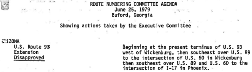
In 1979 Arizona asked AASHTO to extend the US 93 designation to Phoenix; following is the route description from the actual meeting minutes:
|
AuthorCategories
All
Archives
July 2024
|


 RSS Feed
Copyright © 1998-2024
