|
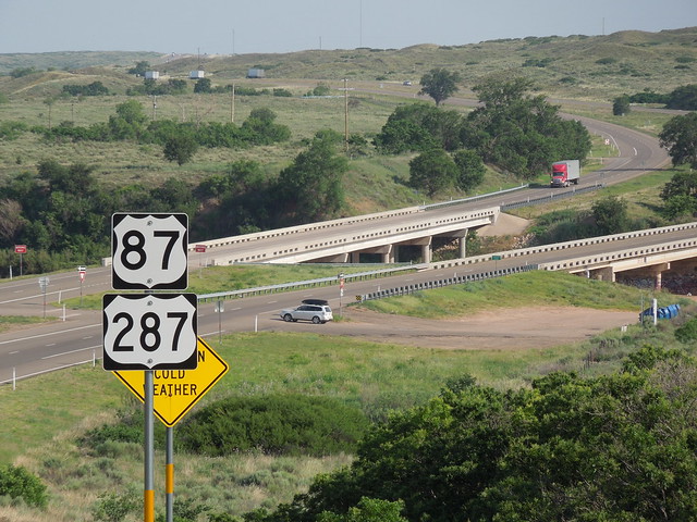
US 87 and US 287 converge in Dumas, Texas, and share about 49 miles of pavement down to Amarillo, where the two routes separate again.
0 Comments
(Most recently updated 4/5/2022)
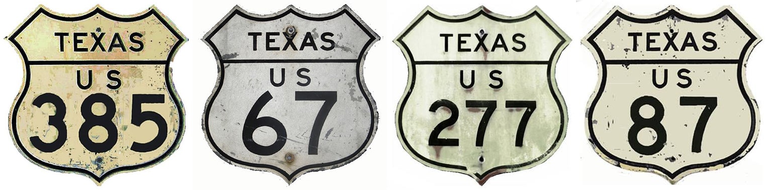
Shield images courtesy of Michael Summa
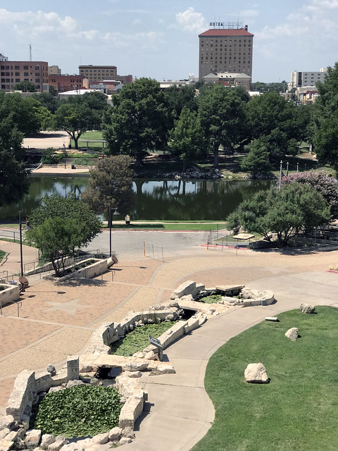
One of San Angelo's marketing slogans is "The Oasis of West Texas". This is not hyperbole; most approaches to the city are somewhat stark, so in contrast upon arrival in Angelo, one may well be pleasantly surprised at all of the rivers, reservoirs, trees and other vegetation:
One of the city's other monikers is "The Pearl of the Conchos", which has a double meaning, referring to the freshwater Concho pearls that were historically harvested from area waterways. The three branches of the Concho River all converge in San Angelo; that was illustrated on this other slogan from days gone by:
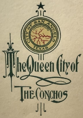
On display at ASU's Mayer Museum, Jun. 2021
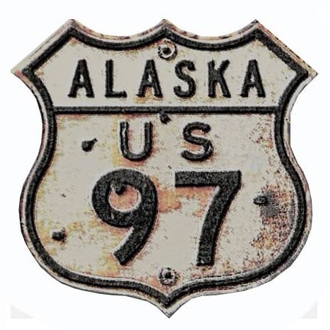
When the US highway system was inaugurated in late 1926, the only US route to initially serve San Angelo was US 385 (that is, the original US 385, not the current US 385). The new designation was added to Texas State Highway 9:
US 322, Tampa, US 67, US 522, US 31, US 51, US 176, US 44, US 113, Milwaukee, Original US 46 proposal, US 34, US 15, US 1, Minnesota rogue routes, US 301, Miami, Hardeeville, Walterboro, Fox Valley, Richmond, St. John IN, US 36, US 18, US 83, US 183, US 275, US 385, Rapid City, US 92, US 129, US 175, US 276, US 310, US 411[i], US 121[i], US 117[i], Wilson, Wilmington NC
When the US route system was conceived in the mid-1920s, one of the guidelines was that the longer, more important routes would be assigned 1- and 2-digit numbers. Given that, US 46 really seems like an outlier. At only 75 miles in length, it is the shortest of all 1- and 2-digit US routes. Not only that, but US 46 is entirely in one state (New Jersey). Why would AASHO consider a short, single-state highway to be worthy of a 2-digit US route designation? Historic documents in their route numbering archive reveal at least some of the answers. As it turns out, when US 46 was first proposed in the mid-1930s, it was envisioned as a route running between New York City and Cleveland, along the corridor shown on this map:
Some 1934 maps showed new US routes in Minnesota and/or extensions of US routes. This was due to a series of errors and misunderstandings involving AASHO, MNDoT, and commercial map publishers. By 1935 all of these misprints had been corrected. I will explain in more detail below, but first I will jump ahead to the final analysis:
(last updated 10/3/2023)
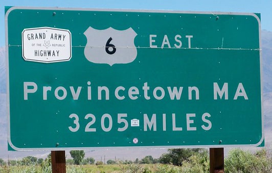
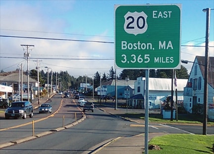
If you are familiar with the mileage signs posted at the terminus points of US 6 and US 20, you might point to those and say, "The answer is plain to see: US 20 is 160 miles longer than US 6."
If both of those signs were accurate, then obviously US 20 would be longer. But the fact is, only the US 6 sign is accurate, whereas the US 20 sign significantly overstates the true mileage. In reality, the mileages of the two routes are very close, and in fact there is every reason to believe US 6 is actually a slightly longer route.
One of the many interesting things about this segment of US 34 is that it essentially follows the valley of the Colorado River between its headwaters in Rocky Mountain National Park and its confluence with the Fraser River in Granby. Consequently US 34 also provides access to all of the major water collection components of the Colorado-Big Thompson Project. Those include Grand Lake (Colorado's largest and deepest natural lake) and three artificial impoundments (Shadow Mountain Lake, Lake Granby, and Willow Creek Reservoir). Since there are many examples of highways which were originally built parallel to rivers, but which later had to be realigned because of water storage projects that were built in those valleys, I set out to explore whether US 34 had any historic alignments that existed prior to the reservoirs in the Middle Park area.
US 411[i], US 121[i], US 117[i], Wilson, Wilmington NC, Pee Dee, Florence, US 21, US 170, US 421, US 3, Chattanooga, US 72, US 222, US 541, US 411, US 138, US 119, US 522, Brownsville, US 83 history, US 99, US 51, US 63, US 20, Wilmington DE, Cincinnati, US 22, US 124, US 136, US 150, US 152, US 8, US 264, US 501, US 27, US 104, US 441, Apalachicola, Intra-state routes, Wrong-way overlaps
|
AuthorCategories
All
Archives
July 2024
|


 RSS Feed
Copyright © 1998-2024
